---
title: Map of Christian Pilgrimage in the Middle Ages, c. 1000
author: Simeon Netchev
source: https://www.worldhistory.org/image/16082/map-of-christian-pilgrimage-in-the-middle-ages-c-1/
format: machine-readable-alternate
license: Creative Commons Attribution-NonCommercial-NoDerivs (https://creativecommons.org/licenses/by-nc/4.0)
updated: 2025-06-29
---
# Map of Christian Pilgrimage in the Middle Ages, c. 1000
_Authored by [Simeon Netchev](https://www.worldhistory.org/user/simeonnetchev/)_
## Image File
[](https://www.worldhistory.org/uploads/images/16082.png)
## Image Caption
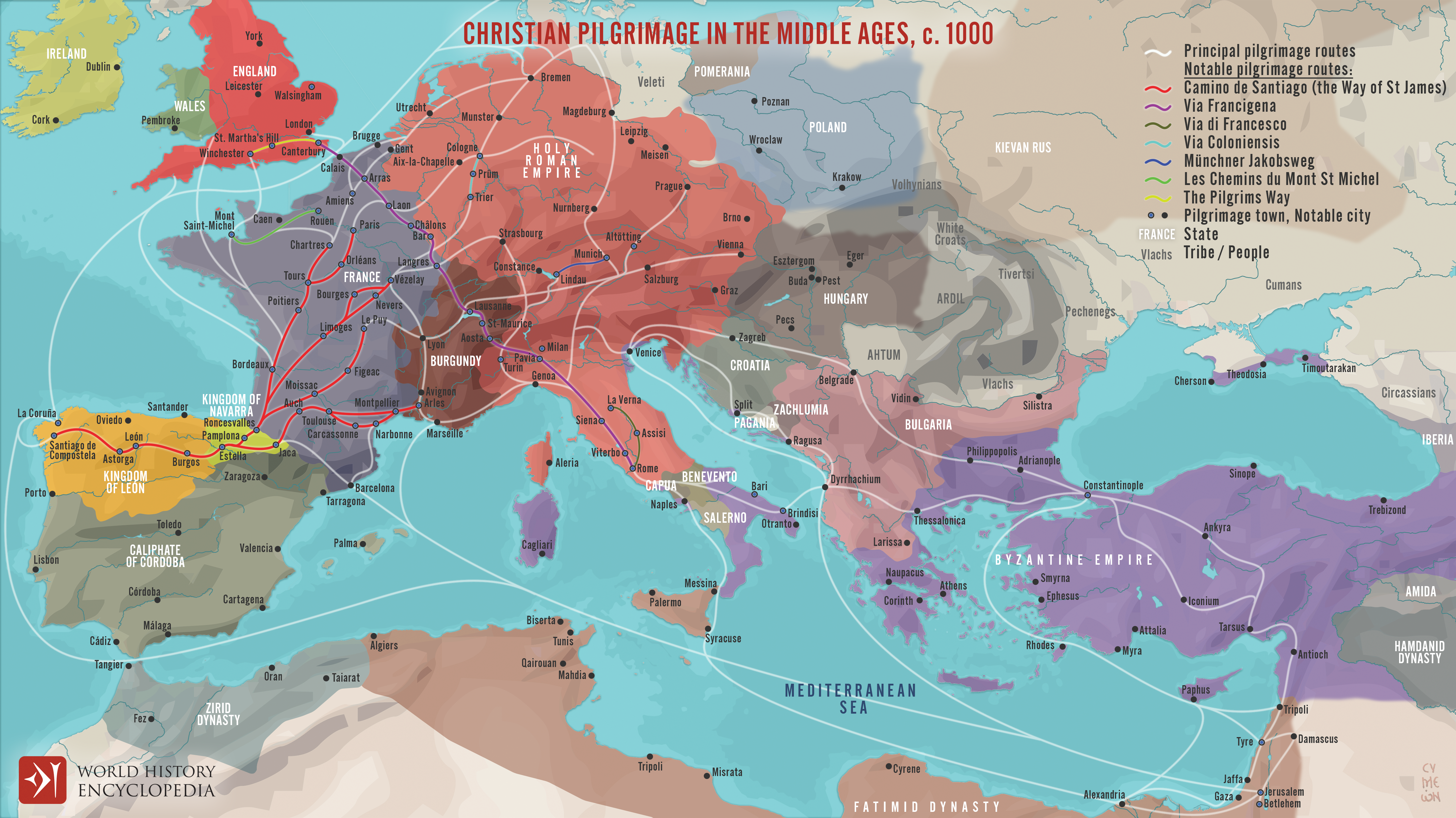
This map illustrates the changing patterns of Christian pilgrimage during the Middle Ages: for most Europeans the long, perilous, and costly journey to the Holy Land was too far, dangerous, and forbiddingly expensive, so devotion redirected toward nearer shrines. Routes now funneled the faithful to regional sanctuaries where relics of saints and martyrs promised spiritual merit closer to home.
Major alternatives emerged: [Rome](https://www.worldhistory.org/Rome/), seat of the Papacy, Santiago de Compostela in Christian Spain, Canterbury in Norman–Plantagenet [England](https://www.worldhistory.org/disambiguation/england/) and countless local sites from Cologne to Kraków. Monasteries curated relics, towns prospered from pilgrims’ spending, and rulers such as [Henry II of England](https://www.worldhistory.org/Henry_II_of_England/) (reigned 1154–1189) or Louis IX of France (reigned 1226–1270) endorsed new shrines to bolster piety and prestige. Thus medieval pilgrimage became a dense network of regional journeys, weaving spiritual practice into [Europe](https://www.worldhistory.org/europe/)’s economic and cultural landscape.
#### Editorial Review
This human-authored image has been reviewed by our editorial team before publication to ensure accuracy, reliability and adherence to academic standards in accordance with our [editorial policy](https://www.worldhistory.org/static/editorial-policy/).
## About the Author
Simeon is a freelance visual designer and history educator, passionate about the human stories that shape the past.
- [Linkedin Profile](https://www.linkedin.com/in/simeon-netchev/)
## External Links
- [Medieval Trade Routes Map](https://easyzoom.com/image/218139)
## Cite This Work
### APA
Netchev, S. (2022, July 04). Map of Christian Pilgrimage in the Middle Ages, c. 1000. *World History Encyclopedia*.
### Chicago
Netchev, Simeon. "Map of Christian Pilgrimage in the Middle Ages, c. 1000." *World History Encyclopedia*, July 04, 2022. .
### MLA
Netchev, Simeon. "Map of Christian Pilgrimage in the Middle Ages, c. 1000." *World History Encyclopedia*, 04 Jul 2022, .
## License & Copyright
Submitted by [Simeon Netchev](https://www.worldhistory.org/user/simeonnetchev/ "User Page: Simeon Netchev"), published on 04 July 2022. The copyright holder has published this content under the following license: [Creative Commons Attribution-NonCommercial-NoDerivs](https://creativecommons.org/licenses/by-nc/4.0deed.en). This licence only allows others to download this content and share it with others as long as the author is credited, but they can't change the content in any way or use it commercially. When republishing on the web a hyperlink back to the original content source URL must be included. Please note that content linked from this page may have different licensing terms.