---
title: Map of the Mamluk Sultanate of Egypt c. 1330: Slave Soldiers Who Ruled an Empire
author: Simeon Netchev
source: https://www.worldhistory.org/image/16003/map-of-the-mamluk-sultanate-of-egypt-c-1330/
format: machine-readable-alternate
license: Creative Commons Attribution-NonCommercial-NoDerivs (https://creativecommons.org/licenses/by-nc/4.0)
updated: 2026-02-28
---
# Map of the Mamluk Sultanate of Egypt c. 1330: Slave Soldiers Who Ruled an Empire
_Authored by [Simeon Netchev](https://www.worldhistory.org/user/simeonnetchev/)_
## Image File
[](https://www.worldhistory.org/uploads/images/16003.png)
## Image Caption
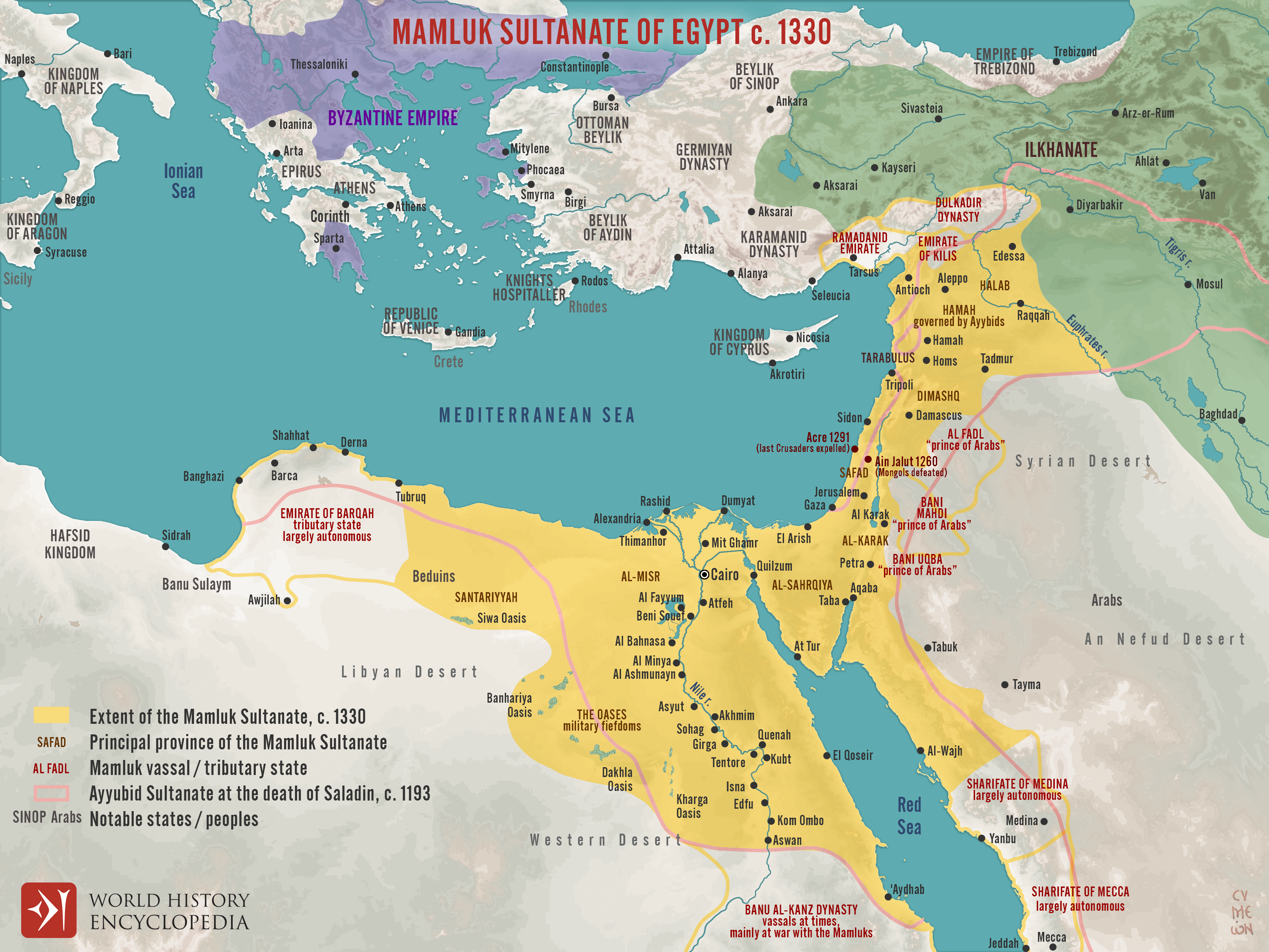
The Mamluk Sultanate of [Egypt](https://www.worldhistory.org/egypt/) (1250–1517) emerged from the military elite of the late Ayyubid state and transformed a [palace](https://www.worldhistory.org/disambiguation/palace/) coup into one of the most durable powers of the late medieval Islamic world. Following the [death](https://www.worldhistory.org/disambiguation/Death/) of al-Ṣāliḥ Ayyūb (reign 1240–1249), his mamlūk regiments in Egypt seized authority (1250), briefly elevating Shajar al-Durr before consolidating rule under Aybak (reign 1250–1257). Although the early decades were marked by factional rivalries between competing military households, the sultanate quickly established legitimacy through military success and custodianship of key Islamic territories. Its decisive victory over the [Mongols](https://www.worldhistory.org/Mongol_Empire/) at the [Battle](https://www.worldhistory.org/disambiguation/battle/) of ʿAyn Jālūt (1260), under Sultan Qutuz (reign 1259–1260) and Baybars (reign 1260–1277), halted further [Mongol](https://www.worldhistory.org/Mongol_Empire/) expansion into [Syria](https://www.worldhistory.org/syria/) and Egypt, reinforcing Cairo’s strategic centrality in the eastern [Mediterranean](https://www.worldhistory.org/disambiguation/mediterranean/).
Over the following decades, the Mamluks dismantled the remaining Crusader strongholds, culminating in the fall of Acre (1291), and consolidated control over Egypt, Syria, the [Levant](https://www.worldhistory.org/levant/), and the Hijaz. Under rulers such as al-Nasir [Muhammad](https://www.worldhistory.org/disambiguation/Muhammad/) (reign 1293–1294; 1299–1309; 1310–1341), the sultanate developed a centralized administrative structure supported by iqṭāʿ land grants, a powerful cavalry elite, and revenues derived from Red Sea and Mediterranean [trade](https://www.worldhistory.org/disambiguation/trade/) networks, particularly the spice trade. Control of Mecca and Medina enhanced its religious prestige, while architectural patronage in Cairo symbolized political authority. Despite cycles of court intrigue and elite factionalism, the regime endured for over 260 years until defeat by the expanding [Ottoman Empire](https://www.worldhistory.org/Ottoman_Empire/) under Selim I (reign 1512–1520) at Marj Dābiq (1516) and al-Ridāniyya (1517), integrated Egypt and Syria into a rapidly consolidating imperial system, marking a major shift in the balance of power within the eastern Mediterranean and the broader Islamic world.
#### Editorial Review
This human-authored image has been reviewed by our editorial team before publication to ensure accuracy, reliability and adherence to academic standards in accordance with our [editorial policy](https://www.worldhistory.org/static/editorial-policy/).
## About the Author
Simeon is a freelance visual designer and history educator, passionate about the human stories that shape the past.
- [Linkedin Profile](https://www.linkedin.com/in/simeon-netchev/)
## Cite This Work
### APA
Netchev, S. (2026, February 28). Map of the Mamluk Sultanate of Egypt c. 1330: Slave Soldiers Who Ruled an Empire. *World History Encyclopedia*.
### Chicago
Netchev, Simeon. "Map of the Mamluk Sultanate of Egypt c. 1330: Slave Soldiers Who Ruled an Empire." *World History Encyclopedia*, February 28, 2026. .
### MLA
Netchev, Simeon. "Map of the Mamluk Sultanate of Egypt c. 1330: Slave Soldiers Who Ruled an Empire." *World History Encyclopedia*, 28 Feb 2026, .
## License & Copyright
Submitted by [Simeon Netchev](https://www.worldhistory.org/user/simeonnetchev/ "User Page: Simeon Netchev"), published on 28 February 2026. The copyright holder has published this content under the following license: [Creative Commons Attribution-NonCommercial-NoDerivs](https://creativecommons.org/licenses/by-nc/4.0deed.en). This licence only allows others to download this content and share it with others as long as the author is credited, but they can't change the content in any way or use it commercially. When republishing on the web a hyperlink back to the original content source URL must be included. Please note that content linked from this page may have different licensing terms.