---
title: Map of the Trade Networks in the Middle Ages, c. 1200
author: Simeon Netchev
source: https://www.worldhistory.org/image/15923/map-of-the-trade-networks-in-the-middle-ages-c-120/
format: machine-readable-alternate
license: Creative Commons Attribution-NonCommercial-NoDerivs (https://creativecommons.org/licenses/by-nc/4.0)
updated: 2026-01-12
---
# Map of the Trade Networks in the Middle Ages, c. 1200
_Authored by [Simeon Netchev](https://www.worldhistory.org/user/simeonnetchev/)_
## Image File
[](https://www.worldhistory.org/uploads/images/15923.png)
## Image Caption
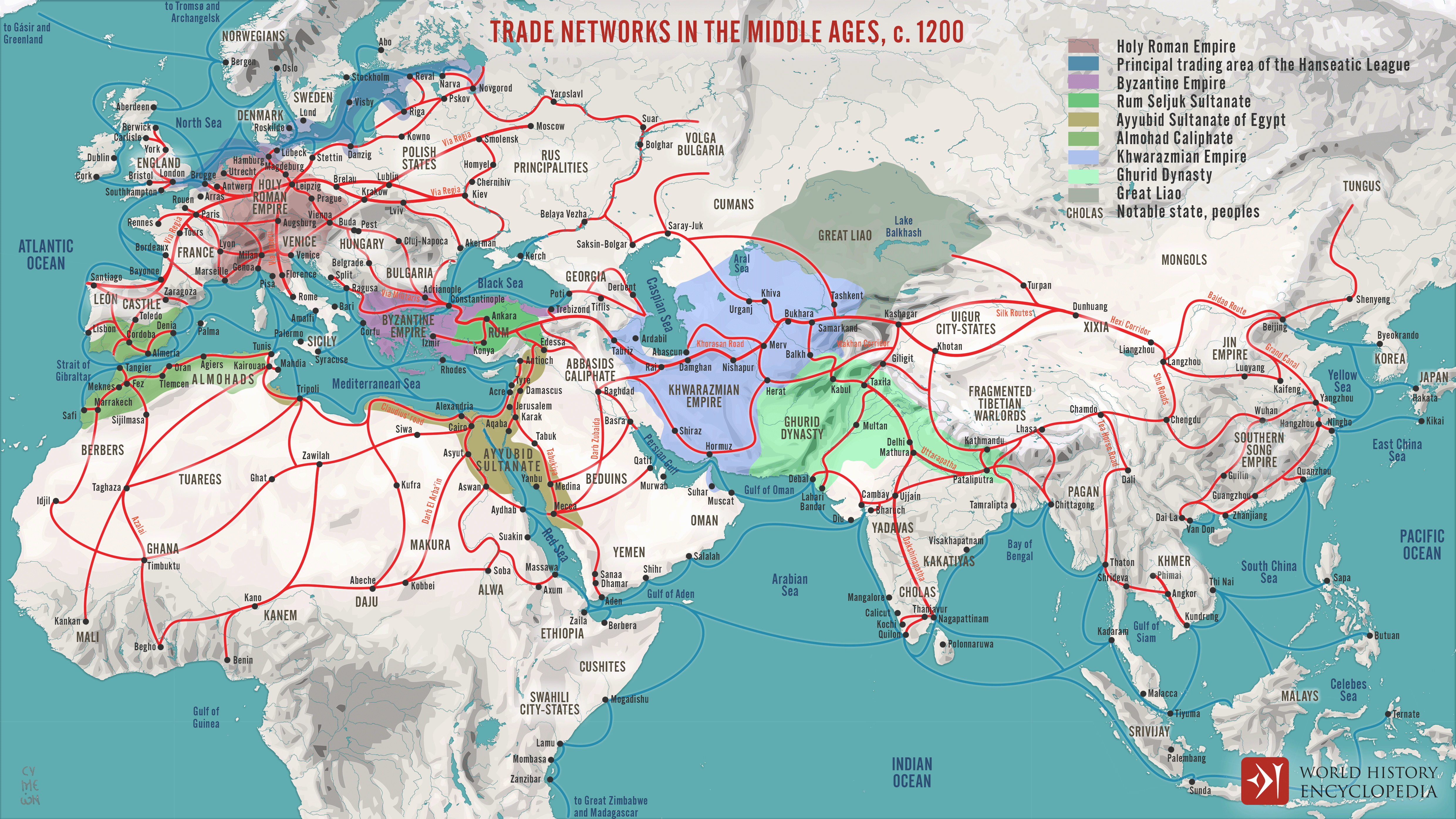
By the early 13th century (c. 1200 CE), long-distance [trade](https://www.worldhistory.org/disambiguation/trade/) networks across Eurasia and the [Mediterranean](https://www.worldhistory.org/disambiguation/mediterranean/) had regained a level of interconnectivity not seen since late antiquity. After the political fragmentation that followed the [fall of the Western Roman Empire](https://www.worldhistory.org/article/835/fall-of-the-western-roman-empire/) (c. 476 CE), economic recovery, population growth, and institutional stabilization gradually revived exchange between [Europe](https://www.worldhistory.org/europe/), the Islamic world, [Byzantium](https://www.worldhistory.org/Byzantium/), and Asia. Trade routes, both maritime and overland, once again linked distant regions, enabling sustained movement of goods, capital, and information across cultural and political boundaries.
Despite persistent conflict, including the [Crusades](https://www.worldhistory.org/Crusades/) (1096–1291), commerce between Christian and Muslim realms flourished. The Mediterranean functioned as a major artery of exchange, where Italian maritime republics expanded their commercial reach, while Islamic states such as the Ayyubid Sultanate under [Saladin](https://www.worldhistory.org/Saladin/) (reign 1171–1193) controlled key urban and transit hubs. The Eastern [Roman](https://www.worldhistory.org/disambiguation/Roman/) ([Byzantine](https://www.worldhistory.org/disambiguation/Byzantine/)) [Empire](https://www.worldhistory.org/empire/), though territorially reduced, continued to serve as a vital intermediary between East and West. At the same time, overland routes through Central Asia, soon to be stabilized under [Mongol](https://www.worldhistory.org/Mongol_Empire/) rule (from the early 13th century), fed into this system. Europe increasingly exported woolen textiles and [metal](https://www.worldhistory.org/disambiguation/metal/) goods, importing [silk](https://www.worldhistory.org/Silk/), spices, and luxury products from the eastern Mediterranean, [India](https://www.worldhistory.org/india/), and [China](https://www.worldhistory.org/china/), marking a decisive re-integration of Eurasian commerce on the eve of the Mongol era.
I would like to thank @Martin\_Maansson for his extensive research, inspiration, and [amazing map](https://easyzoom.com/image/218139) of the medieval trade routes.
#### Editorial Review
This human-authored image has been reviewed by our editorial team before publication to ensure accuracy, reliability and adherence to academic standards in accordance with our [editorial policy](https://www.worldhistory.org/static/editorial-policy/).
## About the Author
Simeon is a freelance visual designer and history educator, passionate about the human stories that shape the past.
- [Linkedin Profile](https://www.linkedin.com/in/simeon-netchev/)
## External Links
- [Medieval Trade Routes Map](https://easyzoom.com/image/218139)
## Cite This Work
### APA
Netchev, S. (2022, May 24). Map of the Trade Networks in the Middle Ages, c. 1200. *World History Encyclopedia*.
### Chicago
Netchev, Simeon. "Map of the Trade Networks in the Middle Ages, c. 1200." *World History Encyclopedia*, May 24, 2022. .
### MLA
Netchev, Simeon. "Map of the Trade Networks in the Middle Ages, c. 1200." *World History Encyclopedia*, 24 May 2022, .
## License & Copyright
Submitted by [Simeon Netchev](https://www.worldhistory.org/user/simeonnetchev/ "User Page: Simeon Netchev"), published on 24 May 2022. The copyright holder has published this content under the following license: [Creative Commons Attribution-NonCommercial-NoDerivs](https://creativecommons.org/licenses/by-nc/4.0deed.en). This licence only allows others to download this content and share it with others as long as the author is credited, but they can't change the content in any way or use it commercially. When republishing on the web a hyperlink back to the original content source URL must be included. Please note that content linked from this page may have different licensing terms.