---
title: Map of the Taifa Kingdoms of al-Andalus (c. 1031–1086): Iberian Peninsula on the Eve of the Almoravid Intervention
author: Simeon Netchev
source: https://www.worldhistory.org/image/15872/map-of-the-taifa-kingdoms-of-al-andalus-c-1031-108/
format: machine-readable-alternate
license: Creative Commons Attribution-NonCommercial-NoDerivs (https://creativecommons.org/licenses/by-nc/4.0)
updated: 2025-12-27
---
# Map of the Taifa Kingdoms of al-Andalus (c. 1031–1086): Iberian Peninsula on the Eve of the Almoravid Intervention
_Authored by [Simeon Netchev](https://www.worldhistory.org/user/simeonnetchev/)_
## Image File
[](https://www.worldhistory.org/uploads/images/15872.png)
## Image Caption
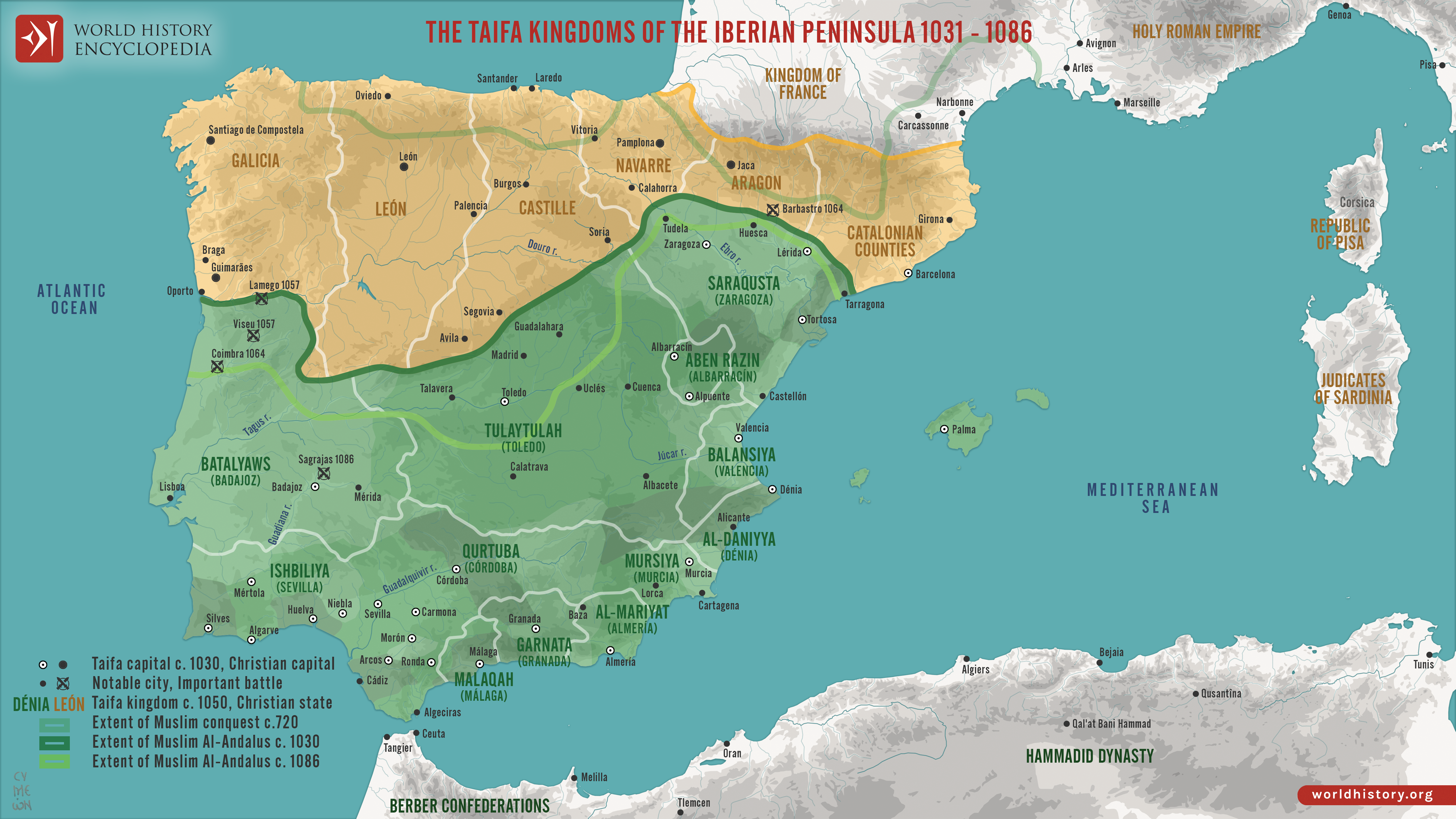
The political fragmentation of al-Andalus began with the collapse of the [Umayyad Caliphate](https://www.worldhistory.org/Umayyad_Dynasty/) of Córdoba (756–1031), culminating in its formal dissolution in 1031. In the power vacuum that followed, the Iberian Peninsula fractured into dozens of independent Muslim-ruled states known as taifas (from the Arabic ṭāʾifa, meaning “faction” or “party”). These [taifa](https://www.worldhistory.org/Taifa/) kingdoms, ruled by local dynasties of Arab, [Berber](https://www.worldhistory.org/Berbers/), and Ṣaqāliba (Slavic-origin) elites, competed through [warfare](https://www.worldhistory.org/warfare/), diplomacy, and shifting alliances while attempting to preserve legitimacy and autonomy in an increasingly unstable political landscape.
At their height, there may have been up to fifty taifas, though power gradually concentrated in major centers such as Seville, Toledo, Zaragoza, Badajoz, Valencia, and Granada. Despite periods of cultural and economic prosperity, political division left the taifas vulnerable to external pressure, most notably from the expanding Christian kingdoms of the north. The capture of Toledo in 1085 by Alfonso VI of León and Castile (reign 1065–1109) marked a decisive turning point. Facing existential threat, several taifa rulers appealed to the Almoravids, a reformist Berber dynasty from North [Africa](https://www.worldhistory.org/disambiguation/africa/), whose intervention led to the military defeat and eventual absorption of the taifas by c. 1090. This transition ended the first taifa period and ushered in a new phase of political centralization under external Islamic rule.
#### Editorial Review
This human-authored image has been reviewed by our editorial team before publication to ensure accuracy, reliability and adherence to academic standards in accordance with our [editorial policy](https://www.worldhistory.org/static/editorial-policy/).
## About the Author
Simeon is a freelance visual designer and history educator, passionate about the human stories that shape the past.
- [Linkedin Profile](https://www.linkedin.com/in/simeon-netchev/)
## Cite This Work
### APA
Netchev, S. (2025, December 27). Map of the Taifa Kingdoms of al-Andalus (c. 1031–1086): Iberian Peninsula on the Eve of the Almoravid Intervention. *World History Encyclopedia*.
### Chicago
Netchev, Simeon. "Map of the Taifa Kingdoms of al-Andalus (c. 1031–1086): Iberian Peninsula on the Eve of the Almoravid Intervention." *World History Encyclopedia*, December 27, 2025. .
### MLA
Netchev, Simeon. "Map of the Taifa Kingdoms of al-Andalus (c. 1031–1086): Iberian Peninsula on the Eve of the Almoravid Intervention." *World History Encyclopedia*, 27 Dec 2025, .
## License & Copyright
Submitted by [Simeon Netchev](https://www.worldhistory.org/user/simeonnetchev/ "User Page: Simeon Netchev"), published on 27 December 2025. The copyright holder has published this content under the following license: [Creative Commons Attribution-NonCommercial-NoDerivs](https://creativecommons.org/licenses/by-nc/4.0deed.en). This licence only allows others to download this content and share it with others as long as the author is credited, but they can't change the content in any way or use it commercially. When republishing on the web a hyperlink back to the original content source URL must be included. Please note that content linked from this page may have different licensing terms.