---
title: Map of the Giza Complex of Ancient Egypt: Monumental Landscape of the Pyramid Age
author: Simeon Netchev
source: https://www.worldhistory.org/image/15684/map-of-the-giza-complex-of-ancient-egypt/
format: machine-readable-alternate
license: Creative Commons Attribution-NonCommercial-NoDerivs (https://creativecommons.org/licenses/by-nc/4.0)
updated: 2026-03-16
---
# Map of the Giza Complex of Ancient Egypt: Monumental Landscape of the Pyramid Age
_Authored by [Simeon Netchev](https://www.worldhistory.org/user/simeonnetchev/)_
## Image File
[](https://www.worldhistory.org/uploads/images/15684.png)
## Image Caption
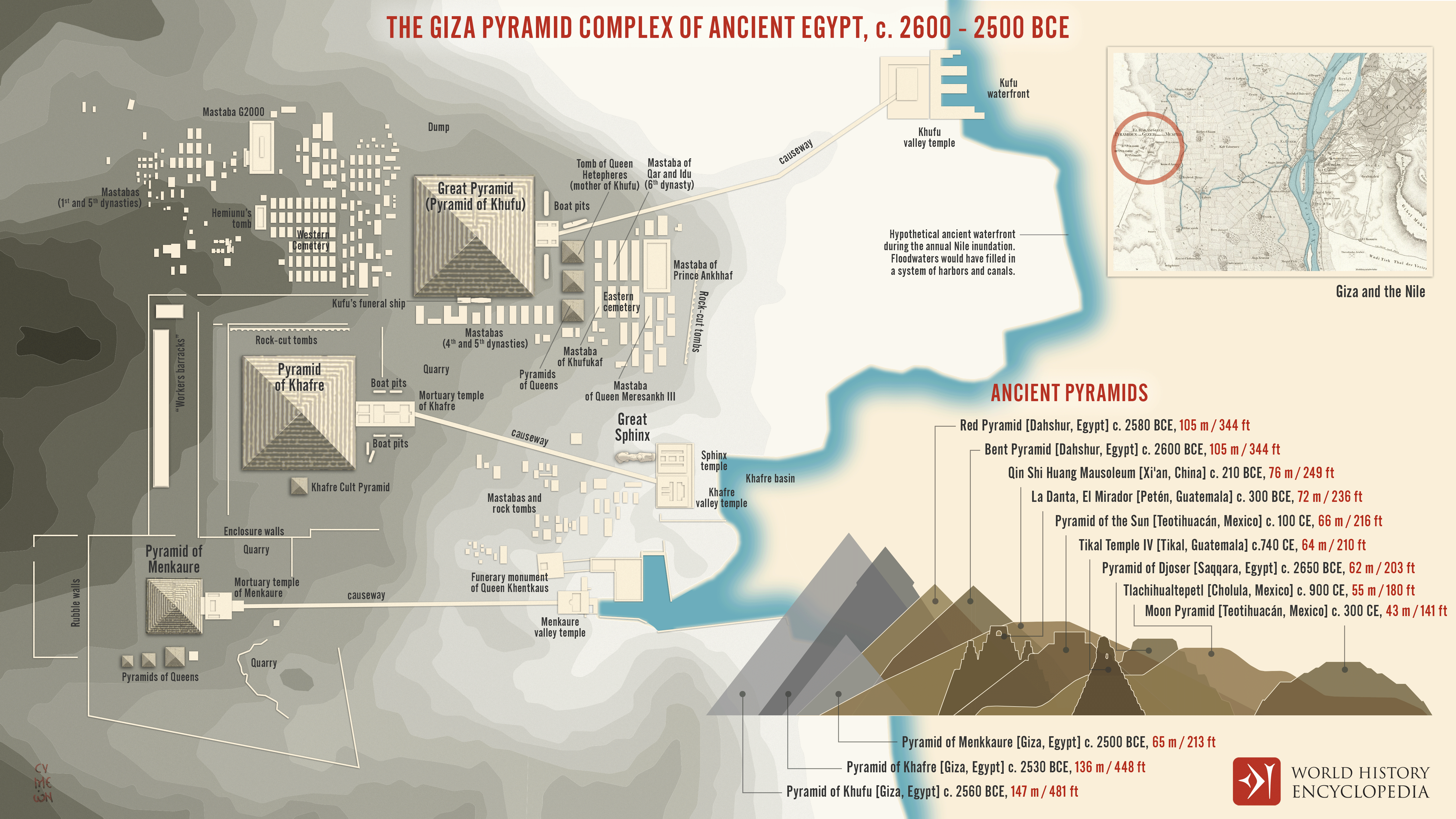
The [Giza](https://www.worldhistory.org/giza/) plateau formed one of the most important royal funerary landscapes of the [Old Kingdom of Egypt](https://www.worldhistory.org/Old_Kingdom_of_Egypt/), a period sometimes described as the “*Age of the [Pyramids](https://www.worldhistory.org/pyramid/)*.” Located near [Memphis](https://www.worldhistory.org/Memphis_(Ancient_Egypt)/), the political center of [early dynastic](https://www.worldhistory.org/disambiguation/Early_Dynastic/) [Egypt](https://www.worldhistory.org/egypt/), Giza became the principal [burial](https://www.worldhistory.org/burial/) site for rulers of the Fourth Dynasty of Egypt. During the reigns of Khufu (reign c. 2589–2566 BCE), Khafre (reign c. 2558–2532 BCE), and Menkaure (reign c. 2532–2503 BCE), the plateau was transformed into a carefully organized complex of pyramids, temples, causeways, cemeteries, and supporting settlements. These monuments were not isolated structures but components of a coordinated funerary landscape linking royal tombs to valley temples near the [Nile](https://www.worldhistory.org/nile/) floodplain and to ritual spaces used for mortuary cults.
The pyramids themselves symbolized royal authority and cosmic order within ancient [Egyptian](https://www.worldhistory.org/disambiguation/Egyptian/) religious thought, reflecting the king’s role as intermediary between the gods and society. Their construction required extensive state organization, skilled labor, and access to regional resources, supported by nearby workers’ settlements and harbor facilities connected to branches of the Nile. Surrounding cemeteries of mastabas housed members of the royal family, officials, and priests responsible for maintaining funerary rituals. Together, these architectural and environmental relationships illustrate how royal ideology, geography, and administrative capacity converged at Giza, creating one of the most enduring monumental landscapes of the ancient world during the mid–third millennium BCE.
#### Editorial Review
This human-authored image has been reviewed by our editorial team before publication to ensure accuracy, reliability and adherence to academic standards in accordance with our [editorial policy](https://www.worldhistory.org/static/editorial-policy/).
## About the Author
Simeon is a freelance visual designer and history educator, passionate about the human stories that shape the past.
- [Linkedin Profile](https://www.linkedin.com/in/simeon-netchev/)
## Cite This Work
### APA
Netchev, S. (2026, March 16). Map of the Giza Complex of Ancient Egypt: Monumental Landscape of the Pyramid Age. *World History Encyclopedia*.
### Chicago
Netchev, Simeon. "Map of the Giza Complex of Ancient Egypt: Monumental Landscape of the Pyramid Age." *World History Encyclopedia*, March 16, 2026. .
### MLA
Netchev, Simeon. "Map of the Giza Complex of Ancient Egypt: Monumental Landscape of the Pyramid Age." *World History Encyclopedia*, 16 Mar 2026, .
## License & Copyright
Submitted by [Simeon Netchev](https://www.worldhistory.org/user/simeonnetchev/ "User Page: Simeon Netchev"), published on 16 March 2026. The copyright holder has published this content under the following license: [Creative Commons Attribution-NonCommercial-NoDerivs](https://creativecommons.org/licenses/by-nc/4.0deed.en). This licence only allows others to download this content and share it with others as long as the author is credited, but they can't change the content in any way or use it commercially. When republishing on the web a hyperlink back to the original content source URL must be included. Please note that content linked from this page may have different licensing terms.