---
title: Map of the Roman Trade Network (1st - 3rd centuries CE)
author: Simeon Netchev
source: https://www.worldhistory.org/image/15641/map-of-the-roman-trade-network-1st---3rd-centuries/
format: machine-readable-alternate
license: Creative Commons Attribution-NonCommercial-NoDerivs (https://creativecommons.org/licenses/by-nc/4.0)
updated: 2025-05-26
---
# Map of the Roman Trade Network (1st - 3rd centuries CE)
_Authored by [Simeon Netchev](https://www.worldhistory.org/user/simeonnetchev/)_
## Image File
[](https://www.worldhistory.org/uploads/images/15641.png)
## Image Caption
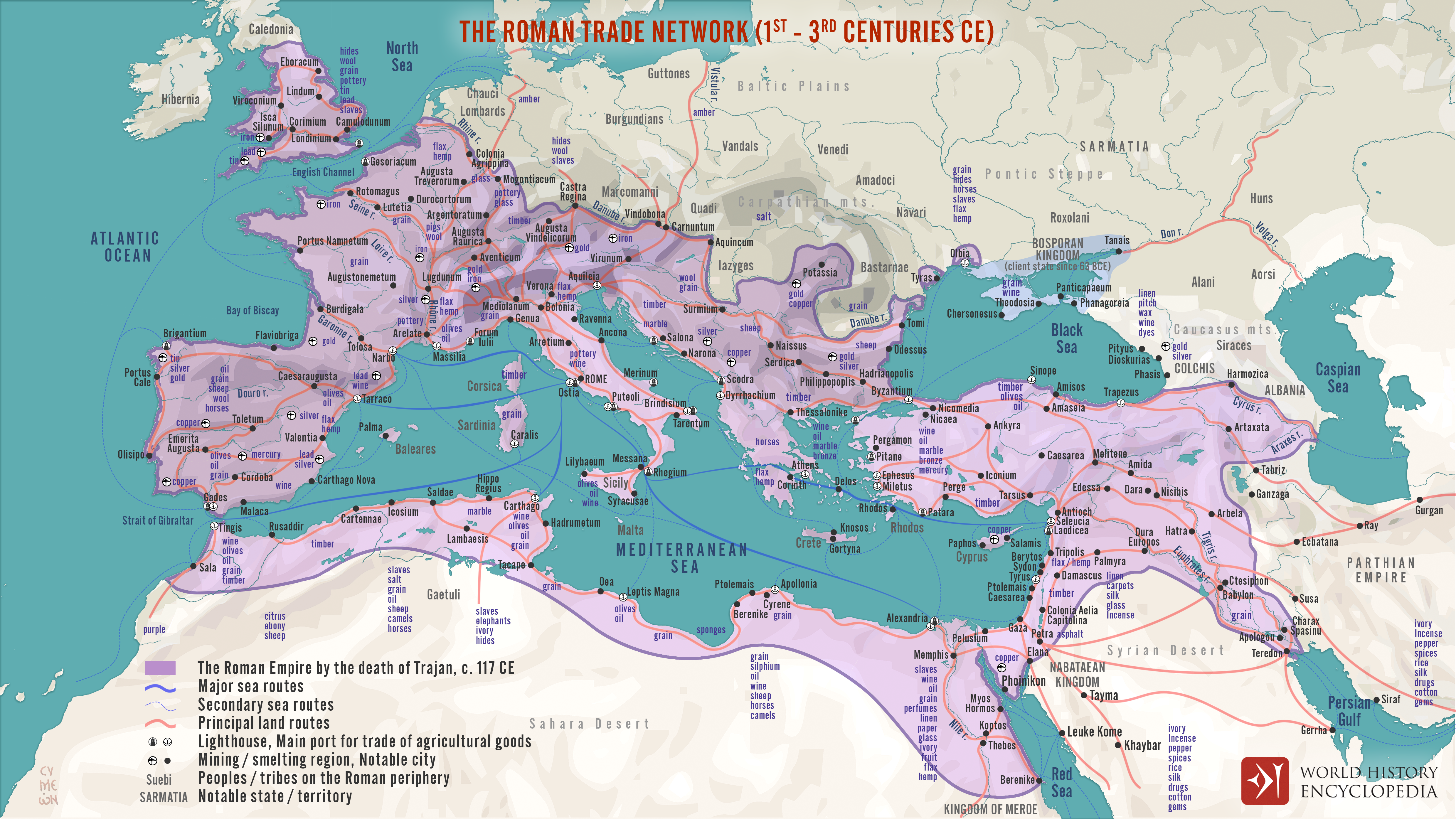
This map illustrates the main maritime and overland [trade](https://www.worldhistory.org/disambiguation/trade/) arteries that bound the [Roman Empire](https://www.worldhistory.org/Roman_Empire/) together between the first and third centuries CE. From grain fleets in the [Mediterranean](https://www.worldhistory.org/disambiguation/mediterranean/) to camel caravans across the desert and river barges on the Rhine and [Nile](https://www.worldhistory.org/nile/), commerce moved people, ideas, and luxury goods.
The routes are schematic: ancient pilots adjusted courses to shifting Mediterranean winds, so outbound and return tracks often differed, and exact sea lanes remain only partly known. Overland, merchants stitched provinces together via a web of paved roads, rivers, and canals whose complexity varied from [Gaul](https://www.worldhistory.org/gaul/) to [Syria](https://www.worldhistory.org/syria/). By visualizing these flexible corridors—rather than fixed “highways”—the map captures how [Roman](https://www.worldhistory.org/disambiguation/Roman/) connectivity relied on season, terrain, and local infrastructure as much as imperial reach.
#### Editorial Review
This human-authored image has been reviewed by our editorial team before publication to ensure accuracy, reliability and adherence to academic standards in accordance with our [editorial policy](https://www.worldhistory.org/static/editorial-policy/).
## About the Author
Simeon is a freelance visual designer and history educator, passionate about the human stories that shape the past.
- [Linkedin Profile](https://www.linkedin.com/in/simeon-netchev/)
## External Links
- [Trade Routes and Thermal Winds](https://www.chantrou.net/post/h-146-trade-routes-and-thermal-winds)
## Cite This Work
### APA
Netchev, S. (2022, April 07). Map of the Roman Trade Network (1st - 3rd centuries CE). *World History Encyclopedia*.
### Chicago
Netchev, Simeon. "Map of the Roman Trade Network (1st - 3rd centuries CE)." *World History Encyclopedia*, April 07, 2022. .
### MLA
Netchev, Simeon. "Map of the Roman Trade Network (1st - 3rd centuries CE)." *World History Encyclopedia*, 07 Apr 2022, .
## License & Copyright
Submitted by [Simeon Netchev](https://www.worldhistory.org/user/simeonnetchev/ "User Page: Simeon Netchev"), published on 07 April 2022. The copyright holder has published this content under the following license: [Creative Commons Attribution-NonCommercial-NoDerivs](https://creativecommons.org/licenses/by-nc/4.0deed.en). This licence only allows others to download this content and share it with others as long as the author is credited, but they can't change the content in any way or use it commercially. When republishing on the web a hyperlink back to the original content source URL must be included. Please note that content linked from this page may have different licensing terms.