---
title: Map of the Akkadian Empire at Its Height: Ruling the Four Quarters of the World
author: Simeon Netchev
source: https://www.worldhistory.org/image/15457/map-of-the-akkadian-empire-at-its-height/
format: machine-readable-alternate
license: Creative Commons Attribution-NonCommercial-NoDerivs (https://creativecommons.org/licenses/by-nc/4.0)
updated: 2026-04-02
---
# Map of the Akkadian Empire at Its Height: Ruling the Four Quarters of the World
_Authored by [Simeon Netchev](https://www.worldhistory.org/user/simeonnetchev/)_
## Image File
[](https://www.worldhistory.org/uploads/images/15457.png)
## Image Caption
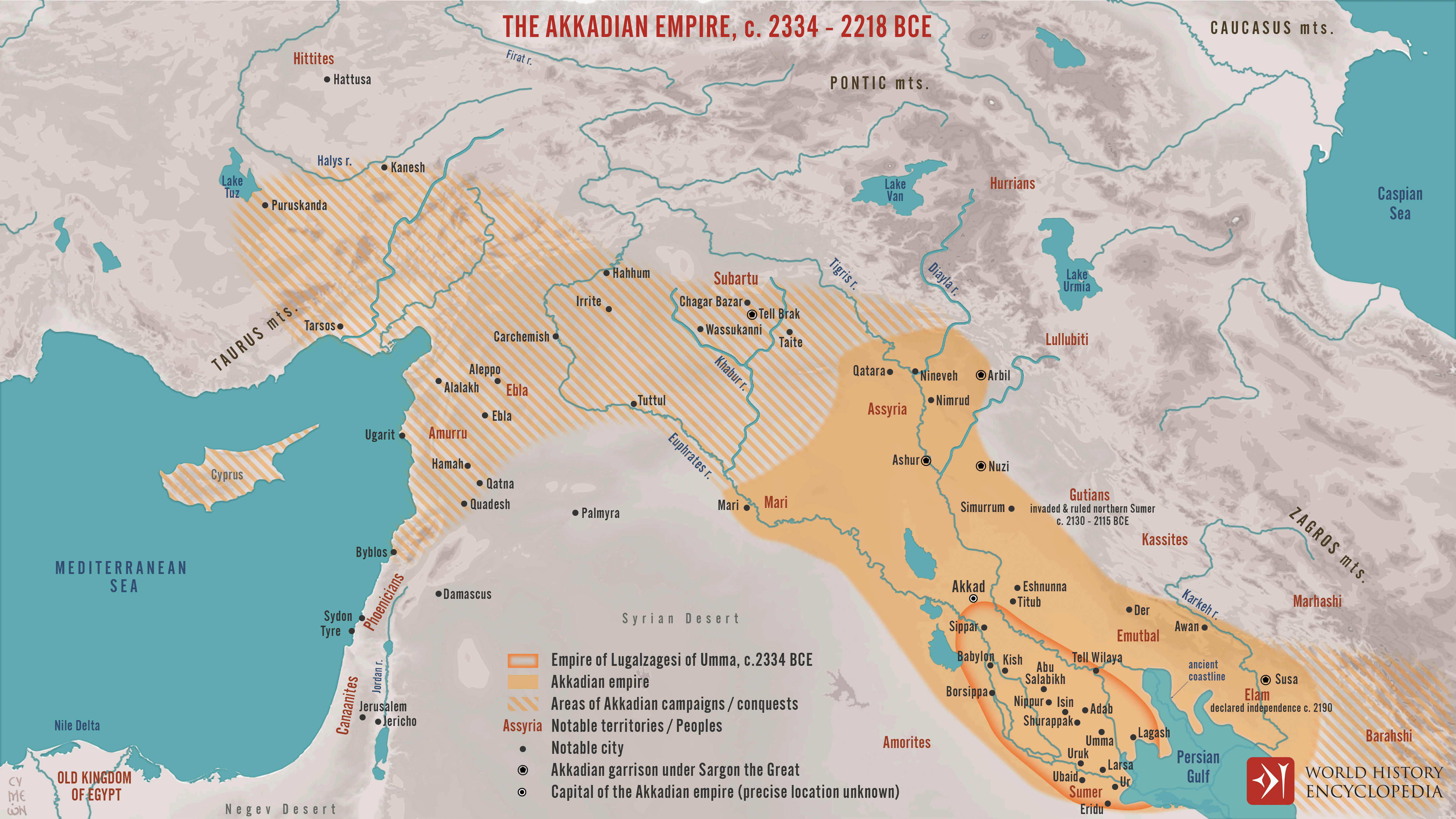
The [Akkadian Empire](https://www.worldhistory.org/akkad/) (c. 2334–2218 BCE), founded by [Sargon of Akkad](https://www.worldhistory.org/Sargon_of_Akkad/) (reign c. 2334–2279 BCE), is widely regarded as the first territorial [empire](https://www.worldhistory.org/empire/) in recorded history. Emerging from the political landscape of [Sumerian](https://www.worldhistory.org/Sumerians/) [city](https://www.worldhistory.org/city/)-states, [Sargon](https://www.worldhistory.org/disambiguation/sargon/) established control over key urban centers such as Kish, [Uruk](https://www.worldhistory.org/uruk/), and [Ur](https://www.worldhistory.org/ur/), creating a centralized system of governance supported by military garrisons and administrative officials. Under his successors, particularly [Naram-Sin](https://www.worldhistory.org/Naram-Sin/) (reign c. 2254–2218 BCE), the empire expanded further, reaching from the Persian Gulf to the [Mediterranean](https://www.worldhistory.org/disambiguation/mediterranean/), and projecting power into Upper [Mesopotamia](https://www.worldhistory.org/Mesopotamia/), the Zagros highlands, and the [Levant](https://www.worldhistory.org/levant/). This expansion relied less on fixed borders than on a network of strategic [cities](https://www.worldhistory.org/city/), tributary regions, and campaign routes.
[Akkadian](https://www.worldhistory.org/disambiguation/akkadian/) royal ideology expressed this expansion through the concept of the “four quarters of the world” (*kibrāt erbetti*), dividing the known world into [Sumer](https://www.worldhistory.org/sumer/) (south), Subartu (north), [Elam](https://www.worldhistory.org/elam/) (east), and Amurru (west). These were not administrative divisions but symbolic directions of universal rule centered on [Akkad](https://www.worldhistory.org/akkad/). Despite its achievements, the Akkadian state faced internal pressures and external challenges, including incursions by highland groups such as the [Gutians](https://www.worldhistory.org/Gutians/) and Elamites (c. 22nd century BCE), contributing to its eventual decline.
#### Editorial Review
This human-authored image has been reviewed by our editorial team before publication to ensure accuracy, reliability and adherence to academic standards in accordance with our [editorial policy](https://www.worldhistory.org/static/editorial-policy/).
## About the Author
Simeon is a freelance visual designer and history educator, passionate about the human stories that shape the past.
- [Linkedin Profile](https://www.linkedin.com/in/simeon-netchev/)
## External Links
- [The Akkadian Period (ca. 2350–2150 B.C.) | Essay | The Metropolitan Museum of Art | Heilbrunn Timeline of Art History](https://www.metmuseum.org/toah/hd/akka/hd_akka.htm)
## Cite This Work
### APA
Netchev, S. (2026, April 02). Map of the Akkadian Empire at Its Height: Ruling the Four Quarters of the World. *World History Encyclopedia*.
### Chicago
Netchev, Simeon. "Map of the Akkadian Empire at Its Height: Ruling the Four Quarters of the World." *World History Encyclopedia*, April 02, 2026. .
### MLA
Netchev, Simeon. "Map of the Akkadian Empire at Its Height: Ruling the Four Quarters of the World." *World History Encyclopedia*, 02 Apr 2026, .
## License & Copyright
Submitted by [Simeon Netchev](https://www.worldhistory.org/user/simeonnetchev/ "User Page: Simeon Netchev"), published on 02 April 2026. The copyright holder has published this content under the following license: [Creative Commons Attribution-NonCommercial-NoDerivs](https://creativecommons.org/licenses/by-nc/4.0deed.en). This licence only allows others to download this content and share it with others as long as the author is credited, but they can't change the content in any way or use it commercially. When republishing on the web a hyperlink back to the original content source URL must be included. Please note that content linked from this page may have different licensing terms.