---
title: Map of the Akkadian Empire at Its Height, c. 2250 BCE: Sargon, Naram-Sin, and the Rise of Mesopotamian Empire
author: Simeon Netchev
source: https://www.worldhistory.org/image/15457/map-of-the-akkadian-empire-at-its-height-c-2250-bc/
format: machine-readable-alternate
license: Creative Commons Attribution-NonCommercial-NoDerivs (https://creativecommons.org/licenses/by-nc/4.0)
updated: 2026-11-14
---
# Map of the Akkadian Empire at Its Height, c. 2250 BCE: Sargon, Naram-Sin, and the Rise of Mesopotamian Empire
_Authored by [Simeon Netchev](https://www.worldhistory.org/user/simeonnetchev/)_
## Image File
[](https://www.worldhistory.org/uploads/images/15457.png)
## Image Caption
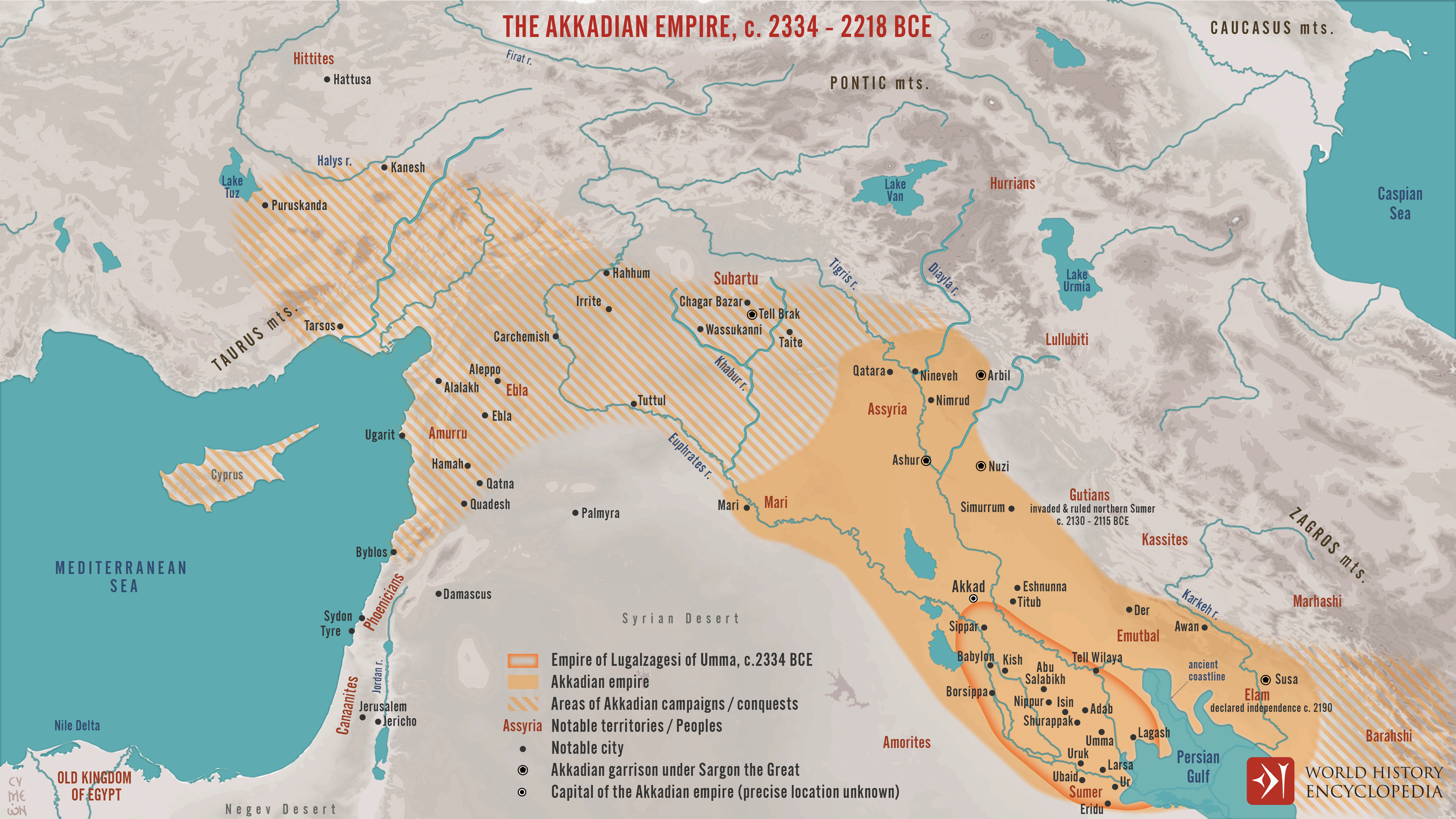
The [Akkadian Empire](https://www.worldhistory.org/akkad/) (c. 2334–2154 BCE) is widely regarded as one of the earliest territorial empires in recorded history. Founded by [Sargon of Akkad](https://www.worldhistory.org/Sargon_of_Akkad/) (reign c. 2334–2279 BCE), it emerged from the political landscape of [Sumerian](https://www.worldhistory.org/Sumerians/) [city](https://www.worldhistory.org/city/)-states, bringing major centers such as [Kish](https://www.worldhistory.org/kish/), [Uruk](https://www.worldhistory.org/uruk/), and [Ur](https://www.worldhistory.org/ur/) under one royal authority. Its expansion relied on military campaigns, strategic [cities](https://www.worldhistory.org/city/), administrative officials, and tributary relationships rather than uniformly controlled borders. Under [Naram-Sin](https://www.worldhistory.org/Naram-Sin/) (reign c. 2254–2218 BCE), [Akkadian](https://www.worldhistory.org/disambiguation/akkadian/) power reached its height, extending across [Mesopotamia](https://www.worldhistory.org/Mesopotamia/) and projecting military and political influence into northern [Syria](https://www.worldhistory.org/syria/), the Zagros highlands, and toward [Anatolia](https://www.worldhistory.org/Asia_Minor/) and the [Mediterranean](https://www.worldhistory.org/disambiguation/mediterranean/).
Akkadian royal ideology expressed these ambitions through the concept of the "four quarters of the world" (*kibrāt erbetti*), evoking [Sumer](https://www.worldhistory.org/sumer/) (south), Subartu (north), [Elam](https://www.worldhistory.org/elam/) (east), and Amurru (west). These regions represented the geographical horizons of universal kingship rather than formal administrative divisions. The [empire](https://www.worldhistory.org/empire/) connected diverse communities through [conquest](https://www.worldhistory.org/warfare/), diplomacy, [trade](https://www.worldhistory.org/disambiguation/trade/), and governance, laying foundations for later Mesopotamian imperial traditions. Following Naram-Sin's reign, internal revolts, renewed independence among subject cities, and conflicts with neighboring peoples, including the [Gutians](https://www.worldhistory.org/Gutians/), contributed to its gradual fragmentation and eventual collapse around 2154 BCE.
#### Editorial Review
This human-authored image has been reviewed by our editorial team before publication to ensure accuracy, reliability and adherence to academic standards in accordance with our [editorial policy](https://www.worldhistory.org/static/editorial-policy/).
## About the Author
Simeon is a freelance visual designer and history educator, passionate about the human stories that shape the past.
- [Linkedin Profile](https://www.linkedin.com/in/simeon-netchev/)
## External Links
- [The Akkadian Period (ca. 2350–2150 B.C.) | Essay | The Metropolitan Museum of Art | Heilbrunn Timeline of Art History](https://www.metmuseum.org/toah/hd/akka/hd_akka.htm)
## Cite This Work
### APA
Netchev, S. (2026, November 14). Map of the Akkadian Empire at Its Height, c. 2250 BCE: Sargon, Naram-Sin, and the Rise of Mesopotamian Empire. *World History Encyclopedia*.
### Chicago
Netchev, Simeon. "Map of the Akkadian Empire at Its Height, c. 2250 BCE: Sargon, Naram-Sin, and the Rise of Mesopotamian Empire." *World History Encyclopedia*, November 14, 2026. .
### MLA
Netchev, Simeon. "Map of the Akkadian Empire at Its Height, c. 2250 BCE: Sargon, Naram-Sin, and the Rise of Mesopotamian Empire." *World History Encyclopedia*, 14 Nov 2026, .
## License & Copyright
Submitted by [Simeon Netchev](https://www.worldhistory.org/user/simeonnetchev/ "User Page: Simeon Netchev"), published on 14 November 2026. The copyright holder has published this content under the following license: [Creative Commons Attribution-NonCommercial-NoDerivs](https://creativecommons.org/licenses/by-nc/4.0deed.en). This licence only allows others to download this content and share it with others as long as the author is credited, but they can't change the content in any way or use it commercially. When republishing on the web a hyperlink back to the original content source URL must be included. Please note that content linked from this page may have different licensing terms.