---
title: Map of the Late Bronze Age Collapse and Transfromation: Interconnected political, economic & environmental breakdown
author: Simeon Netchev
source: https://www.worldhistory.org/image/15310/map-of-the-late-bronze-age-collapse-and-transfroma/
format: machine-readable-alternate
license: Creative Commons Attribution-NonCommercial-NoDerivs (https://creativecommons.org/licenses/by-nc/4.0)
updated: 2026-07-15
---
# Map of the Late Bronze Age Collapse and Transfromation: Interconnected political, economic & environmental breakdown
_Authored by [Simeon Netchev](https://www.worldhistory.org/user/simeonnetchev/)_
## Image File
[](https://www.worldhistory.org/uploads/images/15310.png)
## Image Caption
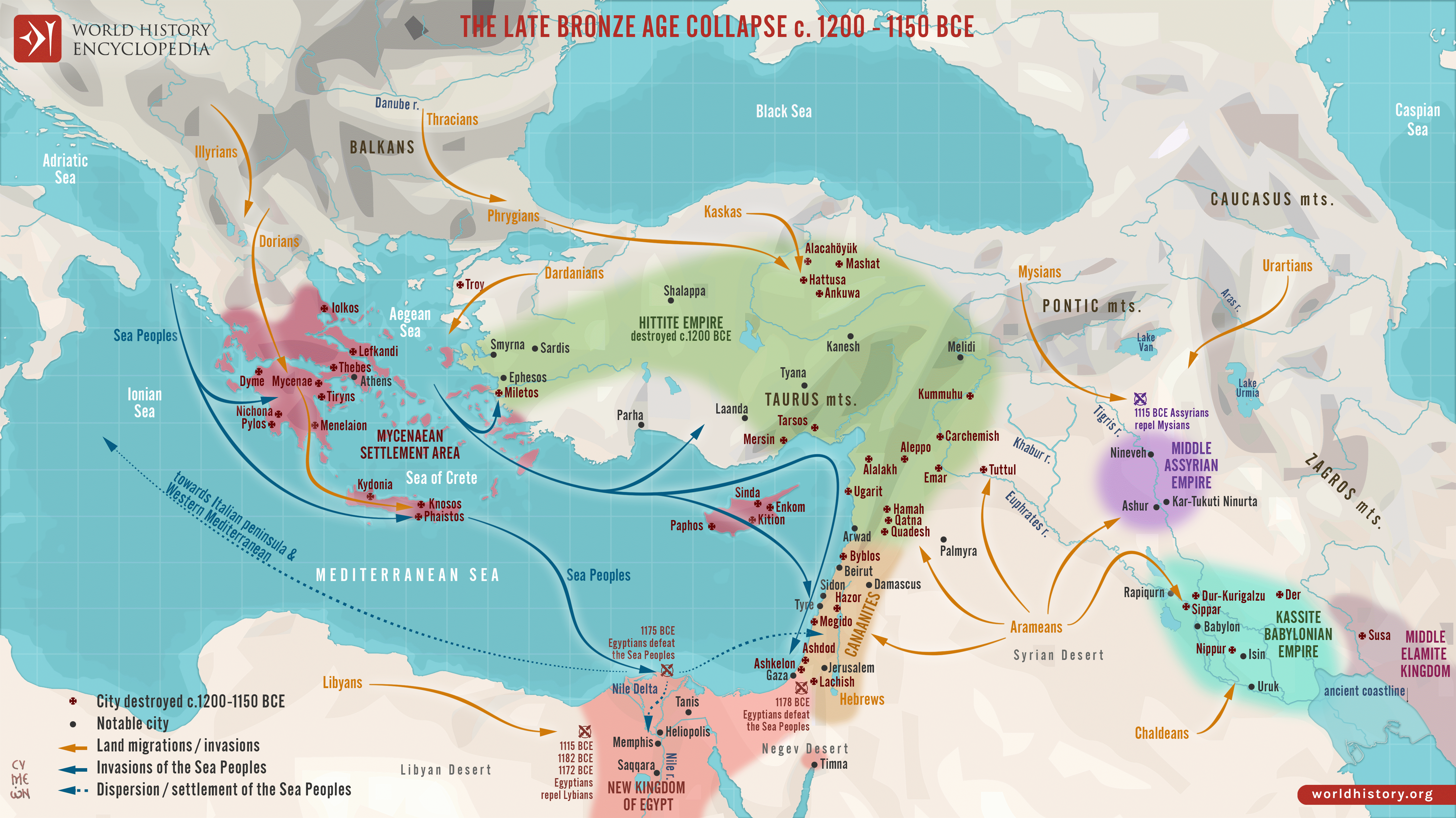
The Late [Bronze Age Collapse](https://www.worldhistory.org/Bronze_Age_Collapse/) and Transformation (c. 1250–1100 BCE) was a period of major political, economic, and social disruption across the [Aegean](https://www.worldhistory.org/aegean/), Eastern [Mediterranean](https://www.worldhistory.org/disambiguation/mediterranean/), [Anatolia](https://www.worldhistory.org/Asia_Minor/), and [Mesopotamia](https://www.worldhistory.org/Mesopotamia/). Highly interconnected [palace](https://www.worldhistory.org/disambiguation/palace/)-based states, dependent on centralized administration, agricultural surplus, and long-distance exchange, proved vulnerable as these systems weakened. The [Mycenaean](https://www.worldhistory.org/Mycenaean_Civilization/) palatial states disintegrated (c. 1200–1150 BCE), the [Hittite](https://www.worldhistory.org/hittite/) imperial system dissolved following the evacuation and abandonment of Hattusa (c. 1200–1180 BCE), and the [Kassite](https://www.worldhistory.org/kassite/) dynasty in [Babylonia](https://www.worldhistory.org/babylon/) ended after [Elamite](https://www.worldhistory.org/elam/) invasion (c. 1155 BCE). [New Kingdom](https://www.worldhistory.org/disambiguation/New_Kingdom/) [Egypt](https://www.worldhistory.org/egypt/) (c. 1550–1070 BCE), although it repelled major external threats under [Ramesses](https://www.worldhistory.org/disambiguation/ramesses/) III (reign c. 1186–1155 BCE), entered a period of internal crisis and imperial retrenchment.
The transformation resulted not from a single cause but from the convergence of long-term structural pressures. Episodes of aridity and climatic instability (c. 1250–1100 BCE) intensified existing weaknesses by reducing agricultural surplus and state revenues, while political instability, disruption of [copper](https://www.worldhistory.org/copper/) and tin networks, and the decline of redistributive palace economies further undermined regional resilience. Population movements, [warfare](https://www.worldhistory.org/warfare/), and maritime raids associated with groups conventionally called the [Sea Peoples](https://www.worldhistory.org/Sea_Peoples/) increased instability across coastal regions (c. 1200–1175 BCE), contributing to the destruction of centres such as [Ugarit](https://www.worldhistory.org/ugarit/) (c. 1190 BCE).
#### Editorial Review
This human-authored image has been reviewed by our editorial team before publication to ensure accuracy, reliability and adherence to academic standards in accordance with our [editorial policy](https://www.worldhistory.org/static/editorial-policy/).
## About the Author
Simeon is a freelance visual designer and history educator, passionate about the human stories that shape the past.
- [Linkedin Profile](https://www.linkedin.com/in/simeon-netchev/)
## Cite This Work
### APA
Netchev, S. (2026, July 15). Map of the Late Bronze Age Collapse and Transfromation: Interconnected political, economic & environmental breakdown. *World History Encyclopedia*.
### Chicago
Netchev, Simeon. "Map of the Late Bronze Age Collapse and Transfromation: Interconnected political, economic & environmental breakdown." *World History Encyclopedia*, July 15, 2026. .
### MLA
Netchev, Simeon. "Map of the Late Bronze Age Collapse and Transfromation: Interconnected political, economic & environmental breakdown." *World History Encyclopedia*, 15 Jul 2026, .
## License & Copyright
Submitted by [Simeon Netchev](https://www.worldhistory.org/user/simeonnetchev/ "User Page: Simeon Netchev"), published on 15 July 2026. The copyright holder has published this content under the following license: [Creative Commons Attribution-NonCommercial-NoDerivs](https://creativecommons.org/licenses/by-nc/4.0deed.en). This licence only allows others to download this content and share it with others as long as the author is credited, but they can't change the content in any way or use it commercially. When republishing on the web a hyperlink back to the original content source URL must be included. Please note that content linked from this page may have different licensing terms.