---
title: Map of the Battlefield of the Trojan War c. 1200 BCE: Landscape of the Iliad
author: Simeon Netchev
source: https://www.worldhistory.org/image/15243/map-of-the-battlefield-of-the-trojan-war-c-1200-bc/
format: machine-readable-alternate
license: Creative Commons Attribution-NonCommercial-NoDerivs (https://creativecommons.org/licenses/by-nc/4.0)
updated: 2026-03-07
---
# Map of the Battlefield of the Trojan War c. 1200 BCE: Landscape of the Iliad
_Authored by [Simeon Netchev](https://www.worldhistory.org/user/simeonnetchev/)_
## Image File
[](https://www.worldhistory.org/uploads/images/15243.png)
## Image Caption
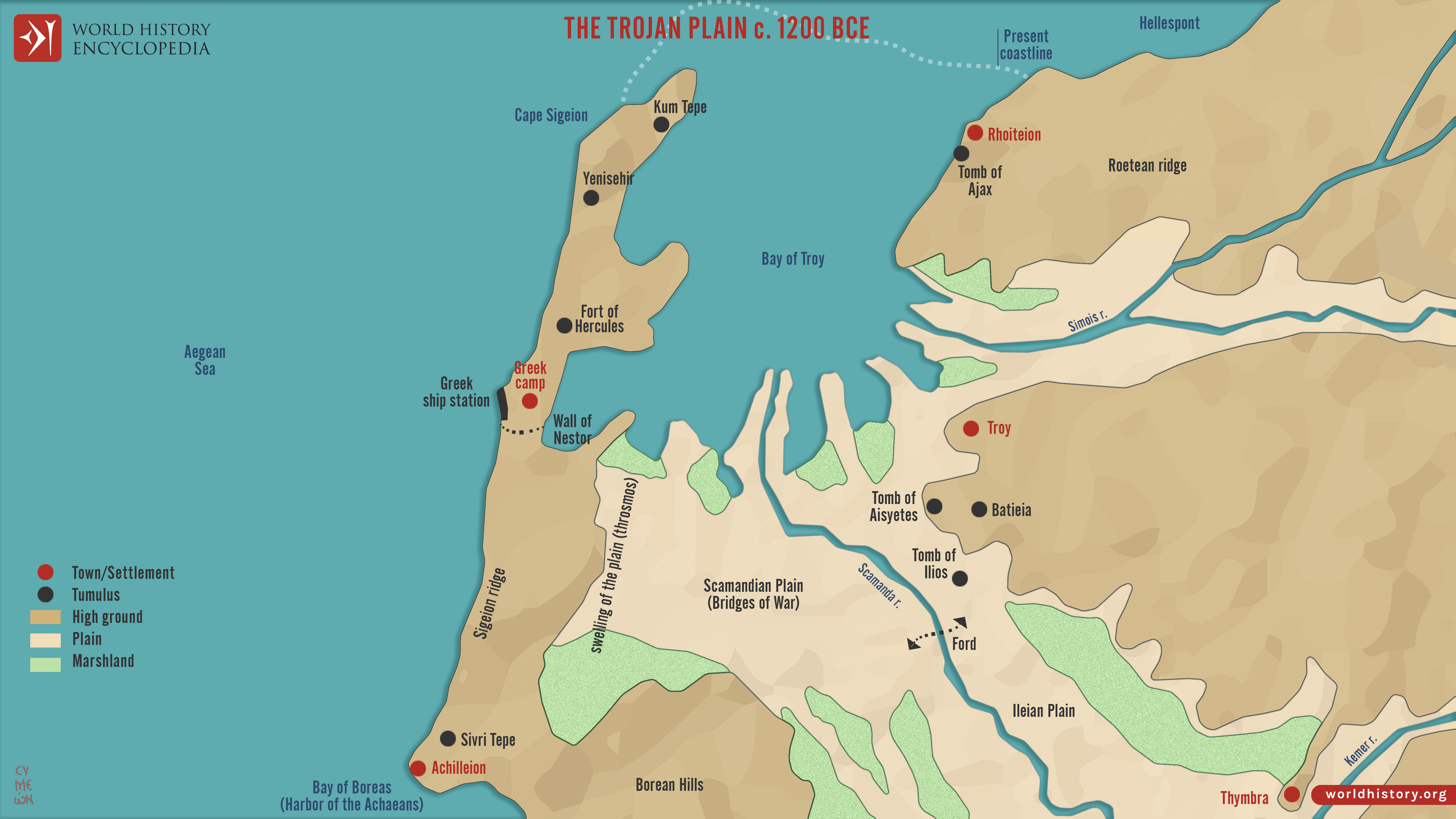
The battlefield traditionally associated with the [Trojan War](https://www.worldhistory.org/Trojan_War/) is described in the *[Iliad](https://www.worldhistory.org/iliad/)*, attributed to [Homer](https://www.worldhistory.org/homer/) (traditionally dated c. 8th century BCE). The narrative situates the conflict between the Achaean coalition and the defenders of [Troy](https://www.worldhistory.org/troy/) on the coastal plain below the fortified [city](https://www.worldhistory.org/city/), widely identified with the archaeological site of Troy (Hisarlık) in northwestern [Anatolia](https://www.worldhistory.org/Asia_Minor/), near the Dardanelles. In the Late [Bronze Age](https://www.worldhistory.org/disambiguation/Bronze_Age/) context (c. 1600–1200 BCE), the shoreline lay significantly closer to the city than today due to later sediment accumulation. The plain described in the epic stretches from Troy’s walls to the Achaean camp and ships along the coast, forming the central arena for many of the battles narrated in the poem.
Modern geological and archaeological research, including sediment analysis of the Scamander River and Simois River systems, has helped reconstruct the Late [Bronze](https://www.worldhistory.org/disambiguation/bronze/) Age landscape around c. 1200 BCE. These studies suggest the presence of a dynamic river delta with marshlands and shifting channels that would have influenced movement and combat on the plain, broadly consistent with Homeric descriptions. The era corresponds to the wider [Bronze Age Collapse](https://www.worldhistory.org/Bronze_Age_Collapse/) (c. 1200–1150 BCE), a period of widespread upheaval across the eastern [Mediterranean](https://www.worldhistory.org/disambiguation/mediterranean/). Whether the Trojan [War](https://www.worldhistory.org/disambiguation/War/) reflects a historical conflict, a composite memory of regional struggles, or a mythic tradition shaped by later storytelling, the geography of the Troad provides an environmental framework through which the epic narrative can be interpreted.
#### Editorial Review
This human-authored image has been reviewed by our editorial team before publication to ensure accuracy, reliability and adherence to academic standards in accordance with our [editorial policy](https://www.worldhistory.org/static/editorial-policy/).
## About the Author
Simeon is a freelance visual designer and history educator, passionate about the human stories that shape the past.
- [Linkedin Profile](https://www.linkedin.com/in/simeon-netchev/)
## Cite This Work
### APA
Netchev, S. (2026, March 07). Map of the Battlefield of the Trojan War c. 1200 BCE: Landscape of the Iliad. *World History Encyclopedia*.
### Chicago
Netchev, Simeon. "Map of the Battlefield of the Trojan War c. 1200 BCE: Landscape of the Iliad." *World History Encyclopedia*, March 07, 2026. .
### MLA
Netchev, Simeon. "Map of the Battlefield of the Trojan War c. 1200 BCE: Landscape of the Iliad." *World History Encyclopedia*, 07 Mar 2026, .
## License & Copyright
Submitted by [Simeon Netchev](https://www.worldhistory.org/user/simeonnetchev/ "User Page: Simeon Netchev"), published on 07 March 2026. The copyright holder has published this content under the following license: [Creative Commons Attribution-NonCommercial-NoDerivs](https://creativecommons.org/licenses/by-nc/4.0deed.en). This licence only allows others to download this content and share it with others as long as the author is credited, but they can't change the content in any way or use it commercially. When republishing on the web a hyperlink back to the original content source URL must be included. Please note that content linked from this page may have different licensing terms.