---
title: Map of Tthe Ancient Near East c. 1700 BCE: The Old Assyrian Empire - between cities and kingdoms
author: Simeon Netchev
source: https://www.worldhistory.org/image/15146/map-of-tthe-ancient-near-east-c-1700-bce/
format: machine-readable-alternate
license: Creative Commons Attribution-NonCommercial-NoDerivs (https://creativecommons.org/licenses/by-nc/4.0)
updated: 2026-01-02
---
# Map of Tthe Ancient Near East c. 1700 BCE: The Old Assyrian Empire - between cities and kingdoms
_Authored by [Simeon Netchev](https://www.worldhistory.org/user/simeonnetchev/)_
## Image File
[](https://www.worldhistory.org/uploads/images/15146.png)
## Image Caption
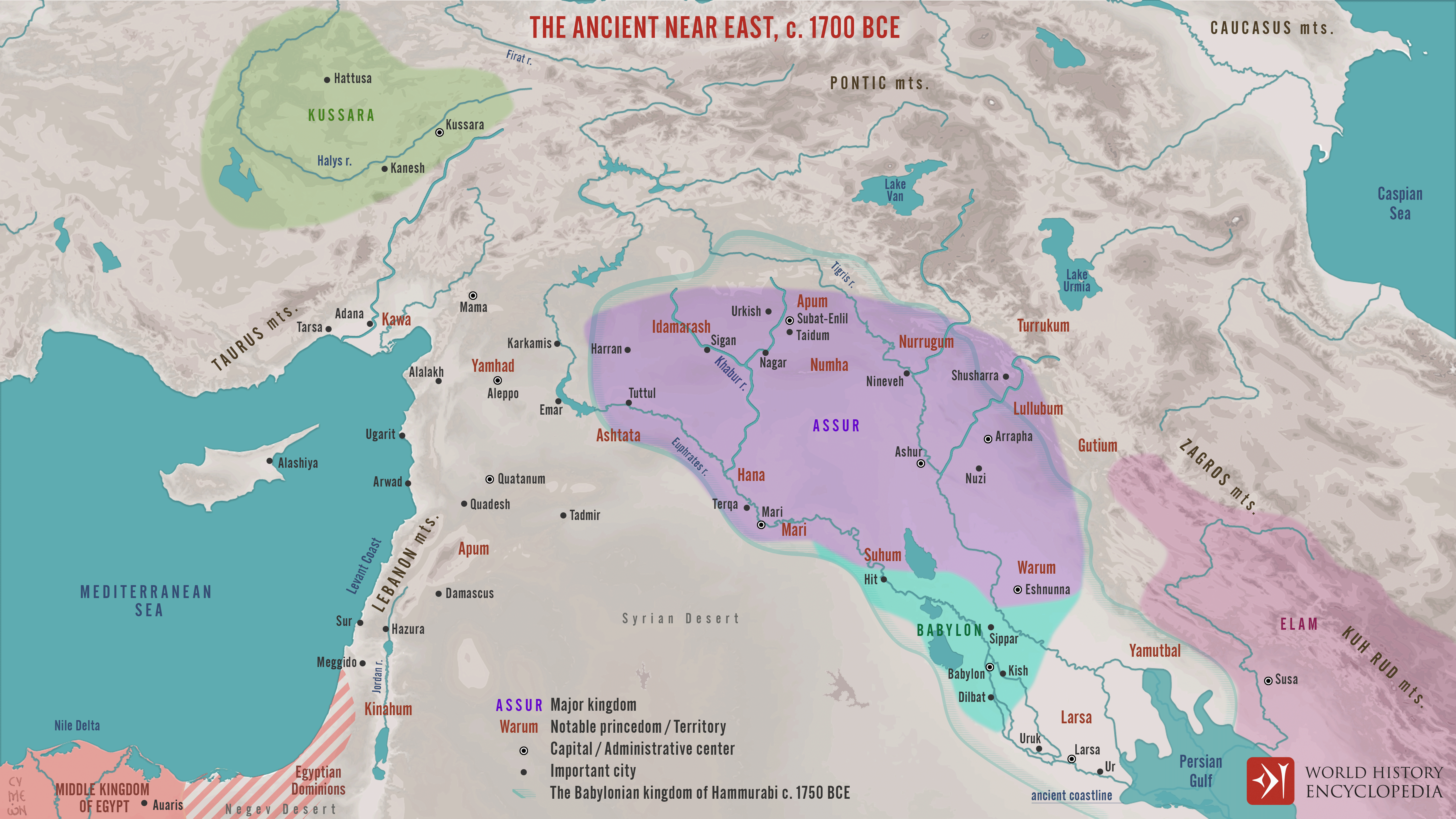
Around c. 1700 BCE, the Ancient [Near East](https://www.worldhistory.org/Near_East/) was a politically fragmented but highly interconnected region, shaped by shifting alliances, commercial networks, and emerging territorial states. This period corresponds to the Old Assyrian era and precedes the full consolidation of power in southern [Mesopotamia](https://www.worldhistory.org/Mesopotamia/) under [Hammurabi](https://www.worldhistory.org/hammurabi/) of [Babylon](https://www.worldhistory.org/babylon/) (reign c. 1792–1750 BCE). Rather than a single dominant [empire](https://www.worldhistory.org/empire/), the landscape was defined by competing [city](https://www.worldhistory.org/city/)-states and kingdoms whose influence rested on [trade](https://www.worldhistory.org/disambiguation/trade/), diplomacy, and military opportunism.
In Upper Mesopotamia, the [city-state](https://www.worldhistory.org/Polis/) of [Assur](https://www.worldhistory.org/assur/), situated on the Upper Tigris, was transitioning from a mercantile hub into a more assertive political power. Assyrian merchants operated extensive long-distance trade networks, most notably through colonies such as Kanesh (Kültepe) in [Anatolia](https://www.worldhistory.org/Asia_Minor/), linking Mesopotamia with [metal](https://www.worldhistory.org/disambiguation/metal/)-producing regions to the north. At the same time, central Anatolia witnessed early political consolidation under Anitta of Kussara (reign c. 1740 BCE), a precursor to the Early [Hittite](https://www.worldhistory.org/hittite/) state. Elsewhere, established powers such as [Mari](https://www.worldhistory.org/mari/) under Zimri-Lim (reign c. 1775–1761 BCE) and Eshnunna were weakening, while Babylon, under Hammurabi, was poised to exploit this instability. Together, these developments marked a critical transitional moment, setting the stage for new imperial formations that would reshape the Near Eastern political order in the decades that followed.
#### Editorial Review
This human-authored image has been reviewed by our editorial team before publication to ensure accuracy, reliability and adherence to academic standards in accordance with our [editorial policy](https://www.worldhistory.org/static/editorial-policy/).
## About the Author
Simeon is a freelance visual designer and history educator, passionate about the human stories that shape the past.
- [Linkedin Profile](https://www.linkedin.com/in/simeon-netchev/)
## Cite This Work
### APA
Netchev, S. (2022, January 18). Map of Tthe Ancient Near East c. 1700 BCE: The Old Assyrian Empire - between cities and kingdoms. *World History Encyclopedia*.
### Chicago
Netchev, Simeon. "Map of Tthe Ancient Near East c. 1700 BCE: The Old Assyrian Empire - between cities and kingdoms." *World History Encyclopedia*, January 18, 2022. .
### MLA
Netchev, Simeon. "Map of Tthe Ancient Near East c. 1700 BCE: The Old Assyrian Empire - between cities and kingdoms." *World History Encyclopedia*, 18 Jan 2022, .
## License & Copyright
Submitted by [Simeon Netchev](https://www.worldhistory.org/user/simeonnetchev/ "User Page: Simeon Netchev"), published on 18 January 2022. The copyright holder has published this content under the following license: [Creative Commons Attribution-NonCommercial-NoDerivs](https://creativecommons.org/licenses/by-nc/4.0deed.en). This licence only allows others to download this content and share it with others as long as the author is credited, but they can't change the content in any way or use it commercially. When republishing on the web a hyperlink back to the original content source URL must be included. Please note that content linked from this page may have different licensing terms.