---
title: Map of Elizabethan Trade with Europe, c. 1600: Trade and Diplomacy in the Tudor World
author: Simeon Netchev
source: https://www.worldhistory.org/image/14997/map-of-elizabethan-trade-with-europe-c-1600/
format: machine-readable-alternate
license: Creative Commons Attribution-NonCommercial-NoDerivs (https://creativecommons.org/licenses/by-nc/4.0)
updated: 2026-02-16
---
# Map of Elizabethan Trade with Europe, c. 1600: Trade and Diplomacy in the Tudor World
_Authored by [Simeon Netchev](https://www.worldhistory.org/user/simeonnetchev/)_
## Image File
[](https://www.worldhistory.org/uploads/images/14997.png)
## Image Caption
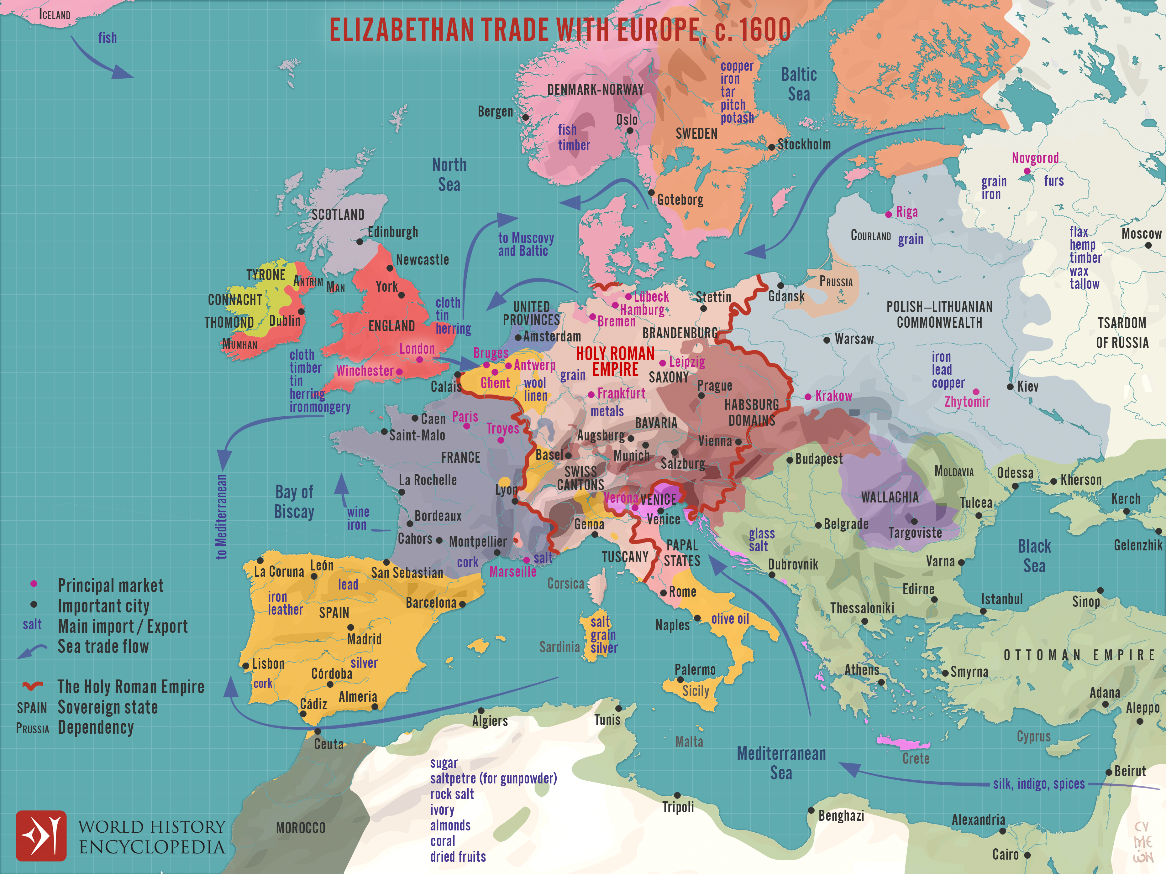
During the reign of Queen Elizabeth I (reign 1558–1603), [England](https://www.worldhistory.org/disambiguation/england/) underwent a decisive commercial transformation, expanding its [trade](https://www.worldhistory.org/disambiguation/trade/) networks across northern and southern [Europe](https://www.worldhistory.org/europe/) at a moment of shifting geopolitical and economic balance. The later 16th century witnessed the gradual erosion of the [Hanseatic League](https://www.worldhistory.org/Hanseatic_League/)’s dominance in the Baltic, the rise of Amsterdam as a dynamic commercial hub, and the increasing integration of Atlantic and [Mediterranean](https://www.worldhistory.org/disambiguation/mediterranean/) markets. English merchants, supported by the Crown through charters and diplomatic negotiation, extended their reach across the North Sea, the Baltic, [Iberia](https://www.worldhistory.org/disambiguation/iberia/), and the [Levant](https://www.worldhistory.org/levant/), positioning England as an emerging maritime trading power rather than a peripheral kingdom on Europe’s edge.
This expansion was institutionalized through chartered companies such as the Muscovy Company (founded 1555), Eastland Company (1579), Levant Company (1581), and [East India Company](https://www.worldhistory.org/East_India_Company/) (1600), which organized risk, secured monopolies, and linked England to continental and global circuits of exchange. English exports, especially wool and finished cloth, were exchanged for grain, naval stores, timber, wine, metals, and furs, while Mediterranean and Atlantic intermediaries connected England to wider flows of [silk](https://www.worldhistory.org/Silk/), spices, sugar, and precious commodities from Asia, [Africa](https://www.worldhistory.org/disambiguation/africa/), and the Americas. These developments did not yet constitute a global [empire](https://www.worldhistory.org/empire/), but they laid the structural foundations, financial, naval, and institutional, for England’s later imperial and commercial ascendancy in the 17th century.
#### Editorial Review
This human-authored image has been reviewed by our editorial team before publication to ensure accuracy, reliability and adherence to academic standards in accordance with our [editorial policy](https://www.worldhistory.org/static/editorial-policy/).
## About the Author
Simeon is a freelance visual designer and history educator, passionate about the human stories that shape the past.
- [Linkedin Profile](https://www.linkedin.com/in/simeon-netchev/)
## External Links
- [Medieval Trade Routes Map](https://easyzoom.com/image/218139)
## Cite This Work
### APA
Netchev, S. (2026, February 16). Map of Elizabethan Trade with Europe, c. 1600: Trade and Diplomacy in the Tudor World. *World History Encyclopedia*.
### Chicago
Netchev, Simeon. "Map of Elizabethan Trade with Europe, c. 1600: Trade and Diplomacy in the Tudor World." *World History Encyclopedia*, February 16, 2026. .
### MLA
Netchev, Simeon. "Map of Elizabethan Trade with Europe, c. 1600: Trade and Diplomacy in the Tudor World." *World History Encyclopedia*, 16 Feb 2026, .
## License & Copyright
Submitted by [Simeon Netchev](https://www.worldhistory.org/user/simeonnetchev/ "User Page: Simeon Netchev"), published on 16 February 2026. The copyright holder has published this content under the following license: [Creative Commons Attribution-NonCommercial-NoDerivs](https://creativecommons.org/licenses/by-nc/4.0deed.en). This licence only allows others to download this content and share it with others as long as the author is credited, but they can't change the content in any way or use it commercially. When republishing on the web a hyperlink back to the original content source URL must be included. Please note that content linked from this page may have different licensing terms.