---
title: Map of the The Mitanni (Hanigalbat) empire, c. 1600-1300 BCE: Between Egypt and the Hittites, A Kingdom of Diplomacy and War
author: Simeon Netchev
source: https://www.worldhistory.org/image/14946/map-of-the-the-mitanni-hanigalbat-empire-c-1600-13/
format: machine-readable-alternate
license: Creative Commons Attribution-NonCommercial-NoDerivs (https://creativecommons.org/licenses/by-nc/4.0)
updated: 2026-01-15
---
# Map of the The Mitanni (Hanigalbat) empire, c. 1600-1300 BCE: Between Egypt and the Hittites, A Kingdom of Diplomacy and War
_Authored by [Simeon Netchev](https://www.worldhistory.org/user/simeonnetchev/)_
## Image File
[](https://www.worldhistory.org/uploads/images/14946.png)
## Image Caption
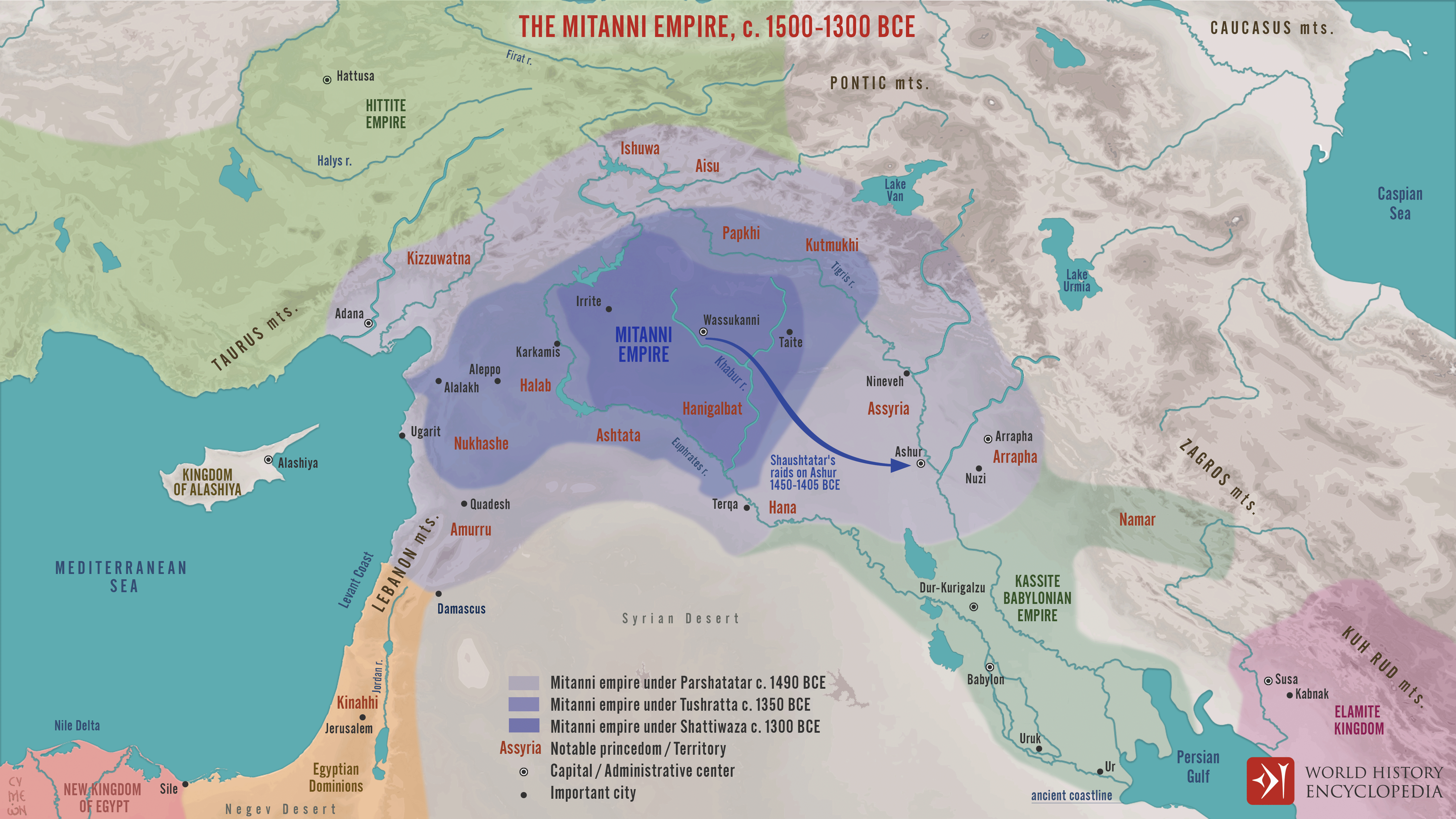
The [Mitanni](https://www.worldhistory.org/Mitanni/) [Empire](https://www.worldhistory.org/empire/) was a major Late [Bronze Age](https://www.worldhistory.org/disambiguation/Bronze_Age/) power that rose in northern [Mesopotamia](https://www.worldhistory.org/Mesopotamia/) and Upper [Syria](https://www.worldhistory.org/syria/) between c. 1600 and 1300 BCE, shaping the balance of power across the eastern [Mediterranean](https://www.worldhistory.org/disambiguation/mediterranean/) world. Emerging in the political vacuum following the collapse of Old Babylonian authority, Mitanni reached its height in the 15th century BCE, functioning as a strategic intermediary between rival great powers, [New Kingdom](https://www.worldhistory.org/disambiguation/New_Kingdom/) [Egypt](https://www.worldhistory.org/egypt/) (especially under [Thutmose III](https://www.worldhistory.org/Thutmose_III/), reign c. 1479–1425 BCE), the [Hittite](https://www.worldhistory.org/hittite/) Empire, and [Kassite](https://www.worldhistory.org/kassite/) [Babylonia](https://www.worldhistory.org/babylon/). Through diplomacy, dynastic marriages, and military pressure, Mitanni helped stabilize long-distance exchange routes linking [Anatolia](https://www.worldhistory.org/Asia_Minor/), Mesopotamia, and the [Levant](https://www.worldhistory.org/levant/).
Mitanni’s core lay in the Khabur River basin (modern northeastern Syria), where a predominantly Hurrian population was ruled by an elite whose royal names, treaties, and religious vocabulary reveal Indo-[Aryan](https://www.worldhistory.org/Aryan/) influences, particularly in horse training and warrior ideology. This hybrid political [culture](https://www.worldhistory.org/disambiguation/culture/) underpinned Mitanni’s military strength but also exposed its fragility. From the 14th century BCE, sustained pressure from the resurgent [Hittites](https://www.worldhistory.org/hittite/) (notably under Šuppiluliuma I, reign c. 1344–1322 BCE) and the expanding Middle Assyrian state eroded Mitanni authority. Internal dynastic struggles further weakened the kingdom, leading to its fragmentation and eventual absorption into Assyrian and Hittite spheres by c. 1300 BCE. Mitanni’s rise and fall illustrate the volatility of Late [Bronze](https://www.worldhistory.org/disambiguation/bronze/) Age geopolitics, where power depended less on territorial size than on diplomacy, military specialization, and control of strategic corridors.
#### Editorial Review
This human-authored image has been reviewed by our editorial team before publication to ensure accuracy, reliability and adherence to academic standards in accordance with our [editorial policy](https://www.worldhistory.org/static/editorial-policy/).
## About the Author
Simeon is a freelance visual designer and history educator, passionate about the human stories that shape the past.
- [Linkedin Profile](https://www.linkedin.com/in/simeon-netchev/)
## Cite This Work
### APA
Netchev, S. (2026, January 15). Map of the The Mitanni (Hanigalbat) empire, c. 1600-1300 BCE: Between Egypt and the Hittites, A Kingdom of Diplomacy and War. *World History Encyclopedia*.
### Chicago
Netchev, Simeon. "Map of the The Mitanni (Hanigalbat) empire, c. 1600-1300 BCE: Between Egypt and the Hittites, A Kingdom of Diplomacy and War." *World History Encyclopedia*, January 15, 2026. .
### MLA
Netchev, Simeon. "Map of the The Mitanni (Hanigalbat) empire, c. 1600-1300 BCE: Between Egypt and the Hittites, A Kingdom of Diplomacy and War." *World History Encyclopedia*, 15 Jan 2026, .
## License & Copyright
Submitted by [Simeon Netchev](https://www.worldhistory.org/user/simeonnetchev/ "User Page: Simeon Netchev"), published on 15 January 2026. The copyright holder has published this content under the following license: [Creative Commons Attribution-NonCommercial-NoDerivs](https://creativecommons.org/licenses/by-nc/4.0deed.en). This licence only allows others to download this content and share it with others as long as the author is credited, but they can't change the content in any way or use it commercially. When republishing on the web a hyperlink back to the original content source URL must be included. Please note that content linked from this page may have different licensing terms.