---
title: Map of Trade Networks of the Late Bronze Age Mediterranean: Empires, Merchants, and Maritime Routes of the Ancient World
author: Simeon Netchev
source: https://www.worldhistory.org/image/14880/map-of-trade-networks-of-the-late-bronze-age-medit/
format: machine-readable-alternate
license: Creative Commons Attribution-NonCommercial-NoDerivs (https://creativecommons.org/licenses/by-nc/4.0)
updated: 2026-03-10
---
# Map of Trade Networks of the Late Bronze Age Mediterranean: Empires, Merchants, and Maritime Routes of the Ancient World
_Authored by [Simeon Netchev](https://www.worldhistory.org/user/simeonnetchev/)_
## Image File
[](https://www.worldhistory.org/uploads/images/14880.png)
## Image Caption
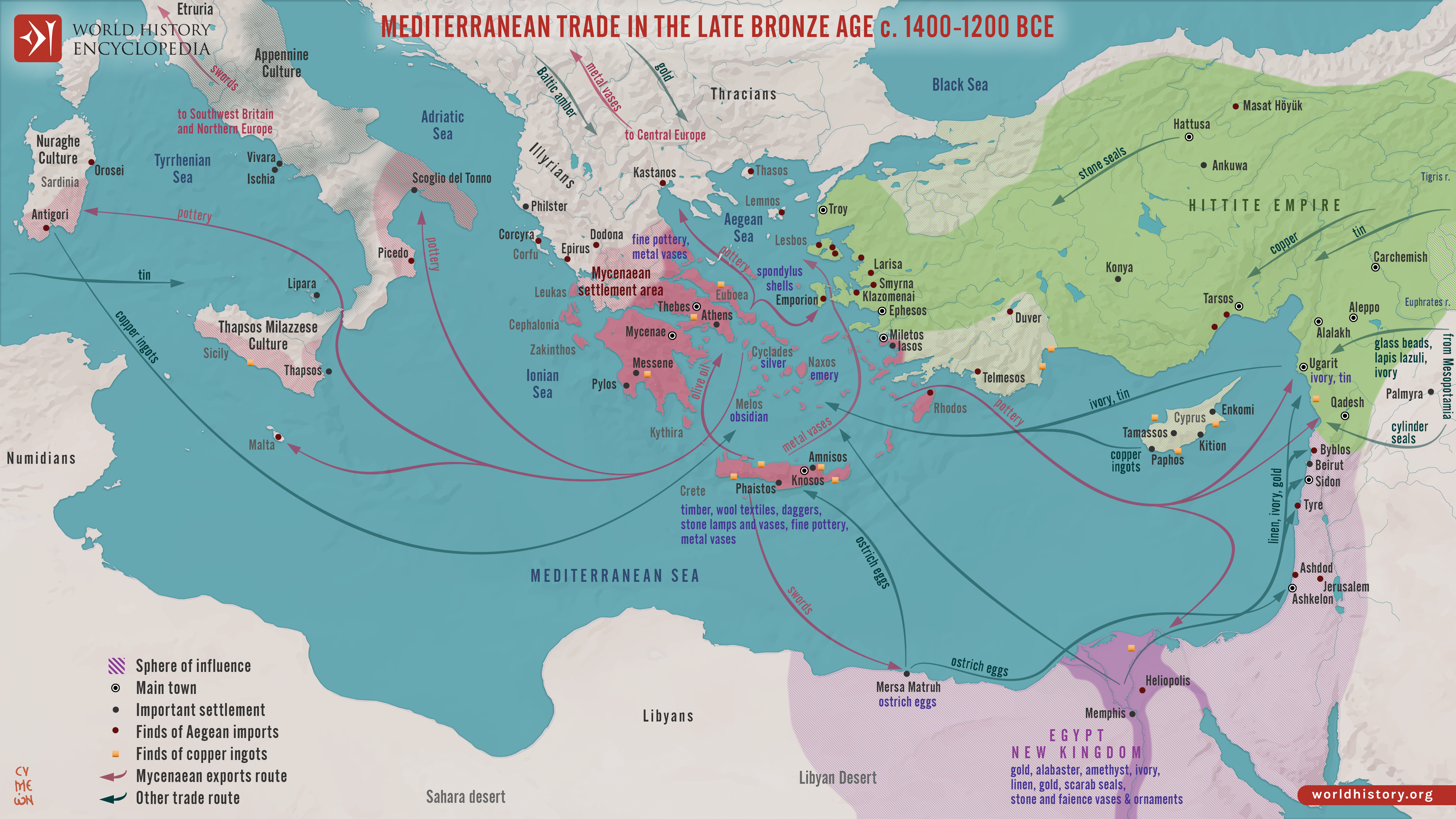
The Late [Bronze Age](https://www.worldhistory.org/disambiguation/Bronze_Age/) eastern [Mediterranean](https://www.worldhistory.org/disambiguation/mediterranean/) (c. 1500–1200 BCE) was marked by an unprecedented level of diplomatic and commercial interdependence among regional powers. Great kingdoms, including [New Kingdom](https://www.worldhistory.org/disambiguation/New_Kingdom/) [Egypt](https://www.worldhistory.org/egypt/) (c. 1550–1077 BCE), the [Hittite](https://www.worldhistory.org/hittite/) [Empire](https://www.worldhistory.org/empire/) (c. 1650–1190 BCE), the [Kassite](https://www.worldhistory.org/kassite/) rulers of [Babylon](https://www.worldhistory.org/babylon/) (c. 1595–1155 BCE), and the [Mycenaean](https://www.worldhistory.org/Mycenaean_Civilization/) [palace](https://www.worldhistory.org/disambiguation/palace/) states (c. 1600–1100 BCE), were linked through maritime routes, overland corridors, and formalized royal correspondence. The [Amarna Letters](https://www.worldhistory.org/Amarna_Letters/) (14th century BCE), exchanged during the reign of [Amenhotep III](https://www.worldhistory.org/Amenhotep_III/) (eign c. 1390–1353 BCE) and [Akhenaten](https://www.worldhistory.org/Akhenaten/) (reign c. 1353–1336 BCE), reveal a diplomatic [culture](https://www.worldhistory.org/disambiguation/culture/) grounded in gift exchange, marriage alliances, and negotiated balance-of-power politics.
This interconnected system depended on the circulation of strategic resources, tin for [bronze](https://www.worldhistory.org/disambiguation/bronze/) production, [copper](https://www.worldhistory.org/copper/) from [Cyprus](https://www.worldhistory.org/cyprus/), grain from the [Nile](https://www.worldhistory.org/nile/) Valley, textiles, luxury goods, and crafted prestige items, alongside the movement of technological knowledge and religious ideas. Levantine port [cities](https://www.worldhistory.org/city/) functioned as key intermediaries, while Mycenaean traders integrated [Aegean](https://www.worldhistory.org/aegean/) networks into broader Near Eastern exchange systems. Yet this dense web of connectivity also generated fragility: by c. 1200 BCE, internal instability, shifting [trade](https://www.worldhistory.org/disambiguation/trade/) patterns, environmental pressures, and external invasions converged in a widespread disruption often termed the Late [Bronze Age Collapse](https://www.worldhistory.org/Bronze_Age_Collapse/).
#### Editorial Review
This human-authored image has been reviewed by our editorial team before publication to ensure accuracy, reliability and adherence to academic standards in accordance with our [editorial policy](https://www.worldhistory.org/static/editorial-policy/).
## About the Author
Simeon is a freelance visual designer and history educator, passionate about the human stories that shape the past.
- [Linkedin Profile](https://www.linkedin.com/in/simeon-netchev/)
## Cite This Work
### APA
Netchev, S. (2021, November 19). Map of Trade Networks of the Late Bronze Age Mediterranean: Empires, Merchants, and Maritime Routes of the Ancient World. *World History Encyclopedia*.
### Chicago
Netchev, Simeon. "Map of Trade Networks of the Late Bronze Age Mediterranean: Empires, Merchants, and Maritime Routes of the Ancient World." *World History Encyclopedia*, November 19, 2021. .
### MLA
Netchev, Simeon. "Map of Trade Networks of the Late Bronze Age Mediterranean: Empires, Merchants, and Maritime Routes of the Ancient World." *World History Encyclopedia*, 19 Nov 2021, .
## License & Copyright
Submitted by [Simeon Netchev](https://www.worldhistory.org/user/simeonnetchev/ "User Page: Simeon Netchev"), published on 19 November 2021. The copyright holder has published this content under the following license: [Creative Commons Attribution-NonCommercial-NoDerivs](https://creativecommons.org/licenses/by-nc/4.0deed.en). This licence only allows others to download this content and share it with others as long as the author is credited, but they can't change the content in any way or use it commercially. When republishing on the web a hyperlink back to the original content source URL must be included. Please note that content linked from this page may have different licensing terms.