---
title: Map of the Late Bronze Age Mediterranean Trade Networks: Trade, Diplomacy & Interdependence, c. 1400–1200 BCE
author: Simeon Netchev
source: https://www.worldhistory.org/image/14880/map-of-the-late-bronze-age-mediterranean-trade-net/
format: machine-readable-alternate
license: Creative Commons Attribution-NonCommercial-NoDerivs (https://creativecommons.org/licenses/by-nc/4.0)
updated: 2026-09-27
---
# Map of the Late Bronze Age Mediterranean Trade Networks: Trade, Diplomacy & Interdependence, c. 1400–1200 BCE
_Authored by [Simeon Netchev](https://www.worldhistory.org/user/simeonnetchev/)_
## Image File
[](https://www.worldhistory.org/uploads/images/14880.png)
## Image Caption
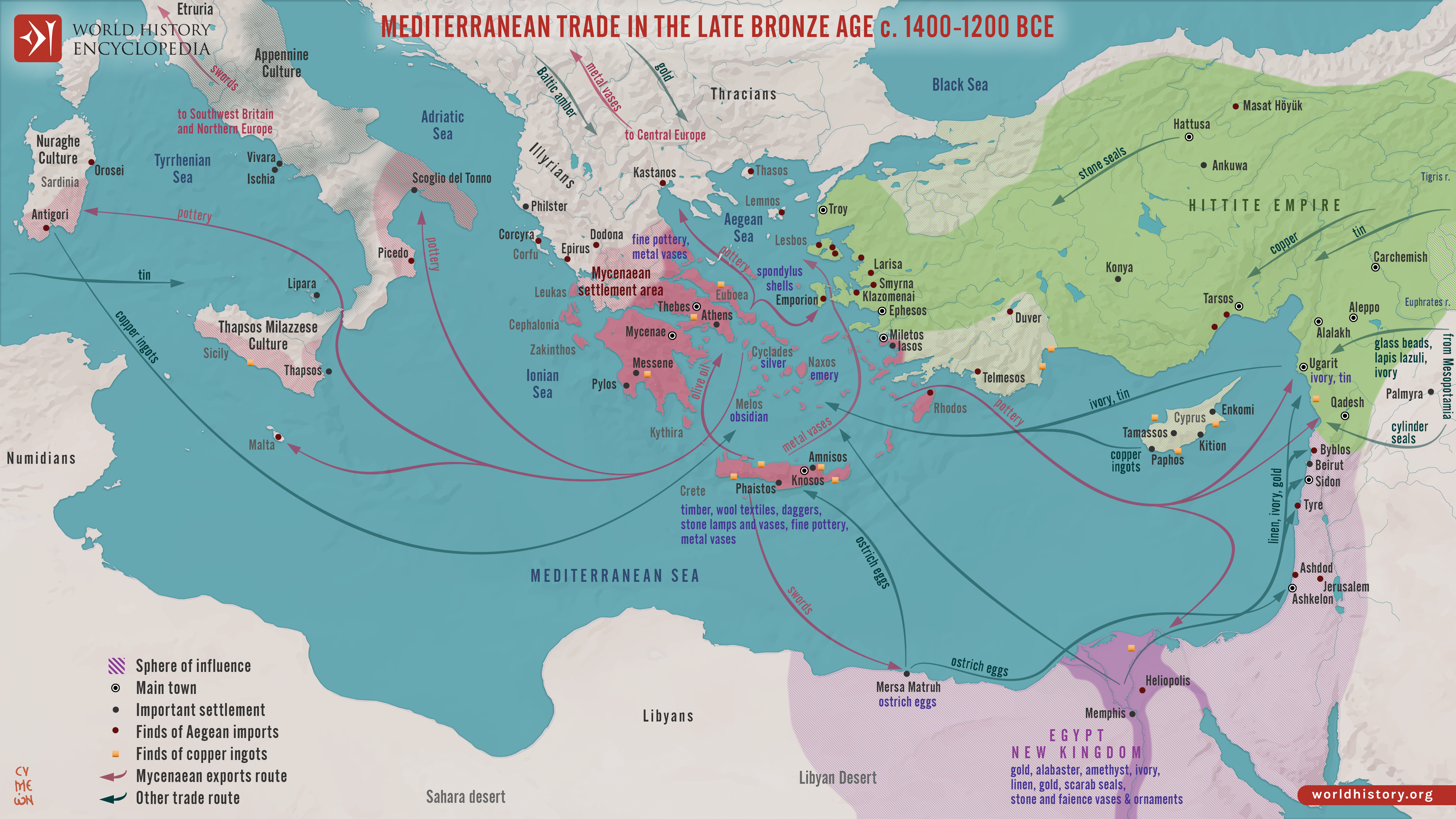
Between c. 1400 and 1200 BCE, the eastern [Mediterranean](https://www.worldhistory.org/disambiguation/mediterranean/) and [Aegean](https://www.worldhistory.org/aegean/) formed a densely interconnected system of exchange linking the [Mycenaean](https://www.worldhistory.org/Mycenaean_Civilization/) [palace](https://www.worldhistory.org/disambiguation/palace/) states, [New Kingdom](https://www.worldhistory.org/disambiguation/New_Kingdom/) [Egypt](https://www.worldhistory.org/egypt/), the [Hittite](https://www.worldhistory.org/hittite/) [Empire](https://www.worldhistory.org/empire/), [Cyprus](https://www.worldhistory.org/cyprus/), Levantine [city](https://www.worldhistory.org/city/)-states such as [Ugarit](https://www.worldhistory.org/ugarit/), and kingdoms farther east in [Mesopotamia](https://www.worldhistory.org/Mesopotamia/). Maritime and overland routes carried [copper](https://www.worldhistory.org/copper/) from Cyprus, tin needed for [bronze](https://www.worldhistory.org/disambiguation/bronze/) production, grain, timber, textiles, wine, olive oil, ceramics, ivory, glass, precious metals, and prestige goods. Commerce overlapped with diplomacy: documents such as the [Amarna Letters](https://www.worldhistory.org/Amarna_Letters/) reveal rulers exchanging gifts, arranging dynastic marriages, requesting valuable materials, and negotiating relationships within a wider international system.
These networks shaped political power and cultural change by moving people, technologies, artistic forms, religious ideas, and knowledge alongside commodities. Connections extended westward toward [Sicily](https://www.worldhistory.org/sicily/), Sardinia, and [Italy](https://www.worldhistory.org/italy/) and eastward through [Anatolia](https://www.worldhistory.org/Asia_Minor/) and the [Levant](https://www.worldhistory.org/levant/) into Mesopotamia. Such interdependence also created vulnerabilities. Around 1200 BCE, interacting pressures, including [warfare](https://www.worldhistory.org/warfare/), political instability, population movements, environmental stress, and disruptions to long-distance exchange, contributed to the destruction or abandonment of many [cities](https://www.worldhistory.org/city/) and the collapse of several palace-based political systems. The transformation was uneven rather than a single sudden collapse, but it profoundly reshaped Mediterranean societies and brought the Late [Bronze Age](https://www.worldhistory.org/disambiguation/Bronze_Age/) international system to an end.
#### Editorial Review
This human-authored image has been reviewed by our editorial team before publication to ensure accuracy, reliability and adherence to academic standards in accordance with our [editorial policy](https://www.worldhistory.org/static/editorial-policy/).
## About the Author
Simeon is a freelance visual designer and history educator, passionate about the human stories that shape the past.
- [Linkedin Profile](https://www.linkedin.com/in/simeon-netchev/)
## Cite This Work
### APA
Netchev, S. (2026, September 27). Map of the Late Bronze Age Mediterranean Trade Networks: Trade, Diplomacy & Interdependence, c. 1400–1200 BCE. *World History Encyclopedia*.
### Chicago
Netchev, Simeon. "Map of the Late Bronze Age Mediterranean Trade Networks: Trade, Diplomacy & Interdependence, c. 1400–1200 BCE." *World History Encyclopedia*, September 27, 2026. .
### MLA
Netchev, Simeon. "Map of the Late Bronze Age Mediterranean Trade Networks: Trade, Diplomacy & Interdependence, c. 1400–1200 BCE." *World History Encyclopedia*, 27 Sep 2026, .
## License & Copyright
Submitted by [Simeon Netchev](https://www.worldhistory.org/user/simeonnetchev/ "User Page: Simeon Netchev"), published on 27 September 2026. The copyright holder has published this content under the following license: [Creative Commons Attribution-NonCommercial-NoDerivs](https://creativecommons.org/licenses/by-nc/4.0deed.en). This licence only allows others to download this content and share it with others as long as the author is credited, but they can't change the content in any way or use it commercially. When republishing on the web a hyperlink back to the original content source URL must be included. Please note that content linked from this page may have different licensing terms.