---
title: Map of the Phoenician Trade and Colonization, c.1100-600 BCE: Trade, Colonies & Maritime Networks Across the Mediterranean
author: Simeon Netchev
source: https://www.worldhistory.org/image/14796/map-of-the-phoenician-trade-and-colonization-c1100/
format: machine-readable-alternate
license: Creative Commons Attribution-NonCommercial-NoDerivs (https://creativecommons.org/licenses/by-nc/4.0)
updated: 2026-07-10
---
# Map of the Phoenician Trade and Colonization, c.1100-600 BCE: Trade, Colonies & Maritime Networks Across the Mediterranean
_Authored by [Simeon Netchev](https://www.worldhistory.org/user/simeonnetchev/)_
## Image File
[](https://www.worldhistory.org/uploads/images/14796.png)
## Image Caption
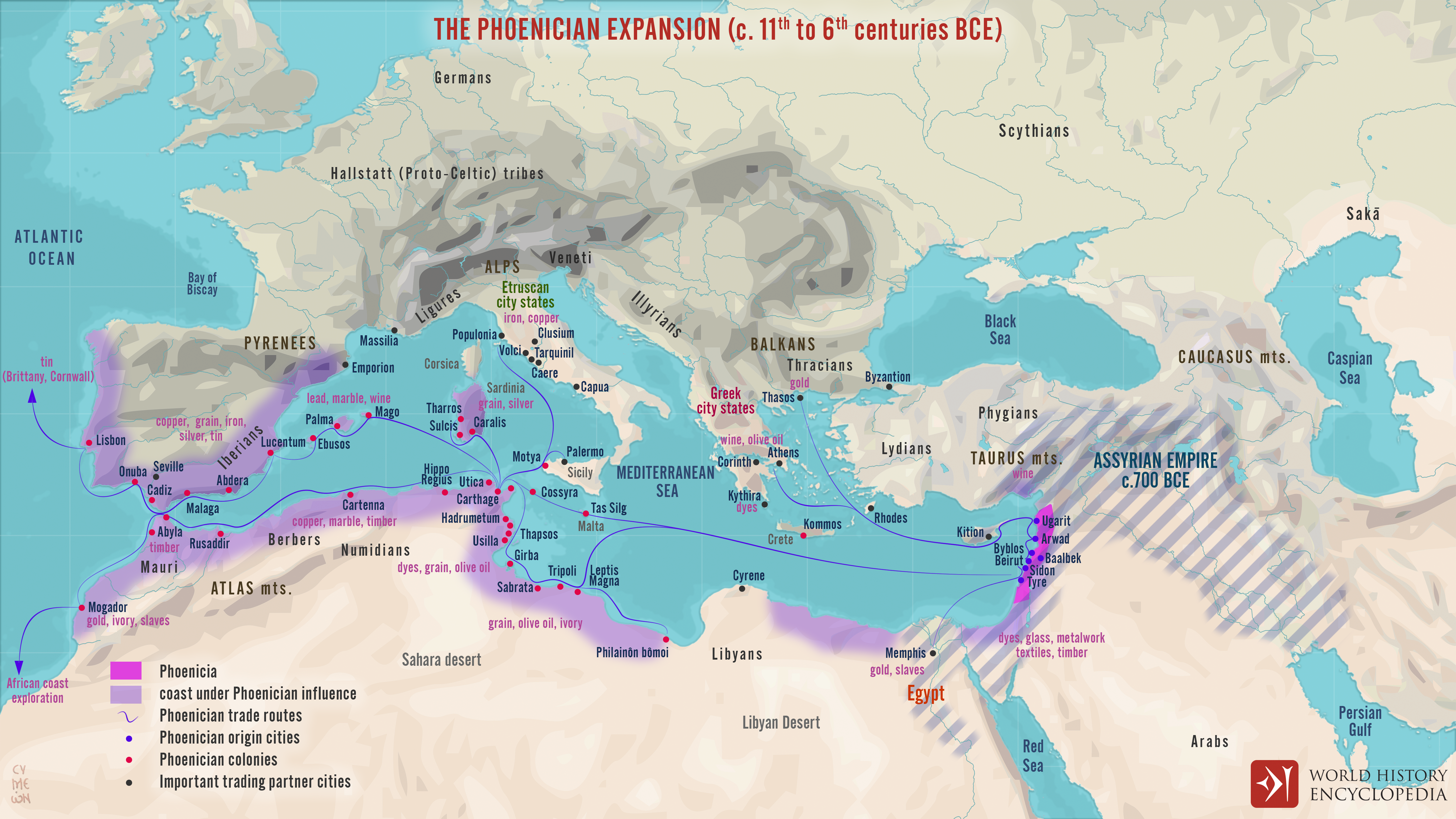
Between c. 1100 and 600 BCE, the Phoenician [city](https://www.worldhistory.org/city/)-states of the [Levant](https://www.worldhistory.org/levant/), especially [Tyre](https://www.worldhistory.org/Tyre/), [Sidon](https://www.worldhistory.org/sidon/), [Byblos](https://www.worldhistory.org/Byblos/), and Arwad, developed one of the ancient [Mediterranean](https://www.worldhistory.org/disambiguation/mediterranean/)’s most dynamic maritime trading systems. Rather than expanding through unified territorial [conquest](https://www.worldhistory.org/warfare/), they relied on seafaring, commercial diplomacy, coastal partnerships, and specialist production, linking the [Near East](https://www.worldhistory.org/Near_East/) with [Cyprus](https://www.worldhistory.org/cyprus/), [Egypt](https://www.worldhistory.org/egypt/), the [Aegean](https://www.worldhistory.org/aegean/), North [Africa](https://www.worldhistory.org/disambiguation/africa/), [Sicily](https://www.worldhistory.org/sicily/), Sardinia, [Iberia](https://www.worldhistory.org/disambiguation/iberia/), and Atlantic-facing routes. Their [trade](https://www.worldhistory.org/disambiguation/trade/) in cedar timber, purple dye, glass, textiles, metalwork, [silver](https://www.worldhistory.org/Silver/), [copper](https://www.worldhistory.org/copper/), grain, wine, and luxury goods connected several regional economies and helped spread Phoenician cultural influence far beyond the Levant.
From the 10th century BCE onward, this commercial reach increasingly developed into a pattern of settlement and [colonization](https://www.worldhistory.org/disambiguation/colonization/), as Phoenician and later [Punic](https://www.worldhistory.org/carthage/) communities established ports, colonies, and emporia across the central and western Mediterranean. [Carthage](https://www.worldhistory.org/carthage/), traditionally founded c. 814 BCE during the reign of Pygmalion of Tyre \[trad. reign c. 831–785 BCE\], became the most famous of these foundations and later emerged as a major power in its own right. By the 6th century BCE, pressure from larger imperial states, especially the [Neo-Assyrian Empire](https://www.worldhistory.org/Neo-Assyrian_Empire/) \[c. 911–609 BCE\] and the Neo-Babylonian [Empire](https://www.worldhistory.org/empire/) under [Nebuchadnezzar II](https://www.worldhistory.org/Nebuchadnezzar_II/) \[reign 605–562 BCE\], gradually reduced Phoenician independence in the Levant. Yet Phoenician language, [religion](https://www.worldhistory.org/religion/), craftsmanship, and commercial practices continued across the wider Phoenician-Punic world long after the homeland came under imperial domination.
#### Editorial Review
This human-authored image has been reviewed by our editorial team before publication to ensure accuracy, reliability and adherence to academic standards in accordance with our [editorial policy](https://www.worldhistory.org/static/editorial-policy/).
## About the Author
Simeon is a freelance visual designer and history educator, passionate about the human stories that shape the past.
- [Linkedin Profile](https://www.linkedin.com/in/simeon-netchev/)
## Cite This Work
### APA
Netchev, S. (2026, July 10). Map of the Phoenician Trade and Colonization, c.1100-600 BCE: Trade, Colonies & Maritime Networks Across the Mediterranean. *World History Encyclopedia*.
### Chicago
Netchev, Simeon. "Map of the Phoenician Trade and Colonization, c.1100-600 BCE: Trade, Colonies & Maritime Networks Across the Mediterranean." *World History Encyclopedia*, July 10, 2026. .
### MLA
Netchev, Simeon. "Map of the Phoenician Trade and Colonization, c.1100-600 BCE: Trade, Colonies & Maritime Networks Across the Mediterranean." *World History Encyclopedia*, 10 Jul 2026, .
## License & Copyright
Submitted by [Simeon Netchev](https://www.worldhistory.org/user/simeonnetchev/ "User Page: Simeon Netchev"), published on 10 July 2026. The copyright holder has published this content under the following license: [Creative Commons Attribution-NonCommercial-NoDerivs](https://creativecommons.org/licenses/by-nc/4.0deed.en). This licence only allows others to download this content and share it with others as long as the author is credited, but they can't change the content in any way or use it commercially. When republishing on the web a hyperlink back to the original content source URL must be included. Please note that content linked from this page may have different licensing terms.