---
title: Map of the World According to Christopher Columbus c. 1490
author: Simeon Netchev
source: https://www.worldhistory.org/image/14664/map-of-the-world-according-to-christopher-columbus/
format: machine-readable-alternate
license: Creative Commons Attribution-NonCommercial-NoDerivs (https://creativecommons.org/licenses/by-nc/4.0)
updated: 2026-02-21
---
# Map of the World According to Christopher Columbus c. 1490
_Authored by [Simeon Netchev](https://www.worldhistory.org/user/simeonnetchev/)_
## Image File
[](https://www.worldhistory.org/uploads/images/14664.png)
## Image Caption
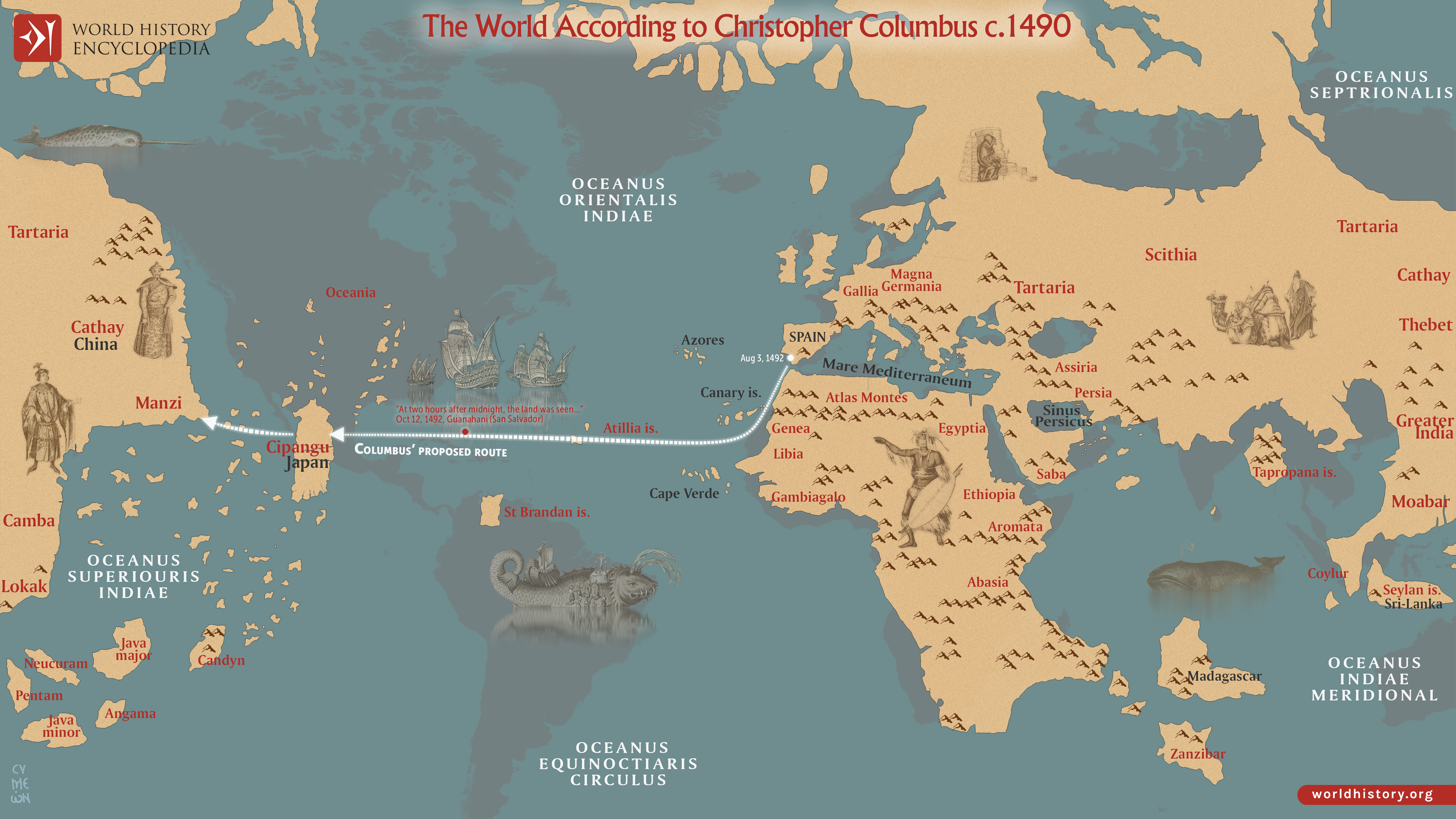
This map reflects [Christopher Columbus](https://www.worldhistory.org/Christopher_Columbus/)’s (c. 1451-1506) geographical assumptions prior to his first Atlantic voyage in 1492, undertaken during the reign of the Catholic Monarchs Ferdinand II of Aragon (reign 1479-1516) and [Isabella I of Castile](https://www.worldhistory.org/Isabella_I_of_Castile/) (reign 1474-1504). [Columbus](https://www.worldhistory.org/Christopher_Columbus/) relied heavily on the cosmographical ideas of the Florentine scholar Paolo dal Pozzo Toscanelli (letter of 1474), whose projection underestimated the circumference of the Earth and exaggerated the eastward extension of Asia. Although ancient scholars such as [Eratosthenes](https://www.worldhistory.org/Eratosthenes/) (3rd century BCE) had calculated the Earth’s circumference with remarkable accuracy, Columbus adopted smaller estimates derived from later sources and conflated different units of measurement, producing a significantly reduced westward distance between [Europe](https://www.worldhistory.org/europe/) and Asia.
By Columbus’s calculation, Cipangu ([Japan](https://www.worldhistory.org/disambiguation/Japan/)) lay roughly 2,500 nautical miles (c. 4,000 km) west of the Canary Islands, within what he believed to be feasible sailing range for late 15th-century caravels. In reality, the distance to East Asia exceeded 10,000 nautical miles (c. 19,000 km). His voyage succeeded not because his calculations were correct, but because the American continents lay unexpectedly between Europe and Asia.
#### Editorial Review
This human-authored image has been reviewed by our editorial team before publication to ensure accuracy, reliability and adherence to academic standards in accordance with our [editorial policy](https://www.worldhistory.org/static/editorial-policy/).
## About the Author
Simeon is a freelance visual designer and history educator, passionate about the human stories that shape the past.
- [Linkedin Profile](https://www.linkedin.com/in/simeon-netchev/)
## Cite This Work
### APA
Netchev, S. (2021, October 01). Map of the World According to Christopher Columbus c. 1490. *World History Encyclopedia*.
### Chicago
Netchev, Simeon. "Map of the World According to Christopher Columbus c. 1490." *World History Encyclopedia*, October 01, 2021. .
### MLA
Netchev, Simeon. "Map of the World According to Christopher Columbus c. 1490." *World History Encyclopedia*, 01 Oct 2021, .
## License & Copyright
Submitted by [Simeon Netchev](https://www.worldhistory.org/user/simeonnetchev/ "User Page: Simeon Netchev"), published on 01 October 2021. The copyright holder has published this content under the following license: [Creative Commons Attribution-NonCommercial-NoDerivs](https://creativecommons.org/licenses/by-nc/4.0deed.en). This licence only allows others to download this content and share it with others as long as the author is credited, but they can't change the content in any way or use it commercially. When republishing on the web a hyperlink back to the original content source URL must be included. Please note that content linked from this page may have different licensing terms.