---
title: Map of the Silk Road During the Late 8th Century
author: Simeon Netchev
source: https://www.worldhistory.org/image/146/map-of-the-silk-road-during-the-late-8th-century/
format: machine-readable-alternate
license: Creative Commons Attribution-NonCommercial-NoDerivs (https://creativecommons.org/licenses/by-nc/4.0)
updated: 2026-02-13
---
# Map of the Silk Road During the Late 8th Century
_Authored by [Simeon Netchev](https://www.worldhistory.org/user/simeonnetchev/)_
## Image File
[](https://www.worldhistory.org/uploads/images/146.png)
## Image Caption
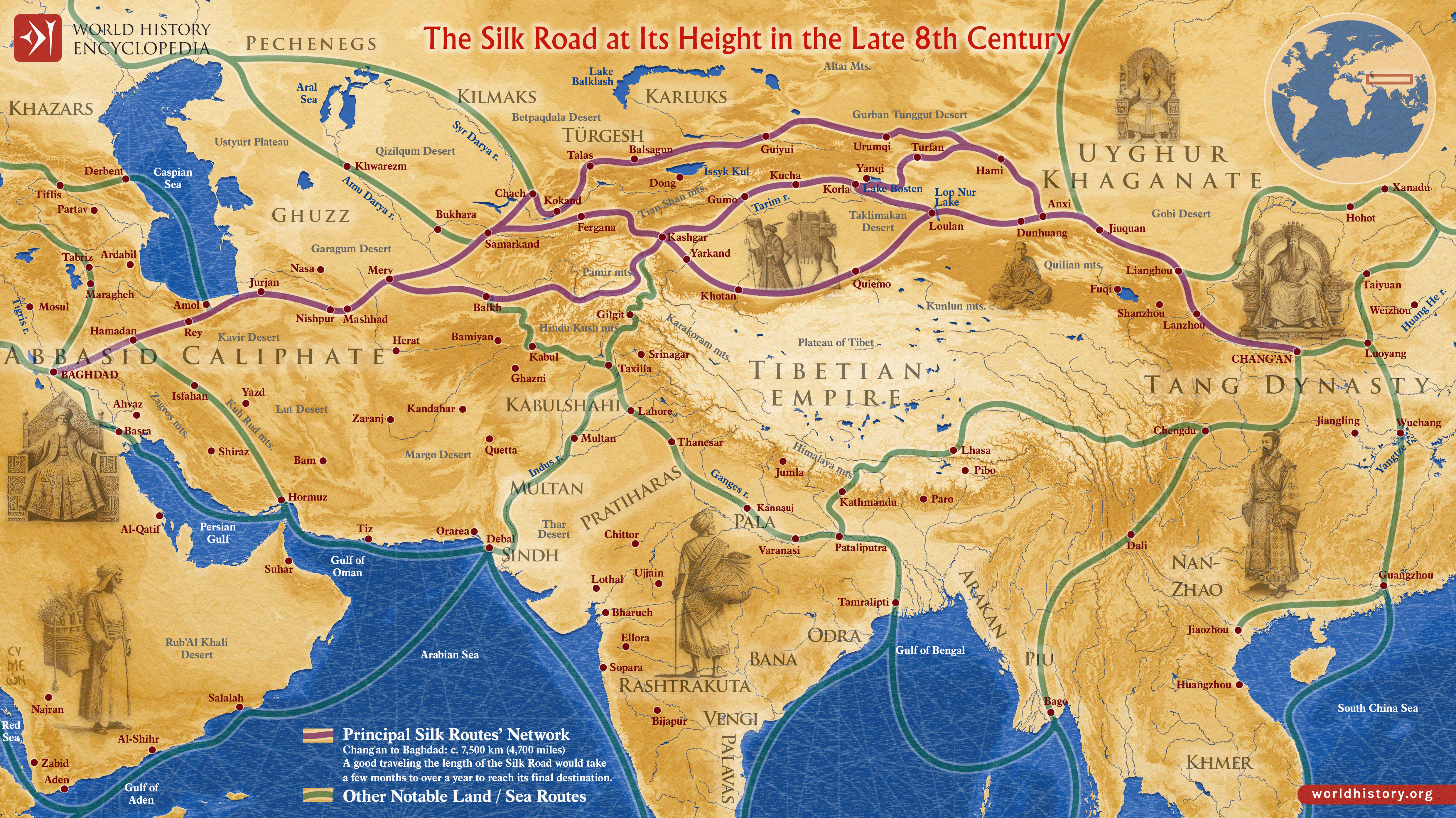
In the late 8th century CE, the interconnected caravan routes later termed the “Silk Road” formed a transcontinental system linking East Asia, Central Asia, the Islamic world, and parts of [Europe](https://www.worldhistory.org/europe/). The label “Silk Road” (German: Seidenstraße) was coined much later, in 1877, by the German geographer Ferdinand von Richthofen to describe these long-distance [trade](https://www.worldhistory.org/disambiguation/trade/) corridors, though contemporaries understood them as overlapping commercial and diplomatic routes rather than a single road. By this period, the [Tang Dynasty](https://www.worldhistory.org/Tang_Dynasty/) (618–907 CE), particularly under Emperor [Xuanzong](https://www.worldhistory.org/disambiguation/Xuanzong/) (reign 712–756 CE), had projected Chinese influence deep into Central Asia, while frontier conflicts, such as the [Battle](https://www.worldhistory.org/disambiguation/battle/) of Talas (751 CE), revealed the competitive nature of Eurasian geopolitics.
To the west, the [Abbasid Caliphate](https://www.worldhistory.org/Abbasid_Dynasty/) (750–1258 CE), founded in 750 CE and ruling from Baghdad from 762 CE onward, integrated transcontinental trade into a rapidly expanding Islamic economic sphere. The Uyghur Khaganate (744–840 CE) secured key steppe corridors, facilitating exchange between sedentary empires and nomadic polities. Major urban centers, Samarkand, Bukhara, Kashgar, Merv, and Nishapur, flourished as hubs of commerce, scholarship, and religious transmission, enabling the circulation not only of [silk](https://www.worldhistory.org/Silk/) and [silver](https://www.worldhistory.org/Silver/) but also of papermaking, artistic styles, and religious traditions such as [Buddhism](https://www.worldhistory.org/buddhism/) and [Islam](https://www.worldhistory.org/islam/). By the 9th century CE, however, political fragmentation in Central Asia and the growing importance of Indian Ocean maritime routes gradually reduced the relative prominence of overland exchange.
#### Editorial Review
This human-authored image has been reviewed by our editorial team before publication to ensure accuracy, reliability and adherence to academic standards in accordance with our [editorial policy](https://www.worldhistory.org/static/editorial-policy/).
## About the Author
Simeon is a freelance visual designer and history educator, passionate about the human stories that shape the past.
- [Linkedin Profile](https://www.linkedin.com/in/simeon-netchev/)
## Cite This Work
### APA
Netchev, S. (2025, February 04). Map of the Silk Road During the Late 8th Century. *World History Encyclopedia*.
### Chicago
Netchev, Simeon. "Map of the Silk Road During the Late 8th Century." *World History Encyclopedia*, February 04, 2025. .
### MLA
Netchev, Simeon. "Map of the Silk Road During the Late 8th Century." *World History Encyclopedia*, 04 Feb 2025, .
## License & Copyright
Submitted by [Simeon Netchev](https://www.worldhistory.org/user/simeonnetchev/ "User Page: Simeon Netchev"), published on 04 February 2025. The copyright holder has published this content under the following license: [Creative Commons Attribution-NonCommercial-NoDerivs](https://creativecommons.org/licenses/by-nc/4.0deed.en). This licence only allows others to download this content and share it with others as long as the author is credited, but they can't change the content in any way or use it commercially. When republishing on the web a hyperlink back to the original content source URL must be included. Please note that content linked from this page may have different licensing terms.