---
title: Map of the Trade Networks of the Ancient Mediterranean World: Connectivity & Expansion in the Archaic and Classical Ages
author: Simeon Netchev
source: https://www.worldhistory.org/image/14421/map-of-the-trade-networks-of-the-ancient-mediterra/
format: machine-readable-alternate
license: Creative Commons Attribution-NonCommercial-NoDerivs (https://creativecommons.org/licenses/by-nc/4.0)
updated: 2026-05-03
---
# Map of the Trade Networks of the Ancient Mediterranean World: Connectivity & Expansion in the Archaic and Classical Ages
_Authored by [Simeon Netchev](https://www.worldhistory.org/user/simeonnetchev/)_
## Image File
[](https://www.worldhistory.org/uploads/images/14421.png)
## Image Caption
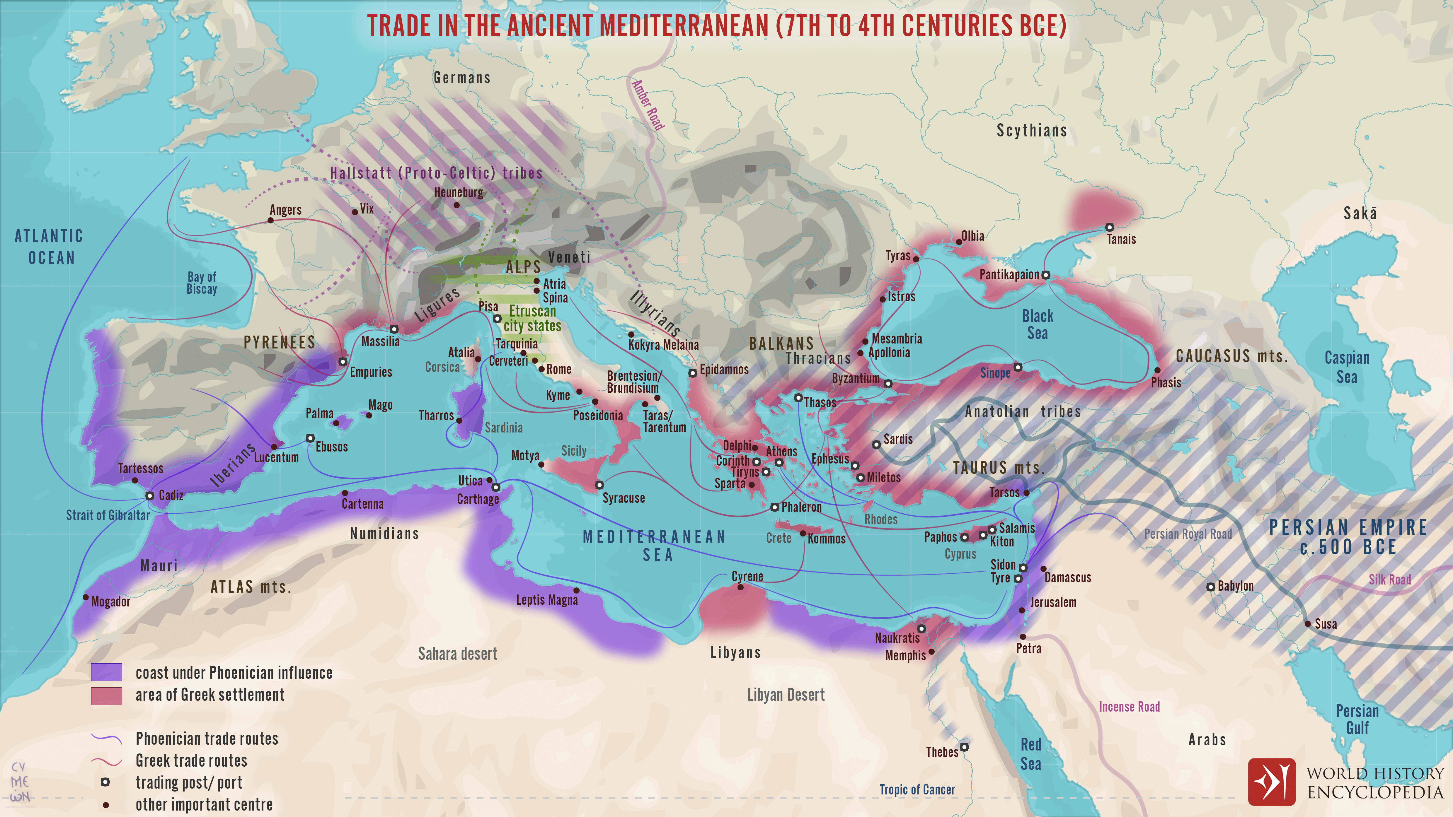
Between the 7th and 4th centuries BCE, the [Mediterranean](https://www.worldhistory.org/disambiguation/mediterranean/) functioned as a highly interconnected zone of maritime exchange, shaped by the expanding networks of Phoenician and [Hellenic](https://www.worldhistory.org/greece/) communities. Originating from the [Levant](https://www.worldhistory.org/levant/), Phoenician traders established a chain of coastal settlements and commercial outposts across the western and southern Mediterranean, while [Greek](https://www.worldhistory.org/disambiguation/greek/)-speaking settlers founded [poleis](https://www.worldhistory.org/Polis/) from [Asia Minor](https://www.worldhistory.org/Asia_Minor/) to southern [Italy](https://www.worldhistory.org/italy/), [Sicily](https://www.worldhistory.org/sicily/), and the Black Sea. These movements were not centralized imperial projects but flexible systems of [trade](https://www.worldhistory.org/disambiguation/trade/), migration, and cultural interaction. Together, they created overlapping spheres of influence that linked distant regions, from [Iberia](https://www.worldhistory.org/disambiguation/iberia/) to the eastern Mediterranean, into a shared economic and cultural space during the [Archaic](https://www.worldhistory.org/disambiguation/Archaic/) and early Classical periods.
These networks facilitated the circulation of key commodities, including metals from Iberia, timber, wine, olive oil, and luxury goods, while also transmitting ideas, artistic forms, and technologies such as alphabetic [writing](https://www.worldhistory.org/writing/). Phoenician foundations like [Carthage](https://www.worldhistory.org/carthage/) and Hellenic colonies across the central and eastern Mediterranean became hubs within broader exchange systems, interacting with major powers such as the [Achaemenid](https://www.worldhistory.org/disambiguation/Achaemenid/) [Persian Empire](https://www.worldhistory.org/disambiguation/Persian_Empire/) (c. 550–330 BCE). At the same time, maritime routes connected with overland corridors extending into Southwest Asia and beyond, reinforcing the Mediterranean’s role as a central axis of early interregional trade.
#### Editorial Review
This human-authored image has been reviewed by our editorial team before publication to ensure accuracy, reliability and adherence to academic standards in accordance with our [editorial policy](https://www.worldhistory.org/static/editorial-policy/).
## About the Author
Simeon is a freelance visual designer and history educator, passionate about the human stories that shape the past.
- [Linkedin Profile](https://www.linkedin.com/in/simeon-netchev/)
## Cite This Work
### APA
Netchev, S. (2026, May 03). Map of the Trade Networks of the Ancient Mediterranean World: Connectivity & Expansion in the Archaic and Classical Ages. *World History Encyclopedia*.
### Chicago
Netchev, Simeon. "Map of the Trade Networks of the Ancient Mediterranean World: Connectivity & Expansion in the Archaic and Classical Ages." *World History Encyclopedia*, May 03, 2026. .
### MLA
Netchev, Simeon. "Map of the Trade Networks of the Ancient Mediterranean World: Connectivity & Expansion in the Archaic and Classical Ages." *World History Encyclopedia*, 03 May 2026, .
## License & Copyright
Submitted by [Simeon Netchev](https://www.worldhistory.org/user/simeonnetchev/ "User Page: Simeon Netchev"), published on 03 May 2026. The copyright holder has published this content under the following license: [Creative Commons Attribution-NonCommercial-NoDerivs](https://creativecommons.org/licenses/by-nc/4.0deed.en). This licence only allows others to download this content and share it with others as long as the author is credited, but they can't change the content in any way or use it commercially. When republishing on the web a hyperlink back to the original content source URL must be included. Please note that content linked from this page may have different licensing terms.