---
title: Map of the Portuguese Commercial Empire, c. 1580: Fortified Ports, Maritime Trade Routes, and Global Sea Power
author: Simeon Netchev
source: https://www.worldhistory.org/image/14123/map-of-the-portuguese-commercial-empire-c-1580/
format: machine-readable-alternate
license: Creative Commons Attribution-NonCommercial-NoDerivs (https://creativecommons.org/licenses/by-nc/4.0)
updated: 2026-05-10
---
# Map of the Portuguese Commercial Empire, c. 1580: Fortified Ports, Maritime Trade Routes, and Global Sea Power
_Authored by [Simeon Netchev](https://www.worldhistory.org/user/simeonnetchev/)_
## Image File
[](https://www.worldhistory.org/uploads/images/14123.png)
## Image Caption
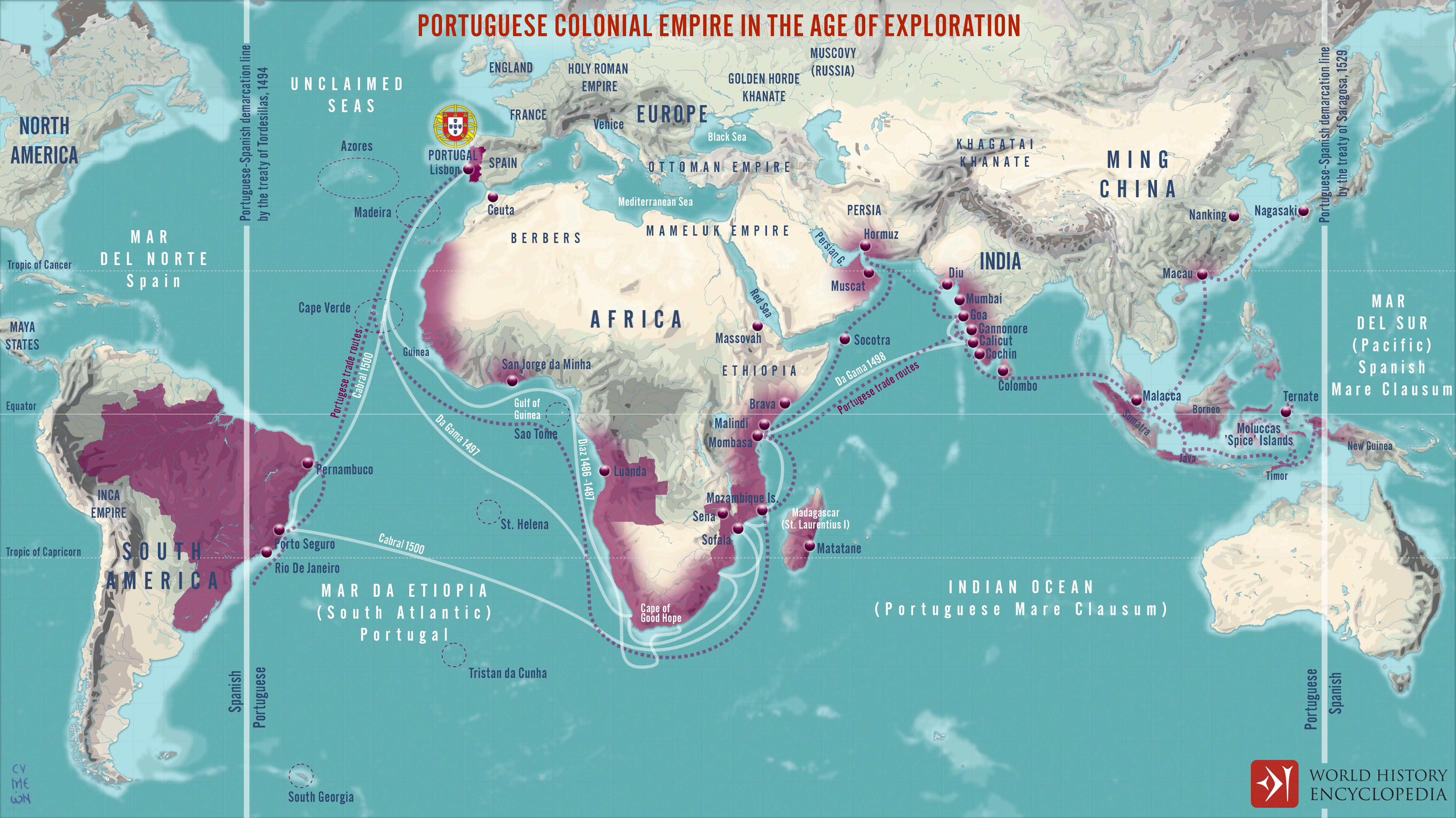
Portugal established the first and longest-lasting of [Europe](https://www.worldhistory.org/europe/)’s overseas empires, developing a maritime-commercial network that connected the Atlantic, Indian, and Pacific Oceans from the 15th century onward. Under rulers such as João I (reign 1385-1433), Henry the Navigator (1394–1460), João II (reign 1481-1495), and Manuel I (reign 1495-1521), Portuguese expansion was driven by the pursuit of direct access to the spice markets of Asia, control of strategic maritime chokepoints, and competition with Islamic and Venetian [trade](https://www.worldhistory.org/disambiguation/trade/) networks. Rather than creating a continuous territorial [empire](https://www.worldhistory.org/empire/), Portugal established a system of fortified ports, naval patrols, treaty alliances, and commercial monopolies stretching from West [Africa](https://www.worldhistory.org/disambiguation/africa/) and Brazil to [India](https://www.worldhistory.org/india/), Southeast Asia, [China](https://www.worldhistory.org/china/), and [Japan](https://www.worldhistory.org/disambiguation/Japan/).
The [conquest](https://www.worldhistory.org/warfare/) of Ceuta in 1415 marked the symbolic beginning of Portuguese overseas expansion, extending the spirit of the [Reconquista](https://www.worldhistory.org/Reconquista/) into North Africa. During the 15th century, Portuguese navigators gradually explored the Atlantic islands and West African coast, aided by advances in cartography, shipbuilding, and navigation. Bartolomeu Dias rounded the Cape of Good Hope in 1488, and [Vasco da Gama](https://www.worldhistory.org/Vasco_da_Gama/) reached India in 1498, opening a direct maritime route between Europe and the Indian Ocean trade world. By c. 1580, Portugal had established major commercial and strategic centers at Goa, Hormuz, Malacca, Macau, Mozambique, and along the Atlantic coast of Brazil. The year 1580 also marked a major turning point: after the [death](https://www.worldhistory.org/disambiguation/Death/) of Sebastian I of Portugal (reign 1557–1578) in Morocco and the resulting succession crisis, [Philip II](https://www.worldhistory.org/disambiguation/Philip_II/) of Spain (reign 1556–1598) became Philip I of Portugal (reign 1581–1598), creating the Iberian Union (1580–1640).
#### Editorial Review
This human-authored image has been reviewed by our editorial team before publication to ensure accuracy, reliability and adherence to academic standards in accordance with our [editorial policy](https://www.worldhistory.org/static/editorial-policy/).
## About the Author
Simeon is a freelance visual designer and history educator, passionate about the human stories that shape the past.
- [Linkedin Profile](https://www.linkedin.com/in/simeon-netchev/)
## Cite This Work
### APA
Netchev, S. (2026, May 10). Map of the Portuguese Commercial Empire, c. 1580: Fortified Ports, Maritime Trade Routes, and Global Sea Power. *World History Encyclopedia*.
### Chicago
Netchev, Simeon. "Map of the Portuguese Commercial Empire, c. 1580: Fortified Ports, Maritime Trade Routes, and Global Sea Power." *World History Encyclopedia*, May 10, 2026. .
### MLA
Netchev, Simeon. "Map of the Portuguese Commercial Empire, c. 1580: Fortified Ports, Maritime Trade Routes, and Global Sea Power." *World History Encyclopedia*, 10 May 2026, .
## License & Copyright
Submitted by [Simeon Netchev](https://www.worldhistory.org/user/simeonnetchev/ "User Page: Simeon Netchev"), published on 10 May 2026. The copyright holder has published this content under the following license: [Creative Commons Attribution-NonCommercial-NoDerivs](https://creativecommons.org/licenses/by-nc/4.0deed.en). This licence only allows others to download this content and share it with others as long as the author is credited, but they can't change the content in any way or use it commercially. When republishing on the web a hyperlink back to the original content source URL must be included. Please note that content linked from this page may have different licensing terms.