---
title: Map of Viking Exploration, 8th-11th Century
author: Simeon Netchev
source: https://www.worldhistory.org/image/14067/map-of-viking-exploration-8th-11th-century/
format: machine-readable-alternate
license: Creative Commons Attribution-NonCommercial-NoDerivs (https://creativecommons.org/licenses/by-nc/4.0)
updated: 2025-05-26
---
# Map of Viking Exploration, 8th-11th Century
_Authored by [Simeon Netchev](https://www.worldhistory.org/user/simeonnetchev/)_
## Image File
[](https://www.worldhistory.org/uploads/images/14067.png)
## Image Caption
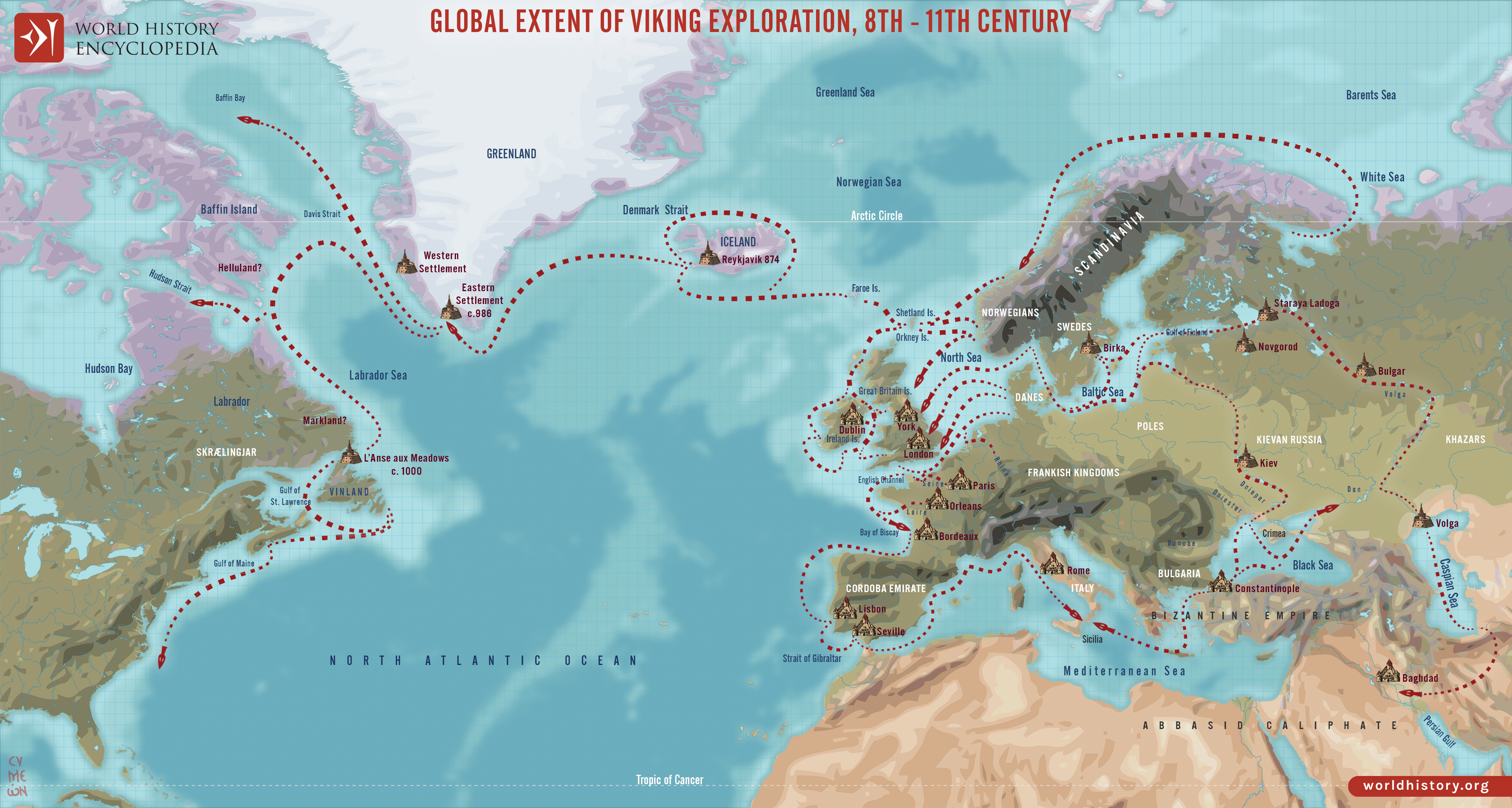
This map illustrates the sweep of [Viking](https://www.worldhistory.org/Vikings/) exploration between the late 8th and early 11th centuries, charting longship routes from Scandinavia to the British Isles, Normandy, [Iberia](https://www.worldhistory.org/disambiguation/iberia/), Russia, the [Mediterranean](https://www.worldhistory.org/disambiguation/mediterranean/), and across the North Atlantic to Iceland, Greenland, and Newfoundland. It highlights how mobility, [trade](https://www.worldhistory.org/disambiguation/trade/), and raiding knit these far-flung coasts together.
Beyond familiar raids in [Britain](https://www.worldhistory.org/disambiguation/Britain/) and [Ireland](https://www.worldhistory.org/disambiguation/Ireland/), Norse crews founded Dublin, settled Normandy, and navigated Russian rivers to [Byzantium](https://www.worldhistory.org/Byzantium/) and the Caspian Sea, where they served as Varangian mercenaries. Westward, they created farming colonies in Iceland and Greenland and attempted a short-lived outpost at [Vinland](https://www.worldhistory.org/Vinland/) (L’Anse aux Meadows, Canada). These journeys left lasting genetic, linguistic, and political footprints—from Normandy’s ducal line to the [Varangian Guard](https://www.worldhistory.org/Varangian_Guard/) of [Constantinople](https://www.worldhistory.org/Constantinople/)—reshaping medieval [Europe](https://www.worldhistory.org/europe/) and the North Atlantic world.
#### Editorial Review
This human-authored image has been reviewed by our editorial team before publication to ensure accuracy, reliability and adherence to academic standards in accordance with our [editorial policy](https://www.worldhistory.org/static/editorial-policy/).
## About the Author
Simeon is a freelance visual designer and history educator, passionate about the human stories that shape the past.
- [Linkedin Profile](https://www.linkedin.com/in/simeon-netchev/)
## Cite This Work
### APA
Netchev, S. (2021, May 25). Map of Viking Exploration, 8th-11th Century. *World History Encyclopedia*.
### Chicago
Netchev, Simeon. "Map of Viking Exploration, 8th-11th Century." *World History Encyclopedia*, May 25, 2021. .
### MLA
Netchev, Simeon. "Map of Viking Exploration, 8th-11th Century." *World History Encyclopedia*, 25 May 2021, .
## License & Copyright
Submitted by [Simeon Netchev](https://www.worldhistory.org/user/simeonnetchev/ "User Page: Simeon Netchev"), published on 25 May 2021. The copyright holder has published this content under the following license: [Creative Commons Attribution-NonCommercial-NoDerivs](https://creativecommons.org/licenses/by-nc/4.0deed.en). This licence only allows others to download this content and share it with others as long as the author is credited, but they can't change the content in any way or use it commercially. When republishing on the web a hyperlink back to the original content source URL must be included. Please note that content linked from this page may have different licensing terms.