---
title: Map of the Frankish Kingdoms AD 481-511
author: Peter Kessler
source: https://www.worldhistory.org/image/1386/map-of-the-frankish-kingdoms-ad-481-511/
format: machine-readable-alternate
updated: 1970-01-01
---
# Map of the Frankish Kingdoms AD 481-511
_Authored by Peter Kessler_
## Image File
[](https://www.worldhistory.org/uploads/images/1386.jpg)
## Image Caption
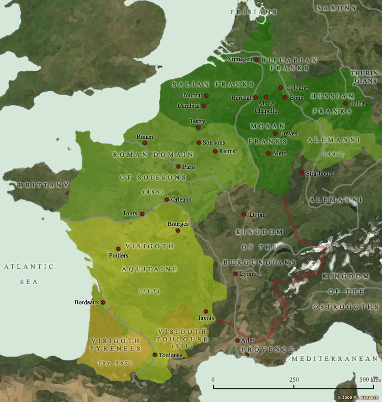
With the accession of Clovis, son of [Childeric I](https://www.worldhistory.org/Childeric_I/) of the Salian [Franks](https://www.worldhistory.org/Franks/), the Germanic occupiers of north-eastern [Gaul](https://www.worldhistory.org/gaul/) had found a king who would change their fortunes out of all recognition. Rather than follow his father's policy of allying himself with the [Roman](https://www.worldhistory.org/disambiguation/Roman/) domain of Soissons and trying to preserve some kind of peace in Gaul, Clovis pursued a highly aggressive policy of expansion. He united the two main branches of the Franks, the Salians on the west bank of the Rhine and the Ripuarians on the east bank, and converted them all to [Christianity](https://www.worldhistory.org/christianity/) in AD 497. Between then and 509 he also took steps to eliminate his rival Frankish kings, killing them and annexing their territory. In 486 he conquered the Roman domain of Soissons, opening up western and central Gaul and allowing him to move the Frankish capital to the small town of [Paris](https://www.worldhistory.org/disambiguation/paris/). The [Alemanni](https://www.worldhistory.org/alemanni/) were narrowly conquered in 496. In 507 the [Visigoth](https://www.worldhistory.org/visigoth/) kingdom of Toulouse, which encompassed all of southern and central Gaul, was defeated and the [Visigoths](https://www.worldhistory.org/visigoth/) forced to retreat into Spain. The Auvergne was secured, but although Clovis also claimed Aquitaine, the region remained disputed for quite some time afterwards. A rare defeat came in 510, when an [Ostrogoth](https://www.worldhistory.org/ostrogoth/) success at Narbonne forced Clovis away from the [Mediterranean](https://www.worldhistory.org/disambiguation/mediterranean/) coast. The Franks quickly became the dominant Germanic tribal grouping in Gaul under Clovis, laying the foundations for further expansion south and eastwards under subsequent Merovingian and Carolingian kings.
## Cite This Work
### APA
Kessler, P. (2013, August 14). Map of the Frankish Kingdoms AD 481-511. *World History Encyclopedia*.
### Chicago
Kessler, Peter. "Map of the Frankish Kingdoms AD 481-511." *World History Encyclopedia*, August 14, 2013. .
### MLA
Kessler, Peter. "Map of the Frankish Kingdoms AD 481-511." *World History Encyclopedia*, 14 Aug 2013, .
## License & Copyright
© P L Kessler / [The History Files](http://www.historyfiles.co.uk/). Republished with the author's permission. [Original image](http://www.historyfiles.co.uk/FeaturesEurope/FranceMapAD481.htm) by [**Peter Kessler**](http://www.historyfiles.co.uk/FeaturesEurope/FranceMapAD481.htm). Submitted by [Jan van der Crabben](https://www.worldhistory.org/user/jvdc/ "User Page: Jan van der Crabben"), published on 14 August 2013. The copyright holder has published this content under the following license: [Copyright](http://en.wikipedia.org/wiki/Copyright). You cannot use, copy, distribute, or modify this item without explicit permission from the author. Please note that content linked from this page may have different licensing terms.