---
title: Map of Sumer
author: P L Kessler
source: https://www.worldhistory.org/image/1352/map-of-sumer/
format: machine-readable-alternate
updated: 1970-01-01
---
# Map of Sumer
_Authored by P L Kessler_
## Image File
[](https://www.worldhistory.org/uploads/images/1352.jpg)
## Image Caption
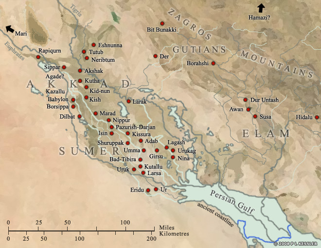
The area which formed [Sumer](https://www.worldhistory.org/sumer/) started at the Persian Gulf and reached north to the 'neck' of [Mesopotamia](https://www.worldhistory.org/Mesopotamia/) where the two rivers, the Tigris and the Euphrates meander much closer to each other. To the east loomed the Zagros Mountains, where scattered [city](https://www.worldhistory.org/city/) states thrived on [trade](https://www.worldhistory.org/disambiguation/trade/) and learning from Sumer, and to the west was the vast expanse of the Arabian desert. The rivers have changed course considerably in the last four thousand years, moving well away from some of the [cities](https://www.worldhistory.org/city/) and causing the complex network of canals to dry up, but at the time, the two rivers had separate entrances into the foreshortened Gulf. Some of the earliest cities, such as Sippar, Borsippa and Kish in the north, and [Ur](https://www.worldhistory.org/ur/), [Uruk](https://www.worldhistory.org/uruk/) and [Eridu](https://www.worldhistory.org/eridu/) in the south formed the endpoints of what became that complex network of cities and canals. Girsu and [Nippur](https://www.worldhistory.org/disambiguation/nippur/) were highly important religious centres, but other cities, such as Larsa, Eshnunna, [Babylon](https://www.worldhistory.org/babylon/) and Isin didn't really emerge as such until after the end of [Sumerian](https://www.worldhistory.org/Sumerians/) [civilisation](https://www.worldhistory.org/civilization/) in circa 2000 BC.
## Cite This Work
### APA
Kessler, P. L. (2013, July 11). Map of Sumer. *World History Encyclopedia*.
### Chicago
Kessler, P L. "Map of Sumer." *World History Encyclopedia*, July 11, 2013. .
### MLA
Kessler, P L. "Map of Sumer." *World History Encyclopedia*, 11 Jul 2013, .
## License & Copyright
© P L Kessler / [The History Files](http://www.historyfiles.co.uk/). Republished with the author's permission. [Original image](http://www.historyfiles.co.uk/FeaturesMiddEast/MesopotamiaSumerMap.htm) by [**P L Kessler**](http://www.historyfiles.co.uk/FeaturesMiddEast/MesopotamiaSumerMap.htm). Submitted by [Jan van der Crabben](https://www.worldhistory.org/user/jvdc/ "User Page: Jan van der Crabben"), published on 11 July 2013. The copyright holder has published this content under the following license: [Copyright](http://en.wikipedia.org/wiki/Copyright). You cannot use, copy, distribute, or modify this item without explicit permission from the author. Please note that content linked from this page may have different licensing terms.