---
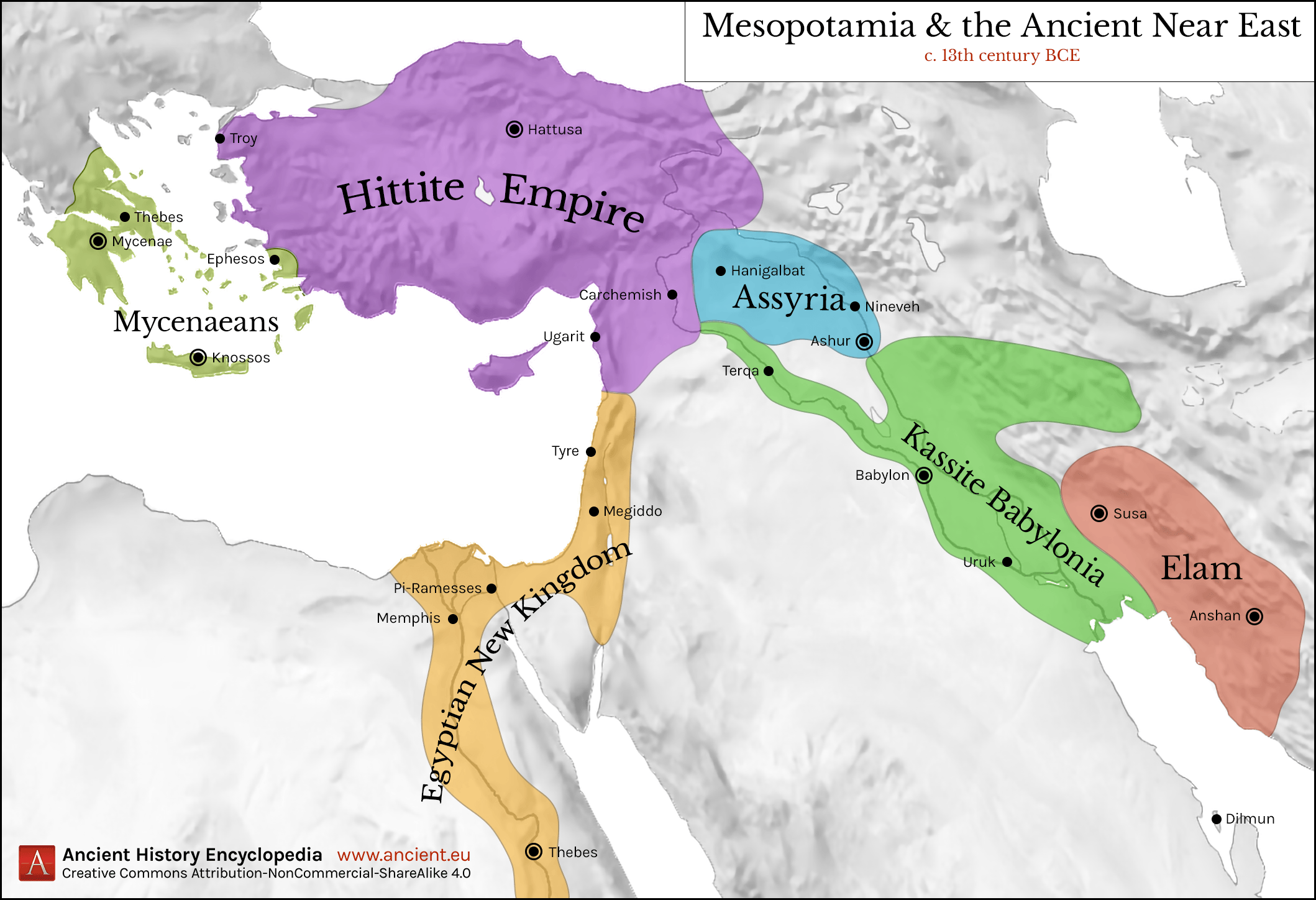
title: Map of Mesopotamia and the Ancient Near East, c. 1300 BCE
author: Jan van der Crabben
source: https://www.worldhistory.org/image/11823/map-of-mesopotamia-and-the-ancient-near-east-c-130/
format: machine-readable-alternate
license: Creative Commons Attribution-NonCommercial-ShareAlike (https://creativecommons.org/licenses/by-nc-sa/4.0/)
updated: 1970-01-01
---
# Map of Mesopotamia and the Ancient Near East, c. 1300 BCE
_Authored by [Jan van der Crabben](https://www.worldhistory.org/user/jvdc/)_
## Image File
[](https://www.worldhistory.org/uploads/images/11823.png)
## Image Caption
Map of [Mesopotamia](https://www.worldhistory.org/Mesopotamia/) and the Ancient [Near East](https://www.worldhistory.org/Near_East/) c. 1300 BCE, showing the period of Great Powers, with the six large kingdoms and empires (the [Hittites](https://www.worldhistory.org/hittite/), the [Mycenaean Civilization](https://www.worldhistory.org/Mycenaean_Civilization/), [Assyria](https://www.worldhistory.org/assyria/), [Babylonia](https://www.worldhistory.org/babylon/), [Elam](https://www.worldhistory.org/elam/) and the [New Kingdom of Egypt](https://www.worldhistory.org/New_Kingdom_of_Egypt/)) co-existing in relative stability. This is the period of diplomacy with has produced the [Amarna Letters](https://www.worldhistory.org/Amarna_Letters/) and the Treaty of [Kadesh](https://www.worldhistory.org/Kadesh/), the first recorded peace treaty in history.
#### Editorial Review
This human-authored image has been reviewed by our editorial team before publication to ensure accuracy, reliability and adherence to academic standards in accordance with our [editorial policy](https://www.worldhistory.org/static/editorial-policy/).
## Bibliography
- [Wittke, A.-M. et al. *Historical Atlas of the Ancient World.* Brill, 2009, 15.](https://www.worldhistory.org/books/9004171568/)
## About the Author
Jan is the Founder & Chairman of World History Encyclopedia and is the organisation's Director of Design & Technology. He holds an MA War Studies from King's College, and he has worked in the field of history-related digital media since 2006.
- [Linkedin Profile](https://www.linkedin.com/in/janvdc)
## Cite This Work
### APA
Crabben, J. v. d. (2020, February 01). Map of Mesopotamia and the Ancient Near East, c. 1300 BCE. *World History Encyclopedia*.
### Chicago
Crabben, Jan van der. "Map of Mesopotamia and the Ancient Near East, c. 1300 BCE." *World History Encyclopedia*, February 01, 2020. .
### MLA
Crabben, Jan van der. "Map of Mesopotamia and the Ancient Near East, c. 1300 BCE." *World History Encyclopedia*, 01 Feb 2020, .
## License & Copyright
Submitted by [Jan van der Crabben](https://www.worldhistory.org/user/jvdc/ "User Page: Jan van der Crabben"), published on 01 February 2020. The copyright holder has published this content under the following license: [Creative Commons Attribution-NonCommercial-ShareAlike](https://creativecommons.org/licenses/by-nc-sa/4.0/deed.en). This license lets others remix, tweak, and build upon this content non-commercially, as long as they credit the author and license their new creations under the identical terms. When republishing on the web a hyperlink back to the original content source URL must be included. Please note that content linked from this page may have different licensing terms.