
Browse Content
Image
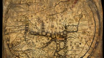
Hereford Mappa Mundi
The Hereford Mappa Mundi is a world map dating to c. 1300. It is...

Image
Anglo-Saxon Map of the World
The "Cotton Map" is an Anglo-Saxon map of the world produced during...

Image
Map of the Inca Empire - Expansion and Roads
The Inca Empire (c. 13th–16th century CE) expanded from a small...
Image
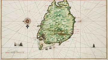
Historical Map of São Tomé
A 1665 map drawn by Johannes Vingboons of the island of São Tomé...

Image
Map of Viking Exploration, 8th-11th Century
This map illustrates the sweep of Viking exploration between the...

Image
1584 Map of the Azores
A c.1584 map of the Azores archipelago in the North Atlantic. The...