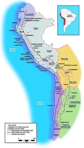
The Inca road system formed a network known as the royal highway or qhapaq ñan, which became an invaluable part of the Inca empire. Roads facilitated the movement of armies, people, and goods across plains, deserts, and mountains. They connected settlements and administrative centres, and provided an important physical symbol of imperial power and control.
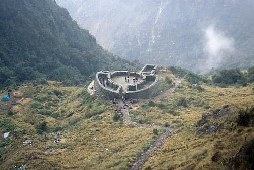
Inca roads were well-built and lasting, with many incorporating bridges, causeways, and stairways. Many also had small stations (chaskiwasi) and sometimes larger, more luxurious complexes (tambos) dotted along every 20 km or so, where travellers could spend the night and refresh. The Andean road system is listed by UNESCO as a World Heritage Site.
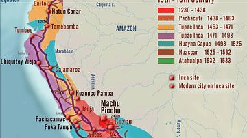
Inca roads covered over 40,000 kilometres (25,000 miles), principally in two main highways running north to south across the Inca Empire, which eventually spread over ancient Peru, Ecuador, Chile, Bolivia, and Argentina. One highway ran down the coast, and the other wound through the highlands. Another important route ran east from Quito (Ecuador) across to Mendoza (Argentina), and there was also a major route along the plains of the northern coast. Criss-crossing these main roads were some 20 other secondary routes and many smaller trails besides. Roads were also built which went beyond Inca-controlled settlements and led to outside territory, perhaps to facilitate trade with, or military operations against, neighbouring peoples. Along some of the more important highways, milestones marked each Inca unit of distance, the topo, equivalent to 7 kilometres.
Although some Inca roads used older routes such as those built by the earlier Wari, Tiwanaku, and Chimu cultures, the Incas were also creative in their positioning of routes and were not afraid to cross new and unpopulated terrain. Inca engineers were also undaunted by geographical difficulties and built roads across ravines, rivers, deserts, and mountain passes up to 5,000 metres high.
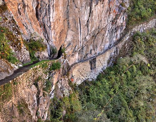
Inca roads were built without the benefit of sophisticated surveying equipment, using only wooden, stone, and bronze tools. As they were built in different geographical zones using local populations, the roads are, consequently, not uniform in construction design or materials. The width of most roads varies from one to four metres, although some could be much bigger, such as the 15-metre wide highway in the Huanuco Pampa province. Sometimes there are also two or three roads constructed in parallel, especially near the larger urban centres. Flattened road beds - often raised - were usually made using packed earth, sand, or grass. The more important roads were finished with precisely arranged paving stones or cobbles. Roads were typically edged and protected with small stone walls, stone markers, wooden or cane posts, or piles of stones. Drainage was provided by frequent drains and culverts, which drew off rainwater from the road surface, channelling it either along or under the road. When crossing wetlands, roads were often supported by buttress walls or built on causeways. Bridges of stone or reeds were also constructed to cover distances in a more direct route as were large, stone, llama-friendly staircases in mountainous terrain. There was even an appointed official, the Chaka Suyuyuq, responsible for inspecting the empire's bridges.
Inca roads are very often more elaborate & well-constructed than was actually necessary, no doubt, so as to impress travellers & conquered peoples of the superiority of Inca culture.
Generally, and despite their reputation for Roman-like long straight roads, Inca roads tended to follow natural contours as the straight stretches of road are rarely more than a few kilometres long. It is also noteworthy that Inca roads are very often more elaborate and well-constructed than was actually necessary. This attention to detail was almost certainly in order to impress travellers and conquered peoples of the superiority of Inca culture as felt by the lords of Cuzco.
Surely one of the most impressive sights and showcases for Inca engineering must have been the many rope suspension bridges which crossed perilous ravines. These were built using braids of reed or grass rope with wooden and fibre flooring. Perhaps the most famous crossed the Apurimac River near Cuzco and measured 45 metres in length. Suspension bridges were often built in pairs, perhaps with one bridge for commoners and one for nobles. An alternative to such bridges was the oroya, a suspended basket which transported two or three people at a time over a greater distance than could be reached with a rope bridge. Local populations were given the responsibility of maintaining these perishable structures each year as part of their imperial tribute.
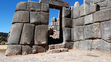
Inca Road Rest Station
Tyler Bell (CC BY-SA)
Road Users
The extensive reach of the road network allowed the Incas to better move armies across their territories in order to further expand the empire or maintain order within it. Trade goods and tribute from conquered peoples - both goods and people - could also be easily transported to and from the major Inca centres, typically using llama caravans and porters (there were no wheeled vehicles). Inca administrative officials also travelled along the roads in order to dispense justice or maintain records such as local agricultural production, tribute quotas, and censuses. Ordinary people were not permitted to use the roads for private purposes unless they had official permission. They also sometimes had to pay tolls for the privilege, especially at bridges.
Another interesting feature of Inca roads was the use of runners (chaski or chasquis). Moving as fast as they could, they operated in relays, passing information to a fresh runner stationed every six to nine kilometres. However, it was not only messages that were carried between population centres but also such perishable items as fresh fish and seafood for the tables of Inca nobles. With this system, information (and fish) could travel up to 240 kilometres in a single day. Messages carried over long distances would have involved hundreds of oral exchanges, and to preserve the correct meaning of the original message, quipu - a coded assembly of strings and knots - were probably used to help the memory of the runners.
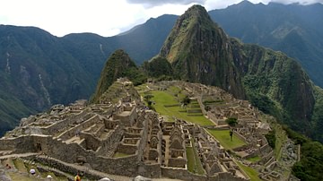
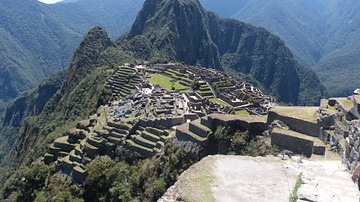
Many sections of the Inca road network survive today and are still used by pedestrians, especially near such sites as Machu Picchu, where large stone stairways and bridges give access to the site for modern tourists. In addition, some of the original Inca routes have had modern roads built directly over them, illustrating the skills and vision for crossing terrain and distances possessed by Inca engineers and road builders.
Editorial Review
This article has been reviewed by our editorial team before publication to ensure accuracy, reliability and adherence to academic standards in accordance with our editorial policy.
Mark is a full-time author, researcher, historian, and editor. Special interests include art, architecture, and discovering the ideas that all civilizations share. He holds an MA in Political Philosophy and is the WHE Publishing Director.
World History Encyclopedia is a non-profit organization. For only $5 per month you can become a member and support our mission to engage people with cultural heritage and to improve history education worldwide.
Written by Baby Professor, published by Baby Professor (2020)
$16.96
World History Encyclopedia is an Amazon Associate and earns a commission on qualifying book purchases.
Cite This Work
APA Style
Cartwright, M. (2014, September 08). The Inca Road System.
World History Encyclopedia. Retrieved from https://www.worldhistory.org/article/757/the-inca-road-system/
Chicago Style
Cartwright, Mark. "The Inca Road System."
World History Encyclopedia. Last modified September 08, 2014.
https://www.worldhistory.org/article/757/the-inca-road-system/.
MLA Style
Cartwright, Mark. "The Inca Road System."
World History Encyclopedia. World History Encyclopedia, 08 Sep 2014. Web. 16 Apr 2024.
License & Copyright
Submitted by Mark Cartwright, published on 08 September 2014. The copyright holder has published this content under the following license: Creative Commons Attribution-NonCommercial-ShareAlike. This license lets others remix, tweak, and build upon this content non-commercially, as long as they credit the author and license their new creations under the identical terms. When republishing on the web a hyperlink back to the original content source URL must be included. Please note that content linked from this page may have different licensing terms.