---
title: Periplus of the Euxine Sea
author: Carole Raddato
source: https://www.worldhistory.org/article/2344/periplus-of-the-euxine-sea/
format: machine-readable-alternate
license: Creative Commons Attribution-NonCommercial-ShareAlike (https://creativecommons.org/licenses/by-nc-sa/4.0/)
updated: 2024-09-03
---
# Periplus of the Euxine Sea
_Authored by [Carole Raddato](https://www.worldhistory.org/user/FollowingHadrian/)_
The *Periplus of the Euxine Sea* (Circumnavigation of the Black Sea) is a description of [trade](https://www.worldhistory.org/disambiguation/trade/) routes along the shores of the Black Sea written by [Arrian](https://www.worldhistory.org/Arrian/) of Nicomedia (Lucius Flavius Arrianus), a historian and philosopher [writing](https://www.worldhistory.org/writing/) in the early 2nd century CE. This geographical treatise provides valuable insights into the geography, [culture](https://www.worldhistory.org/disambiguation/culture/), and commerce of the Black Sea region, known as the Euxine Sea in antiquity, with notices of rivers, harbours, and tribes under the supervision of client kings.
[  Map of a Circumnavigation of the Black Sea c. 130 CE Simeon Netchev (CC BY-NC-ND) ](https://www.worldhistory.org/image/18252/map-of-a-circumnavigation-of-the-black-sea-c-130-c/ "Map of a Circumnavigation of the Black Sea c. 130 CE")### Background
Control over the Lazica (Colchis) region was transferred in 81 CE by Emperor [Domitian](https://www.worldhistory.org/domitian/) (r. 81-96 CE) to the [Roman](https://www.worldhistory.org/disambiguation/Roman/) province of Cappadocia in eastern [Anatolia](https://www.worldhistory.org/Asia_Minor/), bordering [Armenia](https://www.worldhistory.org/armenia/). Cappadocia was a frontier province with legions, legionary camps, and a chain of frontier stations garrisoned by auxiliary troops. In 130 CE, [Roman emperor](https://www.worldhistory.org/Roman_Emperor/) [Hadrian](https://www.worldhistory.org/hadrian/) (r. 117-138 CE) appointed his life-long friend and close adviser, Lucius Flavius Arrianus, as the Roman governor of Cappadocia. Arrian (born in 86 CE) was a native of Nicomedia, the capital of the Roman province of Bithynia, a [city](https://www.worldhistory.org/city/) situated at the extremity of a bay of the Propontis (Sea of Marmara) on the Asiatic side. Arrian was a member of the [Greek](https://www.worldhistory.org/disambiguation/greek/) literary elite (a pupil of [Epictetus](https://www.worldhistory.org/Epictetus/)) and the Roman imperial administration. His political and public career culminated under Hadrian, becoming [consul](https://www.worldhistory.org/Consul/) in 129 or 130 CE and serving as governor of Cappadocia from 130/1 to 136/7 CE.
The governor's duty was to protect the frontier and maintain the highly efficient state of defence of the forts and camps. Arrian commanded two legions stationed in Cappadocia, the XII Fulminata based at Melitene and the XV Apollinaris at Satala, which safeguarded routes into Roman territory from Armenia and the neighbouring [Parthian Empire](https://www.worldhistory.org/Parthia_(Empire)/). The Cappadocian military force was also responsible for garrisoning the territory of Lazica (Colchis) on the eastern Black Sea coast as far as Dioscurias and assisting the allied kingdom of Caucasian [Iberia](https://www.worldhistory.org/disambiguation/iberia/). Additionally, the Pontic Fleet (*Classis Pontica*), with its headquarters at [Trapezus](https://www.worldhistory.org/Trapezus/) (known later as Trebizond, and Trabzon in the present day) secured the southeast Black Sea area and protected the grain supply from Crimea (historically known as Tauris and Taurica). Three of Arrian's extant works belong to the period of his governorship, including the *Periplus of the Euxine Sea*, a unique report composed in 131 CE in the first year of his command.
### Form & Purpose
The *Periplus of the Euxine Sea* appears in the form of a series of letters from Arrian to Hadrian, his friend and emperor, giving him a geographical and topographical survey of the coast of the Black Sea. Probably commissioned by the emperor himself, the *Periplus* was written in Greek as a literary complement to a report Arrian made in Latin, the appropriate language for military dispatches. The Greek account was written to the Philhellenic emperor in a more personal tone, as a friend to a friend. The official Latin report has not survived.
[ 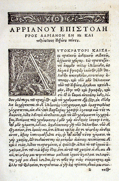 Periplus of the Euxine Sea by Arrian UB Basel (Public Domain) ](https://www.worldhistory.org/image/18248/periplus-of-the-euxine-sea-by-arrian/ "Periplus of the Euxine Sea by Arrian")Shortly before Arrian took up office as legate of Cappadocia, Hadrian had inspected that part of the [Roman Empire](https://www.worldhistory.org/Roman_Empire/), visiting the [Roman army](https://www.worldhistory.org/Roman_Army/) camps along the eastern frontier before focusing on other areas. Arrian's duty was to continue Hadrian's inspection tour of the frontier along the eastern Black Sea and the Caucasus. The purpose of the voyage would have been both military and diplomatic: to check on the military garrisons and anchorages in case of a military expedition to the region and to strengthen the influence of [Rome](https://www.worldhistory.org/Rome/) over the tribes and client kingdoms. The *Periplus* also focused on strategic and topographical information. It served as a maritime guide, outlining navigational routes, ports, and noteworthy landmarks along the Black Sea's shores, emphasising economic activities and resources. Arrian's fleet probably consisted of two-row liburnians and large triremes. They sailed early in the morning from the mouths of the rivers.
Arrian modelled his writing style after the 4th-century BCE philosopher and historian [Xenophon](https://www.worldhistory.org/xenophon/), earning the nickname "the Second Xenophon". Like Xenophon before him, Arrian reached the southeast corner of the Black Sea coast at Trapezus. The opening passage of his *Periplus* glances at the most famous passage in Xenophon's *Anabasis*, the Ten Thousand's shouting of joy, "*Thalatta! Thalatta!*" ("Sea! Sea!"). Arrian begins with these words addressed to Hadrian:
> Arrian, to the Emperor [Caesar](https://www.worldhistory.org/disambiguation/caesar/) [Trajan](https://www.worldhistory.org/trajan/) Hadrian [Augustus](https://www.worldhistory.org/augustus/), greetings. We came to Trapezus, a Greek city, as Xenophon says, founded on the sea, a colony of the Sinopeans; and gladly we looked down on the Euxine Sea from the very same spot as both Xenophon and you. (1.1)
### The Route Described
Arrian's *Periplus* is divided into three sections, consisting of three separate voyages in a discontinuous anti-clockwise journey around the Black Sea: along the coast of Trapezus to Sebastopolis (chapters 1-11), from the Thracian Bosporus to Trapezus (chapters 12-17), and from Sebastopolis to [Byzantium](https://www.worldhistory.org/Byzantium/) (chapters 18-25). Only the first part may describe an actual voyage of Arrian as a [Roman government](https://www.worldhistory.org/Roman_Government/) official. It is the longest and the most interesting part of the *Periplus*, written in the first-person narrative. The other two voyages were perhaps executed by different people, explaining their spatial movement discontinuity and impersonal narrative style. Much of the *Periplus* is taken up by lists of rivers, harbours, and [cities](https://www.worldhistory.org/city/), with distances between them, as well as sanctuaries and tribes of people living in the area. Arrian also alludes to local history and stories from [Greek mythology](https://www.worldhistory.org/Greek_Mythology/) ([Jason & the Argonauts](https://www.worldhistory.org/article/425/jason--the-argonauts/), [Medea](https://www.worldhistory.org/Medea/), [Prometheus](https://www.worldhistory.org/Prometheus/)) and often quotes [Homer](https://www.worldhistory.org/homer/).
[  Recreation of a Roman Port Ancient History Magazine / Karwansaray Publishers (Copyright) ](https://www.worldhistory.org/image/11762/recreation-of-a-roman-port/ "Recreation of a Roman Port")### Part 1: Tour of Colchis: From Trapezus to Sebastopolis (1-11)
Arrian began his journey of inspection at Trapezus before sailing east and north along the coast, stopping at military forts and reviewing troops. In Trapezus, the governor visits the local sanctuary devoted to the Greek [god](https://www.worldhistory.org/God/) [Hermes](https://www.worldhistory.org/Hermes/) and the imperial cult, which he says has fallen into disrepair. He comments on the statue of Hadrian, constructed in a pose pointing towards the sea: "Your statue bears no resemblance to the original, and the execution is in other respects but indifferent. Send therefore a statue worthy to be called Yours" (1.3-4). He was also unimpressed with the altars made of "rough stone" and commented on the inscription, which was "incorrectly written, as is common among barbarous people" (1.2).
Trapezus was the starting point of the Pontus-Caucasian defence system extending along the coast of Colchis. Sailing east, the first place that Arrian reached was the nearby port town of Hyssus (or Hyssou Limen), 180 stadia from Trapezus (34 km / 23 mi), where a small military garrison was stationed. He had the soldiers perform military exercises with a display of javelin throwing, evoking Hadrian's observations and address at Lambaesis in Numidia in 128 CE.
[ 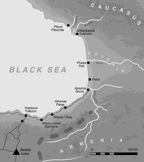 The Caucasian Frontier of the Roman Empire David Breeze and Kurt Schaller (CC BY-NC-SA) ](https://www.worldhistory.org/image/18271/the-caucasian-frontier-of-the-roman-empire/ "The Caucasian Frontier of the Roman Empire")Arrian's fleet then anchored at the Greek sanctuary of [Athena](https://www.worldhistory.org/athena/) at Athenae, where he experienced a violent storm of thunder and lightning that lasted for two days and destroyed one [trireme](https://www.worldhistory.org/trireme/). At the fortress of Apsarus, he paid the soldiers (there were five cohorts, about 2,500 troops) and inspected their weapons and provisions. Apsarus controlled an important east-west route and was more heavily defended than other military outposts on this frontier. A few years later, in 135 CE, Arrian was to deploy the Cappadocian legions and lead a march to protect the province against the invading Alans. He would make Apsarus his command post. Arrian derives the name of this place from Absyrtus, the younger brother of Medea, whom she is said to have murdered at this place and whose [grave](https://www.worldhistory.org/burial/) was still to be seen.
[  Remains of the Apsarus Roman Fort Carole Raddato (CC BY-NC-SA) ](https://www.worldhistory.org/image/18191/remains-of-the-apsarus-roman-fort/ "Remains of the Apsarus Roman Fort")Arrian then breaks off from his narrative to list all the rivers flowing into the Black Sea between Trapezus and Phasis and the distances between them. Sailing from Apsarus, Arrian reached Phasis (a Greek colony from Miletus) at the mouth of the river of the same name, a voyage of 360 stadia (67 km / 46 mi). He reports that he constructed a ditch to protect the anchorage and the civilian settlement that had grown up around the fort.
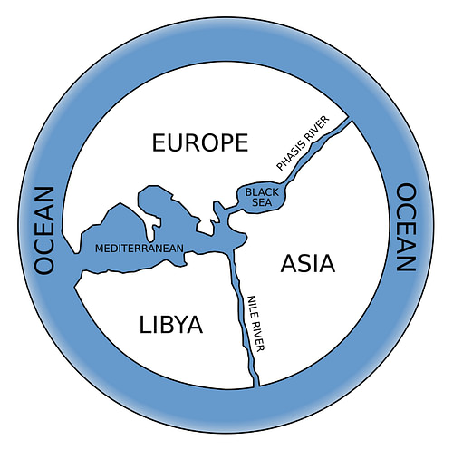
[  View of the Black Sea towards Phasis Carole Raddato (CC BY-NC-SA) ](https://www.worldhistory.org/image/18272/view-of-the-black-sea-towards-phasis/ "View of the Black Sea towards Phasis")Arrian also describes the unusual properties of the Phasis River, which is light and changeable in colour and exceptionally soft and sweet. The Phasis, which flowed down through the Caucasus Mountains, was the most important river in Colchis, dividing [Europe](https://www.worldhistory.org/europe/) from Asia on [Anaximander](https://www.worldhistory.org/Anaximander/)'s world map. At Phasis, Arrian was shown the iron anchor of Jason's ship, the *Argo*, but he expressed his scepticism that the relic was genuine as it looked too recent, and he added that "no other monument is now to be found there of the fabulous history of Jason." (9.2-3).
[  Anaximander World Map Bibi Saint-Pol (Public Domain) ](https://www.worldhistory.org/image/18224/anaximander-world-map/ "Anaximander World Map")From Phasis, Arrian sailed to Dioscurias (another Milesian colony), "now called Sebastopolis" (10.4), the last camp in the Roman territory when sailing along the eastern coast of the Black Sea. As his trireme neared the anchorage, Arrian saw the highest peak of the Caucasus Mountains, "called Strobilus" (11.4), where Prometheus was bound. According to the myth, [Zeus](https://www.worldhistory.org/zeus/) punished Prometheus for giving humanity fire by chaining the [Titan](https://www.worldhistory.org/Titan/) to a rock and having an eagle eat his liver. As the liver grew back each night, the eagle returned to eat it again the next day. The mountain was Mount Elbrus in the northwest of the Caucasus, although Mount Kazbek in Eastern Georgia is also said to be where Prometheus was chained. Mount Kazbek is associated in Georgian folklore with the mighty hero Amirani, the Georgian version of Prometheus, who was chained on the mountain for the same reasons.
[  Mount Kazbeg in the Caucasus Mountains, Georgia Carole Raddato (CC BY-NC-SA) ](https://www.worldhistory.org/image/18247/mount-kazbeg-in-the-caucasus-mountains-georgia/ "Mount Kazbeg in the Caucasus Mountains, Georgia")At Sebastopolis, Arrian paid the soldiers and watched the cavalry leaping upon horses. He visited the sick, verified the grain supply, and, concerned about security and the threat of invasion, checked the city walls and the ditch to ensure they were adequate for defence. Arrian calculated that Sebastopolis was about 2,260 stadia (422 km / 286 mi) from the Trapezus naval base. Arrian then gives a sequential list of native tribes on the eastern coast in Colchis ruled by chiefs subject to Rome (11.3-3). Under Trajan (r. 98-117 CE) and Hadrian, the Romans established relations with Colchian tribes. He names the three client rulers recognised by Hadrian: Malassas of the Lazi, Rhezmegas of the Abasci, and Spadagas of the Sanigs. After inspecting Sebastopolis, Arrian returned with his squadron to Trapezus.
### Part 2: From the Thracian Bosporus to Trapezus (12-17)
The second part of the *Periplus* contains a detailed guide to places and rivers between the mouth of the Bosporus and Trapezus. It covers what should have been the first portion of a conventional circumnavigation of the Black Sea. Whether this section is written down from the author's personal experience is not ascertained. However, some scholars think this chapter may result from his own examinations in his journey to Trapezus when he took up his post in Cappadocia. Additionally, as a native of Bithynia, he would have had opportunities to become acquainted with people and towns along the south shore of the Black Sea. About a third of this coastline belonged to Bithynia. In this section, Arrian constantly references his favourite hero, Xenophon and the march of the Ten Thousand Greek mercenaries from Trapezus to Byzantium along this coast.
[ 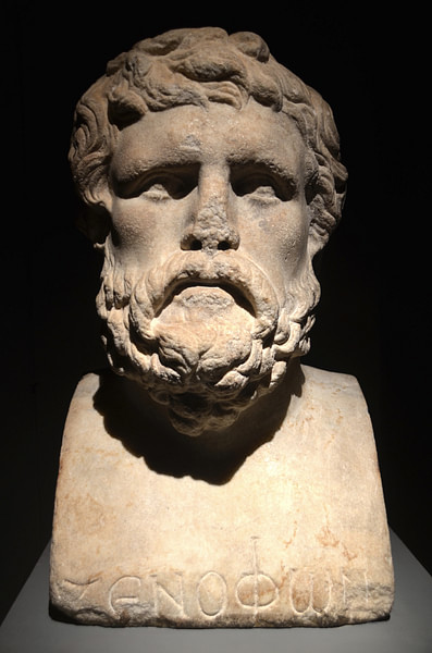 Bust of Xenophon Carole Raddato (CC BY-NC-SA) ](https://www.worldhistory.org/image/18242/bust-of-xenophon/ "Bust of Xenophon")Among the cities and harbours listed in part two of the *Periplus* are Heraclea Pontica, "a Dorian Greek city, a colony of the Megareans" (13.3) at the mouth of the Lycus River; Tios, "a colony of the Milesians" (13.5) at the mouth of the river Billaeus River; [Amastris](https://www.worldhistory.org/Amastris/), a Greek city 90 stadia from the river Parthenius within the boundary of Paphlagonia "where there is a port for ships" (14.1); Sinope, "a colony of the Milesians" (14.5); Amisus, "a Greek city, and an Athenian colony" (15.3) between the Halys and [Iris](https://www.worldhistory.org/Iris/) river deltas; and Cotyora, which Xenophon mentioned as a colony of the Sinopians. [Herodotus](https://www.worldhistory.org/herodotus/) made the river Halys famous as the boundary of the kingdom of [Croesus](https://www.worldhistory.org/croesus/), who ruled over all the people living to the west of the river. In chapter 15, Arrian also mentions the Thermodon River, "on whose banks the [Amazons](https://www.worldhistory.org/amazon/) are said to have lived" (15.3). The river flows into the Black Sea about 50 km (34 mi) east of Amisus. As a river god, Thermodon was the son of [Oceanus](https://www.worldhistory.org/Oceanus/) and [Thetis](https://www.worldhistory.org/Thetis/). He is depicted on the reverse of a [bronze](https://www.worldhistory.org/disambiguation/bronze/) medal of [Antinous](https://www.worldhistory.org/antinous/) minted in Amisus.
[  Fortifications Walls of Sinope Carole Raddato (CC BY-NC-SA) ](https://www.worldhistory.org/image/18245/fortifications-walls-of-sinope/ "Fortifications Walls of Sinope")In 123 CE, Hadrian stopped at some of these harbours after he inspected the Cappadocian frontier and visited Trapezus. In chapter 16 of the *Periplus*, he mentions that Trapezus had a new harbour under construction: "There you are building a harbour; for before, there was a moor one could only ride at anchor in the summer." (16.5). It is one of the only personal comments that Arrian makes.
### Part 3: From Dioscuras to Byzantium (18-25)
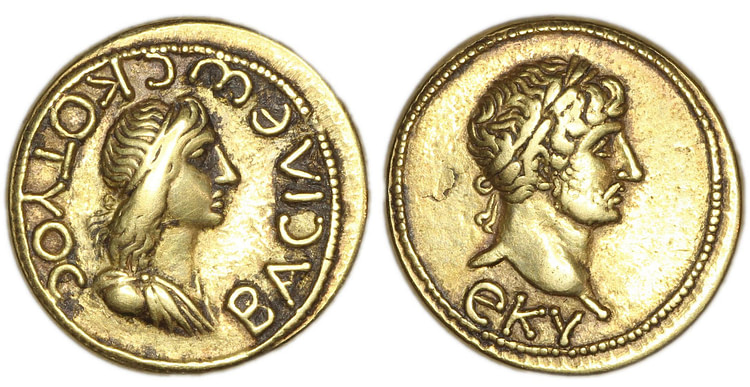
The third and last part of the *Periplus* completes the circuit of the Black Sea, picking up the narrative where it was left at the end of the first section, starting at Sebastopolis and continuing all the way to Byzantium. This third section is the longest stretch of the Black Sea littoral. Arrian did not undertake this voyage as the north coastline was an area beyond Roman control. However, on hearing about the [death](https://www.worldhistory.org/disambiguation/Death/) of Cotys II, Hadrian's client king in the Cimmerian Bosporus, Arrian thought it worthwhile to include information on the journey to his kingdom. [Tiberius](https://www.worldhistory.org/Tiberius/) [Julius](https://www.worldhistory.org/disambiguation/Julius/) Cotys, who reigned from 123/4 CE until his death in 131/2 CE, was given his crown by the emperor, and his successor would have to be formally recognised by Rome. The Bosporan kingdom was an important client of Rome, with prosperous merchant towns furnishing wheat, clothing, wine and slaves to the [Empire](https://www.worldhistory.org/empire/) and protecting it from raiding tribes such as the Alans.
[  Gold Coin of Bosporan king Cotys II The Trustees of the British Museum (CC BY-NC-SA) ](https://www.worldhistory.org/image/18259/gold-coin-of-bosporan-king-cotys-ii/ "Gold Coin of Bosporan king Cotys II")Sailing north from Sebastopolis, Arrian passed along the mountainous coastline below the Caucasus. Pityus was the first anchorage to the northwest, 350 stadia (about 65 km / 44 mi), where a detachment of Legio XV Apollinaris was stationed. At this point, in chapter 18, Arrian notes that this large tract of the Black Sea coast and the adjacent mountains was ruled by a tribal people called the Zilchi, whose leader, Stachemphax, was recognised as a king by Hadrian. Arrian then describes the coast by naming cities, harbours, islands, rivers, and the distances between them, from the Bosporan Kingdom (Crimea) to the mouth of the Danube. The southern coast of the Crimean Peninsula was dotted with Greek cities: Panticapaeum, Theodosia, Cercinitis, and Chersonesus. Panticapaeum lies 60 stadia (11 km / 8 mi) from the Tanais River, which flows to Maeotis Lake (Sea of Azov) and "is said to divide Europe from Asia" (19.1). However, Arrian recalls the passage from [Greek tragedy](https://www.worldhistory.org/Greek_Tragedy/) playwright [Aeschylus](https://www.worldhistory.org/Aeschylus/)' *Prometheus Unbound* in which not the Tanais but the Phasis is called the boundary of Asia (19.2).
[ 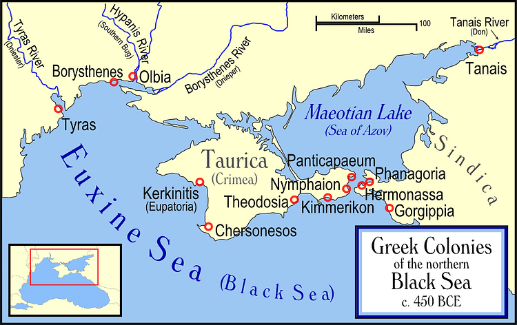 Greek Colonies of the Northern Black Sea MapMapster (GNU FDL) ](https://www.worldhistory.org/image/72/greek-colonies-of-the-northern-black-sea/ "Greek Colonies of the Northern Black Sea")[  Chersonesus Alexxx1979 (CC BY-SA) ](https://www.worldhistory.org/image/18266/chersonesus/ "Chersonesus")Continuing westward, Arrian mentions another Greek town, Olbia, which lies on the western side of the Borysthenes River (Dnieper) near its mouth. Then came Odessus, a trade settlement established by the Greek city of Histria, where there was a port for ships. To the north of the first mouth of the river Ister (Danube) lay the Island of [Achilles](https://www.worldhistory.org/achilles/), also known as Leuke (presumably Snake Island in Ukraine). The island hosted a [temple](https://www.worldhistory.org/temple/) to Achilles with a wooden statue inside, for "it is said that Thetis gave up this island to her son Achilles, by whom it was inhabited" (21.1). There were also many offerings in the temple and inscriptions in the Greek and Latin languages in honour of both Achilles and [Patroclus](https://www.worldhistory.org/Patroclus/). Arrian adds that people come to the island and sacrifice or set animals free in honour of Achilles and further explains that Achilles appears to those who sail by the island as hallucinations or in their dreams.
[  Achilles Tending to Patroclus ArchaiOptix (CC BY-SA) ](https://www.worldhistory.org/image/14193/achilles-tending-to-patroclus/ "Achilles Tending to Patroclus")From the mouth of the Ister, the Black Sea coast continued south towards Moesia and neighbouring Thrace. It was lined with cities and ports: Histria, Tomis, the most famous Greek colony on the west coast of the Black Sea where Augustus (r. 27 BCE to 14 CE) banished the poet [Ovid](https://www.worldhistory.org/ovid/), and Callatis, the port of the Carians, Odessos "where there is a road for ships" (24.4). Then, the eastern offshoots of Mount Haemus, the Balkan range of central Bulgaria, come very close to the shore before reaching [Apollonia](https://www.worldhistory.org/disambiguation/Apollonia/), a colony of the Milesians formerly remarkable for its colossal statue of [Apollo](https://www.worldhistory.org/apollo/), and Salmydessus. About Salmydessus, Arrian notes that Xenophon campaigned here against Seuthes the Thracian and that the city lacked a good harbour.
[  Histria Carole Raddato (CC BY-NC-SA) ](https://www.worldhistory.org/image/18265/histria/ "Histria")On approaching the narrow strait of the Thracian Bosporus are the Cyanean islands, a pair of rocks (also known as the Symplegades) once reputed to clash together whenever a ship went through. Arrian reports that the *Argo*, which carried Jason to Colchis, passed through them. Arrian ends his account of the Black Sea circumnavigation at Byzantium after mentioning the Temple of Zeus Ourios (Zeus, granter of favouring winds), where Jason and the Argonauts dedicated an altar to the Twelve Gods on his return voyage from Colchis.
#### Editorial Review
This human-authored article has been reviewed by our editorial team before publication to ensure accuracy, reliability and adherence to academic standards in accordance with our [editorial policy](https://www.worldhistory.org/static/editorial-policy/).
## Bibliography
- [Arrian & Liddle, Aidan. *Arrian.* Bristol Classical Press, 2003.](https://www.worldhistory.org/books/1853996610/)
- [Birley, Anthony R. *Hadrian .* Routledge, 2000.](https://www.worldhistory.org/books/0415228123/)
- [Stadter, Philip A. *Arrian of Nicomedia.* The University of North Carolina Press, 1980.](https://www.worldhistory.org/books/0807813648/)
- Tim Rood. *Black Sea variations: Arrian's Periplus.* The Cambridge Classical Journal, Volume 57, 2011, 137-163.
## About the Author
Carole maintains the popular ancient history photo-blog Following Hadrian, where she travels the ancient world in the footsteps of Emperor Hadrian.
- [Facebook Profile](https://www.facebook.com/FollowingHadrian)
- [X/Twitter Profile](https://twitter.com/carolemadge)
## Questions & Answers
### What is a Periplus?
A Periplus is a navigation guide or a written description of a sea route, including details about landmarks, ports, and distances between them. It was commonly used by sailors and traders in ancient times for maritime navigation.
### Who wrote the Periplus of the Euxine Sea?
The Periplus of the Euxine Sea was written by Arrian of Nicomedia, a Greek historian and philosopher who lived in the 2nd century CE. Arrian is recognised as one of the most renowned authors of the Roman Empire for his extensive works on Alexander the Great.
### What is the Euxine Sea called today?
The Euxine Sea is known as the Black Sea today. The name Euxine comes from the Greek word 'Euxeinos' and the full Greek name of the Black Sea was 'Pontos Euxeinos', meaning "the hospitable sea". However, before colonising the area, the Greeks called the Black Sea 'Pontos Axeinos', "the inhospitable Sea", due to its difficult navigation and hostile tribes (Strabo 7.3.6).
## External Links
- [ToposText](https://topostext.org/work/203)
- [Autumn AD 123 – Hadrian reaches Trapezus and sails westwards along the Pontic coast (#Hadrian1900) FOLLOWING HADRIAN](https://followinghadrian.com/2023/10/19/autumn-ad-123-hadrian-reaches-trapezus-and-sails-westwards-along-the-pontic-coast-hadrian1900/)
## Cite This Work
### APA
Raddato, C. (2023, December 19). Periplus of the Euxine Sea. *World History Encyclopedia*.
### Chicago
Raddato, Carole. "Periplus of the Euxine Sea." *World History Encyclopedia*, December 19, 2023. .
### MLA
Raddato, Carole. "Periplus of the Euxine Sea." *World History Encyclopedia*, 19 Dec 2023, .
## License & Copyright
Submitted by [Carole Raddato](https://www.worldhistory.org/user/FollowingHadrian/ "User Page: Carole Raddato"), published on 19 December 2023. The copyright holder has published this content under the following license: [Creative Commons Attribution-NonCommercial-ShareAlike](https://creativecommons.org/licenses/by-nc-sa/4.0/deed.en). This license lets others remix, tweak, and build upon this content non-commercially, as long as they credit the author and license their new creations under the identical terms. When republishing on the web a hyperlink back to the original content source URL must be included. Please note that content linked from this page may have different licensing terms.