---
title: Exploring Roman Morocco
author: Carole Raddato
source: https://www.worldhistory.org/article/2129/exploring-roman-morocco/
format: machine-readable-alternate
license: Creative Commons Attribution-NonCommercial-ShareAlike (https://creativecommons.org/licenses/by-nc-sa/4.0/)
updated: 2023-01-27
---
# Exploring Roman Morocco
_Authored by [Carole Raddato](https://www.worldhistory.org/user/FollowingHadrian/)_
Morocco, then known as [Mauretania](https://www.worldhistory.org/Mauretania/), was annexed by the [Roman Empire](https://www.worldhistory.org/Roman_Empire/) in 40 CE. The Romans in Morocco left a vast legacy with archaeological sites that dot the country's northern landscape, especially Volubilis, with its vestiges of [Roman](https://www.worldhistory.org/disambiguation/Roman/) houses, temples, mosaics, and wide-paved streets. However, three smaller sites exist at Lixus, Sala Colonia, and Banasa.
[  Foundations of a Triumphal Arch at Sala Colonia Carole Raddato (CC BY-NC-SA) ](https://www.worldhistory.org/image/16786/foundations-of-a-triumphal-arch-at-sala-colonia/ "Foundations of a Triumphal Arch at Sala Colonia")### A Brief History of Ancient Morocco
Morocco is a relatively small strip of coastal land located at the northwest tip of [Africa](https://www.worldhistory.org/disambiguation/africa/). Its earliest inhabitants were the indigenous Imazighen (sing. Amazigh), referred to as [Berbers](https://www.worldhistory.org/Berbers/) (from the ancient [Greek](https://www.worldhistory.org/disambiguation/greek/) *barbaros*, meaning "foreign") or Moors. Throughout the centuries, subsequent civilisations penetrated the western [Mediterranean](https://www.worldhistory.org/disambiguation/mediterranean/) and developed commercial relations with the [Berber](https://www.worldhistory.org/Berbers/) tribes. The [Phoenicians](https://www.worldhistory.org/phoenicia/), who sailed from [Tyre](https://www.worldhistory.org/Tyre/) (in present-day Lebanon) and founded a colony at [Carthage](https://www.worldhistory.org/carthage/) (present-day Tunis), were the earliest explorers and the first to settle on the Moroccan coastline as early as the 8th century BCE. [Phoenician colonization](https://www.worldhistory.org/Phoenician_Colonization/) established small trading posts for the [gold](https://www.worldhistory.org/gold/) and ivory [trade](https://www.worldhistory.org/disambiguation/trade/) at Tingis (Tangier), Mogador (Essaouira), Tamuda (Tetouan), and Lixus (Larache). Successors to the Phoenician [civilization](https://www.worldhistory.org/civilization/) in the control of North Africa, the Carthaginians later expanded the lucrative trade routes, in a wide variety of goods, from olive oil to salted fish. Beyond the [Punic](https://www.worldhistory.org/carthage/) enclaves, the influence of Berber leaders grew, and Berber kingdoms emerged.
In 146 BC, having destroyed Carthage, the [Roman Republic](https://www.worldhistory.org/Roman_Republic/) extended its control westwards along the southern coastline of the Mediterranean. The area around northern Morocco became known as Mauretania (Land of the Moors). It prospered especially under the rule of one of the most illustrious Berber kings, the young Roman-educated Numidian prince [Juba II](https://www.worldhistory.org/Juba_II/) (c. 48 BCE to 23 CE), who was appointed by the [Roman emperor](https://www.worldhistory.org/Roman_Emperor/) [Augustus](https://www.worldhistory.org/augustus/) (r. 27 BCE to 14 CE). In 40 CE, Mauretania was annexed to the Roman Empire after the last king Ptolemy (r. 20-40 CE), Juba's son and successor, was executed by his first cousin, the Roman emperor [Caligula](https://www.worldhistory.org/Caligula/) (r. 37-41 CE). Emperor [Claudius](https://www.worldhistory.org/claudius/) (r. 41-54 CE) later divided the Roman province of Mauretania into Mauretania Caesariensis to the east and Mauretania Tingitana to the west, with its capital at Tingis (present-day Tangiers) and its commercial centre at Volubilis. In the 2nd century CE, the greater part of the province was Romanised and urbanised. Thanks to the [Pax Romana](https://www.worldhistory.org/Pax_Romana/), a period of great prosperity followed until deep into the 4th century CE, based largely on [agriculture](https://www.worldhistory.org/disambiguation/Agriculture/) and the export of olive oil and fish sauce (garum).
[  Map of Roman North Africa (146 BCE - 395 CE) Simeon Netchev (CC BY-NC-ND) ](https://www.worldhistory.org/image/16818/map-of-roman-north-africa-146-bce---395-ce/ "Map of Roman North Africa (146 BCE - 395 CE)")[Christianity](https://www.worldhistory.org/christianity/) arrived early in the 2nd century CE and rapidly gained converts in the towns and among the Berbers; within a few centuries, North Africa was Christianised. Roman rule and political control over Mauritania ended abruptly in 429 CE when the province fell to the [Vandals](https://www.worldhistory.org/Vandals/). The [Eastern Roman Empire](https://www.worldhistory.org/Byzantine_Empire/) had recovered some parts of Mauritania from the Vandals and re-established Roman rule before the area fell to Spain's rulers, the [Visigoths](https://www.worldhistory.org/visigoth/), in the early 7th century CE. From the beginning of the 8th century CE, a new set of invaders and a new [religion](https://www.worldhistory.org/religion/) began to make their [mark](https://www.worldhistory.org/disambiguation/Mark/) on Morocco when the Arab army invaded the area and set about converting the Berbers to [Islam](https://www.worldhistory.org/islam/). The first major Islamic ruler of Morocco was Idris I (r. 789-791), a Shiite political exile from Mecca who established his headquarters just outside the ancient Roman [city](https://www.worldhistory.org/city/) of Volubilis in the 8th century CE.
### Volubilis
Volubilis is Morocco's best-preserved archaeological site. Its ruins sit in the middle of a fertile plain just outside modern Meknès in northern Morocco, near the heights of the [Atlas](https://www.worldhistory.org/Atlas/) Mountains. Founded during the Carthaginian [colonization](https://www.worldhistory.org/disambiguation/colonization/), the capital of the Berber Kingdom of Mauretania developed from the 3rd century BCE onwards to become an important outpost of the Roman Empire. It was abandoned 1,400 years later, in the 11th century CE.
[ 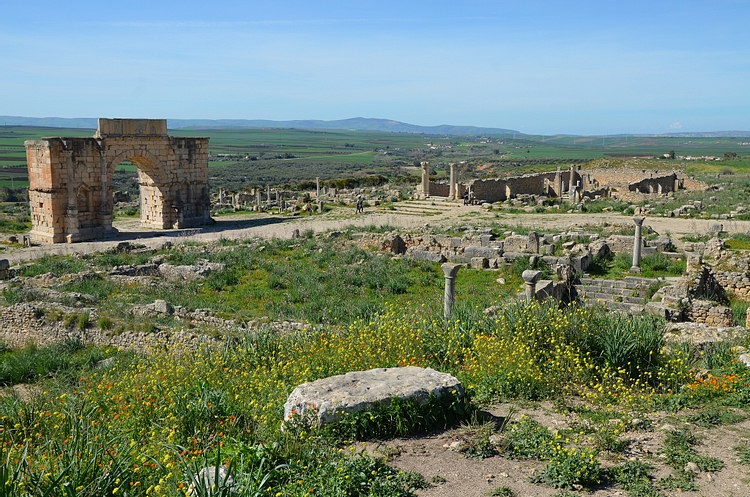 Volubilis Carole Raddato (CC BY-NC-SA) ](https://www.worldhistory.org/image/8246/volubilis/ "Volubilis")Under Roman rule, the city thrived by exporting agricultural products like grains and olive oil and providing wild animals for gladiatorial fights. Its layout is a remarkably coherent example of Roman urban planning, forming a nearly perfect cross-section street plan and distribution of public buildings. It had two [Roman baths](https://www.worldhistory.org/Roman_Baths/), triumphal arches, a forum, and a basilica, all arranged around the Decumanus Maximus, the city's main east-west street. However, it lacked a Roman [theatre](https://www.worldhistory.org/disambiguation/theatre/) or [amphitheatre](https://www.worldhistory.org/amphitheatre/). Sophisticated townhouses paved with mosaics and fronted by shops, bakeries, and oil-pressing complexes formed the urban landscape. At its peak, it probably had 20,000 inhabitants.
Volubilis was declared a UNESCO World Heritage site in 1997. Extensive remains of fine buildings and many beautiful mosaics survive *in situ* at the archaeological site. The most impressive monuments are in the northern part of the site.
**The Capitol**
The Capitol, dedicated to the three chief deities of the [Roman religion](https://www.worldhistory.org/Roman_Religion/), [Jupiter](https://www.worldhistory.org/jupiter/), [Juno](https://www.worldhistory.org/Juno/), and [Minerva](https://www.worldhistory.org/Minerva/), dates back to 218 CE. The Corinthian [temple](https://www.worldhistory.org/temple/) was erected on a tall podium and had 13 steps and a single cella. It was peripteral (a single row of pillars on all sides) and hexastyle (six columns) but was clumsily restored as a four-columned prostyle building. A large porticoed courtyard with an altar in the centre surrounded the Capitol.
[  Capitolium of Volubilis Carole Raddato (CC BY-NC-SA) ](https://www.worldhistory.org/image/16790/capitolium-of-volubilis/ "Capitolium of Volubilis")**The Basilica**
The early 3rd-century CE Basilica was a judicial and administrative building and the meeting place for the city's council or senate. This imposing building is 42.2 m (138 ft) long and 22.3 m (73 ft) wide and originally had two storeys. It lies on the eastern side of the Forum, where a series of stone pedestals carved with Latin inscriptions would have supported statues of members of the local elite.
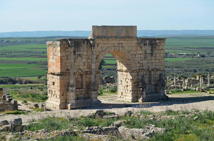
[  The Civil Basilica of Volubilis Carole Raddato (CC BY-NC-SA) ](https://www.worldhistory.org/image/8247/the-civil-basilica-of-volubilis/ "The Civil Basilica of Volubilis")**The Arch of [Caracalla](https://www.worldhistory.org/Caracalla/)**
The marble [triumphal arch](https://www.worldhistory.org/Triumphal_Arch/) is Volubilis' most famous monument. It was erected in 217 CE by [Marcus Aurelius](https://www.worldhistory.org/Marcus_Aurelius/) Sebastenus, the province's governor, in honour of Emperor Caracalla (r. 211-217), who bestowed [Roman citizenship](https://www.worldhistory.org/article/859/roman-citizenship/) on its inhabitants and exempted them from paying taxes. The arch, originally topped with a [chariot](https://www.worldhistory.org/chariot/) drawn by horses, stood over 8 m (26 ft) high at the southwest edge of the Decumanus Maximus.
[  Arch of Caracalla in Volubilis Carole Raddato (CC BY-NC-SA) ](https://www.worldhistory.org/image/8248/arch-of-caracalla-in-volubilis/ "Arch of Caracalla in Volubilis")**The House of [Orpheus](https://www.worldhistory.org/Orpheus/)**
The House of Orpheus is a luxurious villa named after the fantastic Roman [mosaic](https://www.worldhistory.org/Mosaic/) depicting Orpheus playing the [lyre](https://www.worldhistory.org/Lyre/) to an audience of animals and birds. The mosaic of Orpheus embellished the *triclinium* (dining room) of the peristyle house, where the diners would have reclined on couches set against the walls and admired the central mosaic. The house certainly belonged to the city's aristocracy, who showed their wealth through its size, decorative elements (mosaics, marble and [bronze](https://www.worldhistory.org/disambiguation/bronze/) statues, columns), and various economic facilities (shops, bakeries, mills).
[  House of Orpheus, Volubilis Carole Raddato (CC BY-NC-SA) ](https://www.worldhistory.org/image/16791/house-of-orpheus-volubilis/ "House of Orpheus, Volubilis")**The House of the Labours of [Hercules](https://www.worldhistory.org/hercules/)**
The House of the Labours of Hercules is named for the mosaic depicting the twelve labours the demigod had to perform as penance for killing his wife and children. The house was palatial, with 41 rooms covering an area of 2,000 m² (22,000 sq ft).
[  Mosaic of the Labours of Hercules in Volubilis Carole Raddato (CC BY-NC-SA) ](https://www.worldhistory.org/image/16792/mosaic-of-the-labours-of-hercules-in-volubilis/ "Mosaic of the Labours of Hercules in Volubilis")**The House of [Venus](https://www.worldhistory.org/venus/)**
The House of Venus was one of Volubilis' most luxurious residences. It had a set of private baths and a richly decorated interior with fine mosaics showing scenes from [Roman mythology](https://www.worldhistory.org/Roman_Mythology/) and animals. The mosaic of the Voyage of Venus that gave the house its name has been transported to the Archeological Museum at Tangier, but in the next room is a mosaic showing [Diana](https://www.worldhistory.org/diana/) being surprised by the hunter Actaeon while bathing.
[  Mosaic of Diana and Actaeon Carole Raddato (CC BY-NC-SA) ](https://www.worldhistory.org/image/16803/mosaic-of-diana-and-actaeon/ "Mosaic of Diana and Actaeon")**The Decumanus Maximus**
The Decumanus Maximus was the main east-west street in the city. It was paved with footways on either side and was lined with arcaded porticoes and shops.
[  Decumanus Maximus at Volubilis Carole Raddato (CC BY-NC-SA) ](https://www.worldhistory.org/image/16793/decumanus-maximus-at-volubilis/ "Decumanus Maximus at Volubilis")### Lixus
Lixus is the second most important Roman site in Morocco after Volubilis. It is located along the Atlantic coastline near the mouth of the Loukkos River. According to legend, Lixus was the site of the Garden of the [Hesperides](https://www.worldhistory.org/Hesperides/), from which Hercules collected the golden apples of immortality as his eleventh labour.
[  Villa Complex at Lixus Carole Raddato (CC BY-NC-SA) ](https://www.worldhistory.org/image/16806/villa-complex-at-lixus/ "Villa Complex at Lixus")The Roman writer [Pliny the Elder](https://www.worldhistory.org/Pliny_the_Elder/) (23-79 CE) described Lixus as the most ancient Phoenician colony in the far west. However, most of the visible remains date from the Roman era. The city reached its zenith during the reign of Emperor Claudius (41-54 CE) when it became a Roman colony and began exporting the fish-based garum sauce. The salt-fishing factory consisted of closely-spaced complexes with a salting capacity of over one million litres, making it the largest garum producer in the western Mediterranean. In the 3rd century CE, Lixus became nearly fully Christian. The site was abandoned in the 7th century CE and later became known to Muslims as Tuchummus when a mosque was erected.
[  Garum Factory in Lixus Carole Raddato (CC BY-NC-SA) ](https://www.worldhistory.org/image/16804/garum-factory-in-lixus/ "Garum Factory in Lixus")The excavated zones (62 hectares / 153 acres) constitute only a quarter of the total area of the ancient city. Immediately upon entering the site is the lower town with the remains of garum-making facilities. A track leads up the hill to the [acropolis](https://www.worldhistory.org/Acropolis/), passing on its way a small amphitheatre with a semi-circular *cavea* designed to house theatrical plays and gladiatorial combats. Baths were originally built into the side of the arena, with some traces of mosaic flooring. The acropolis mound formed the original settlement nucleus at Lixus. A sanctuary to Hercules/[Melqart](https://www.worldhistory.org/Melqart/) and a [palace](https://www.worldhistory.org/disambiguation/palace/) villa probably belonging to a courtier under Juba II sat at its top. They are also ruins of the Paleochristian church, underground cisterns, and traces of pre-Roman structures.
[  Roman Amphitheatre at Lixus Carole Raddato (CC BY-NC-SA) ](https://www.worldhistory.org/image/16805/roman-amphitheatre-at-lixus/ "Roman Amphitheatre at Lixus")### Banasa
Banasa, more strictly [Julius](https://www.worldhistory.org/disambiguation/Julius/) Valentia Banasa, was an ancient city situated on the road from Tingis (Tangiers) to Sala (Rabat). Its ruins are located on the southern bank of the river Sebou, which Pliny described as "*Sububus magnificus et nauigabilis*" (a fine river available for navigation). Banasa was one of the three Roman colonies in Mauretania established by Augustus between 33 and 27 BCE for veterans of the [Battle of Actium](https://www.worldhistory.org/Battle_of_Actium/).
[  Forum of Banasa Carole Raddato (CC BY-NC-SA) ](https://www.worldhistory.org/image/16815/forum-of-banasa/ "Forum of Banasa")Banasa was a centre of [pottery](https://www.worldhistory.org/pottery/) production from the 3rd century BCE and was a prosperous and bustling commercial town until the end of the 3rd century CE. The archaeological excavations undertaken between 1933 and 1956 exposed the remains of the Roman era. The uncovered buildings include a trapezoidal paved forum flanked to the north by a rectangular basilica, a capitol (the colony's main temple) with seven *cellae*, an urban bath complex, a *macellum* (marketplace), and streets in a regular pattern. Many of the buildings date from the early 3rd century CE. The beautiful mosaics that decorated the buildings are now on display at the Rabat Archaeological Museum.
### Sala Colonia
One of Morocco's most beautiful historical ruins can be seen on the outskirts of Rabat in Chellah, a medieval fortified Muslim necropolis. The site contains the ruins of an ancient port city referred to as Sala by the renowned Greek geographer Ptolemy (c. 100 to c. 170 CE). The Phoenicians were the first to settle on this site on the south bank of the Bou Regreg river, and the Romans took control c. 40 CE, renaming the settlement Sala Colonia.
[  Capitolium of Sala Colonia Carole Raddato (CC BY-NC-SA) ](https://www.worldhistory.org/image/16789/capitolium-of-sala-colonia/ "Capitolium of Sala Colonia")The first excavations undertaken on the site in 1929-1930 unearthed the remains of several buildings from the time of [Trajan](https://www.worldhistory.org/trajan/) (r. 98-117 CE) and [Hadrian](https://www.worldhistory.org/hadrian/) (r. 117-138 CE), including a forum, a monumental fountain, a capitol, a triumphal arch, as well as the Decumanus Maximus (the main east-west-oriented street). The Roman remains were later incorporated into a medieval necropolis called Chellah.
The ancient Sala was abandoned in 1154 in favour of nearby Salé. It lay deserted until the 14th century when the Merinids built a holy necropolis, a mosque, and a [minaret](https://www.worldhistory.org/Minaret/) on top of the Roman site, enclosed by a [wall](https://www.worldhistory.org/wall/) which still marks its boundaries today. If you visit Chellah in winter or spring, you will get additional wildlife as a large colony of storks inhabits the ruins. As part of metropolitan Rabat, the site was granted World Heritage Status in 2012.
[  Forum of Sala Colonia Carole Raddato (CC BY-NC-SA) ](https://www.worldhistory.org/image/16788/forum-of-sala-colonia/ "Forum of Sala Colonia")Make sure to visit the Rabat Archaeological Museum (*Musée de l'Histoire et des Civilisations*), which houses a great collection of bronze sculptures dating from the 1st and 2nd centuries CE and other objects found in archaeological sites in Morocco.
#### Editorial Review
This human-authored article has been reviewed by our editorial team before publication to ensure accuracy, reliability and adherence to academic standards in accordance with our [editorial policy](https://www.worldhistory.org/static/editorial-policy/).
## About the Author
Carole maintains the popular ancient history photo-blog Following Hadrian, where she travels the ancient world in the footsteps of Emperor Hadrian.
- [Facebook Profile](https://www.facebook.com/FollowingHadrian)
- [X/Twitter Profile](https://twitter.com/carolemadge)
## Cite This Work
### APA
Raddato, C. (2022, December 13). Exploring Roman Morocco. *World History Encyclopedia*.
### Chicago
Raddato, Carole. "Exploring Roman Morocco." *World History Encyclopedia*, December 13, 2022. .
### MLA
Raddato, Carole. "Exploring Roman Morocco." *World History Encyclopedia*, 13 Dec 2022, .
## License & Copyright
Submitted by [Carole Raddato](https://www.worldhistory.org/user/FollowingHadrian/ "User Page: Carole Raddato"), published on 13 December 2022. The copyright holder has published this content under the following license: [Creative Commons Attribution-NonCommercial-ShareAlike](https://creativecommons.org/licenses/by-nc-sa/4.0/deed.en). This license lets others remix, tweak, and build upon this content non-commercially, as long as they credit the author and license their new creations under the identical terms. When republishing on the web a hyperlink back to the original content source URL must be included. Please note that content linked from this page may have different licensing terms.