---
title: A Visitor's Guide to Rome's Frontier in Germany
author: Carole Raddato
source: https://www.worldhistory.org/article/1810/a-visitors-guide-to-romes-frontier-in-germany/
format: machine-readable-alternate
license: Creative Commons Attribution-NonCommercial-ShareAlike (https://creativecommons.org/licenses/by-nc-sa/4.0/)
updated: 1970-01-01
---
# A Visitor's Guide to Rome's Frontier in Germany
_Authored by [Carole Raddato](https://www.worldhistory.org/user/FollowingHadrian/)_
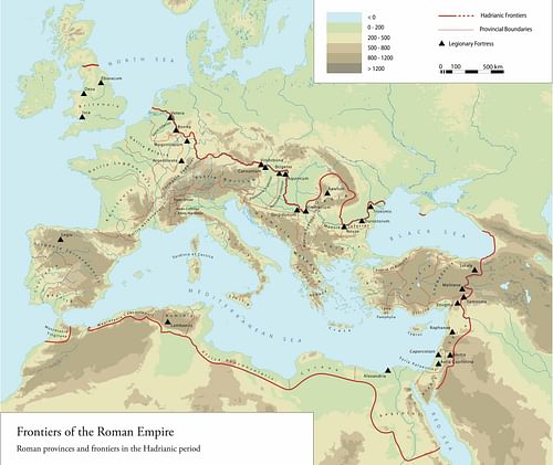
In the 2nd century CE, the [Roman Empire](https://www.worldhistory.org/Roman_Empire/) stretched from [Scotland](https://www.worldhistory.org/disambiguation/Scotland/) in northern [Europe](https://www.worldhistory.org/europe/) to the deserts of southern [Egypt](https://www.worldhistory.org/egypt/), encompassing the entirety of the [Mediterranean](https://www.worldhistory.org/disambiguation/mediterranean/) basin. Beyond that lay its borders. Where there was no natural frontier such as rivers, mountains, deserts, or sea, the Romans constructed artificial barriers.
These frontiers extended over 7,500 kilometres (4,660 mi), stretching from the Atlantic Ocean, across Europe to the Black Sea, through the deserts of the Middle East to the Red Sea, and across North [Africa](https://www.worldhistory.org/disambiguation/africa/). Germany's frontier ran beyond the upper reaches of the Rhine and Danube.
[  The Porta Praetoria of Saalburg Roman Fort Carole Raddato (CC BY-NC-SA) ](https://www.worldhistory.org/image/14423/the-porta-praetoria-of-saalburg-roman-fort/ "The Porta Praetoria of Saalburg Roman Fort")Around 2,000 years ago, the Romans extended their control into German territory and developed a nearly unbroken line of fortifications over 500 kilometres long (310 mi) with some 900 watchtowers and 120 forts. These military installations are still visible in the German landscape today and are known as the Upper Germanic-Rhaetian Limes. The subject of intensive surveying and archaeological investigation since the late 1800s, the German frontier is part of the transnational World Heritage Site "Frontiers of the [Roman](https://www.worldhistory.org/disambiguation/Roman/) [Empire](https://www.worldhistory.org/empire/)" together with [Hadrian's Wall](https://www.worldhistory.org/Hadrians_Wall/) and the [Antonine Wall](https://www.worldhistory.org/Antonine_Wall/).
[  Frontiers of the Roman Empire FRE Project (CC BY-NC) ](https://www.worldhistory.org/image/14438/frontiers-of-the-roman-empire/ "Frontiers of the Roman Empire")### The Limes
When the Roman historian [Tacitus](https://www.worldhistory.org/tacitus/) (l. c. 56 - c. 118 CE) wrote his *Germania* in 98 CE, he coined the term *limes*, which originally meant a military road along which troops advanced into unfriendly territory. Over time, the word *limes* was used to describe a land boundary and a frontier zone within or outside Roman territory. Today, the word *limes* refers to the Roman defence system and associated military installations constructed along the empire's borders. In the 2nd century CE, the [Roman army](https://www.worldhistory.org/Roman_Army/) developed an unbroken line of fortifications along their northern borders. In [England](https://www.worldhistory.org/disambiguation/england/), this defence system took the form of a [wall](https://www.worldhistory.org/wall/) – [Hadrian](https://www.worldhistory.org/hadrian/)'s Wall. A broad frontier strip was created in Germany, marked by a timber palisade, forts and fortlets (small cohort forts), and towers. Traces of these *limes* structures are still visible today in the German landscape, in part thanks to the preservation and restoration of foundation walls and full-size reconstructions.
The Germanic Limes that bounded the provinces of Germania Superior (Upper Germany) and Raetia (Rhaetia) was constructed in phases over several decades between the end of the 1st century CE and the mid-3rd century CE and took different forms. In its final stage, the Limes in Germania Superior consisted of a timber palisade or an 8-metre (26 ft) wide ditch, both overlooked by watchtowers built in stone. In Raetia, the Limes included a stone wall some 3 metres (9.8 ft) high with towers behind or on the wall. The system also had fortlets situated close to the Limes line and forts for auxiliary troops connected by road to the border. Whether the principal design of this linear frontier was to act as a strict boundary and provide defence against attacks, control [trade](https://www.worldhistory.org/disambiguation/trade/), or monitor the movement of people remains disputed. However, the latest research shows that the Limes was a controlled borderline that could be crossed at specified points.
[ 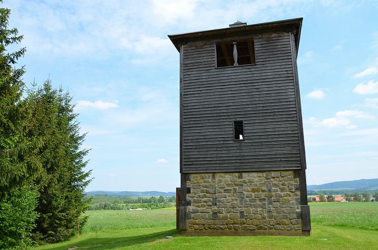 Reconstructed Limes Watchtower Wp 12/77 Carole Raddato (CC BY-NC-SA) ](https://www.worldhistory.org/image/14439/reconstructed-limes-watchtower-wp-1277/ "Reconstructed Limes Watchtower Wp 12/77")The Limes was maintained for over 150 years until the Roman army retreated behind the Rhine and Danube around 260 CE due to invasions by diverse Germanic tribes and the internal conflicts known as the [Crisis of the Third Century](https://www.worldhistory.org/Crisis_of_the_Third_Century/).
### Exploring the Upper-Germanic-Rhaetian Limes
In recent years, the Limes in Germany has been extensively developed as a tourist attraction. A German Limes Route (German: *Deutsche Limes-Straße*) allows the visitor to follow the course of the Limes along a signposted 700-kilometre (430 mi) tour, connecting the most important sights. These include partially or fully reconstructed watchtowers and forts as well as reconstructed portions of the Limes system such as ramparts, ditches, walls, and palisades. The German Limes Route also leads to various Roman and Limes museums. Additionally, circular paths (Limes Hiking Trail) in designated places allow visitors to explore portions of the ancient border in more detail on foot and enjoy nature and history together. Finally, a Limes Cycle Route enables the bicycle enthusiast to follow the course of the Limes through largely untouched landscapes, remote woodlands, and small villages.
Starting in Rheinbrohl (near Koblenz) on the Rhine, the German Limes Route meanders through forests, farmland, and more than 90 towns in four states (Rhineland-Palatinate, Hesse, Baden-Württemberg, and Bavaria) to Passau on the Danube. Together with the reconstructed portions of the Limes structures, large on-site information boards and newly built or redesigned Limes Museums allow visitors to experience [archaeology](https://www.worldhistory.org/Archaeology/) in a unique and exciting way.
The whole of the Upper Germanic-Rhaetian Limes is divided into 15 sections. Within each section, tower sites and fortlets are numbered consecutively. The abbreviation 'Wp' stands for *Wachtposten* (German for 'watchtower') and precedes the section and site number. Therefore, Wp 12/77 means watchtower No. 77 of the 12th Limes section.
[  Limes Information Boards Carole Raddato (CC BY-NC-SA) ](https://www.worldhistory.org/image/14454/limes-information-boards/ "Limes Information Boards")Driving, cycling, or hiking on the German Limes Route is an eventful journey through some beautiful and generally unspoilt German countryside. With signs and museums along the way, the visitor gains an excellent insight into the everyday life of troops stationed on the frontier. The Upper Germanic-Rhaetian Limes is a fascinating and impressive archaeological monument.
[  Signpost of the German Limes Road Mef.ellingen (CC BY-SA) ](https://www.worldhistory.org/image/14574/signpost-of-the-german-limes-road/ "Signpost of the German Limes Road")Notable highlights include the reconstructed Saalburg [Roman fort](https://www.worldhistory.org/Roman_Fort/) in Bad Homburg, a replica of a Roman fortlet in Pohl, the Roman museum in Osterburken, the Limes fort museum in Aalen, and the [Roman baths](https://www.worldhistory.org/Roman_Baths/) and Limes information centre in Weissenburg.
### Highlights of the Limes in Rhineland-Palatinate
The first 75 kilometres (46 miles) of the German Limes Road run through Rhineland-Palatinate. It begins on the right bank of the Rhine in Rheinbrohl to the fort at Holzhausen an der Haide in the beautiful forest of the Taunus mountain range. Along this route, 132 watchtowers, nine small forts, and nine cohort forts were located.
[ 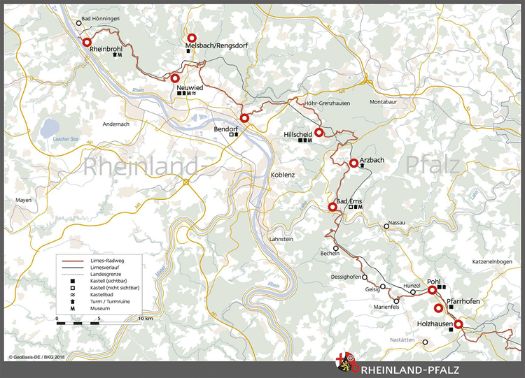 Map of the Limes in Rhineland-Palatinate, Germany Verein Deutsche Limes-Straße (German Limes Road Association) (Copyright) ](https://www.worldhistory.org/image/14514/map-of-the-limes-in-rhineland-palatinate-germany/ "Map of the Limes in Rhineland-Palatinate, Germany")At Rheinbrohl, the beginning of the Limes is marked by the reconstructed watchtower Wp 1/1 and information boards. The tower, built according to the state of research at the time of its construction in 1874, does not correspond to the current scientific findings and is therefore inaccurate. Rheinbrohl is also home to the [RömerWelt](http://www.roemer-welt.de/), the Limes Information Centre for the state of Rhineland-Palatinate, with an indoor interactive exhibition on everyday life on the Limes, and an outdoor area that includes reconstructed soldiers' rooms.
[  The Beginning of the Limes & Reconstructed Watchtower Wp 1/1 Carole Raddato (CC BY-NC-SA) ](https://www.worldhistory.org/image/14455/the-beginning-of-the-limes--reconstructed-watchtow/ "The Beginning of the Limes & Reconstructed Watchtower Wp 1/1")[  The RömerWelt Limes Information Centre Carole Raddato (CC BY-NC-SA) ](https://www.worldhistory.org/image/14485/the-romerwelt-limes-information-centre/ "The RömerWelt Limes Information Centre")An 8.4 kilometres (5 mi) long circular path starts at the car park of the RömerWelt. En route, the visitor reaches interesting places with reconstructions but also original finds from the Limes. A wooden tower replica was built as a lookout tower for Wp 1/9. Its viewing platform offers great views over the Rhine valley. Download the map of the RömerWeltWeg [here](https://www.roemer-welt.de/images/pdf-dokumente/2014/RoemerWeltWeg_Rheinbrohl.pdf).
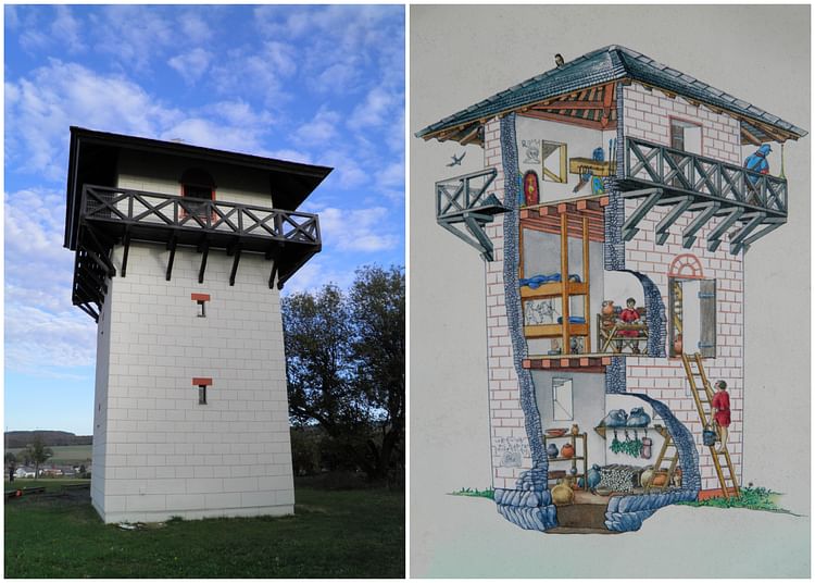
Another reconstructed watchtower can be seen near Hillscheid (Wp 1/68). It is one of a few authentic three-storey watchtowers, built in stone around 150 CE to replace the earlier timber ones. Its interior functions as a museum. Nearby are the foundation walls of the Fortlet Hillscheid and Wp 1/71.
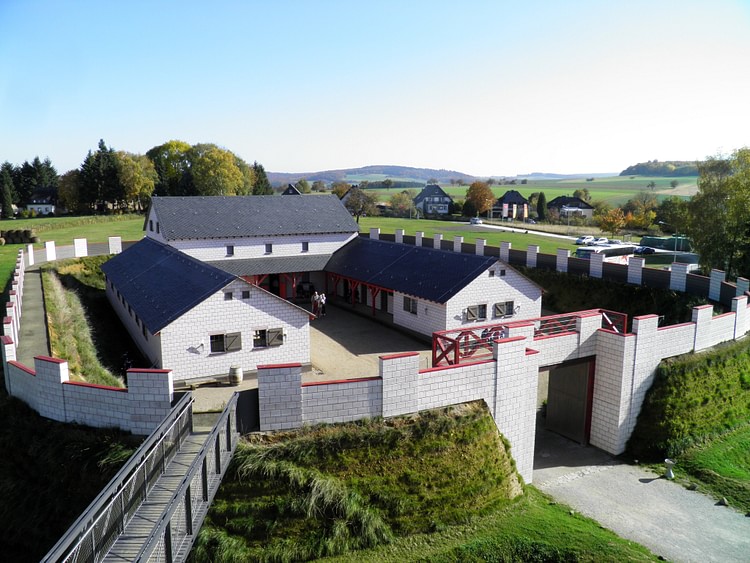
[  Reconstructed Limes Stone Watchtower (Wp 1/68) Carole Raddato (CC BY-NC-SA) ](https://www.worldhistory.org/image/14486/reconstructed-limes-stone-watchtower-wp-168/ "Reconstructed Limes Stone Watchtower (Wp 1/68)")On the outskirts of Pohl, an authentic replica of a small fort with a watchtower was designed as an [open-air museum](http://www.limeskastell-pohl.de/). Unique in Germany, this facility gives a vivid and plausible impression of life on the German frontier. The small fort in Pohl provided space for a *centuria* of 80 men. Built directly on the Limes demarcation line, fortlets were equipped with their own defensive system consisting of a circular V-shaped ditch and an earth wall made of stacked turf blocks. The interiors were occupied by U-shaped barrack blocks (*conturbernia*).
[  Reconstructed Roman Fortlet in Pohl, Germany Carole Raddato (CC BY-NC-SA) ](https://www.worldhistory.org/image/14491/reconstructed-roman-fortlet-in-pohl-germany/ "Reconstructed Roman Fortlet in Pohl, Germany")Farther east, in the woods of Holzhausen an der Haid, visitors on the German Limes Road will find one of the best-preserved Limes forts, the so-called Kastell Holzhausen. It was erected in the mid-3rd century CE during the reign of [Roman emperor](https://www.worldhistory.org/Roman_Emperor/) [Caracalla](https://www.worldhistory.org/Caracalla/) (r. 211-217 CE) and used until the abandonment of the Limes in 260 CE. The fort at Holzhausen was home to an infantry unit, the Cohors II Treverorum, consisting of 480 foot soldiers responsible for the various logistical tasks along the outer frontier. The foundation walls of the corner towers and the towers of the fort's four gates are exposed, as well as the stone foundations from the headquarters building (*principia*) with its semicircular apsis that contained the military standards (a*edes*).
[ 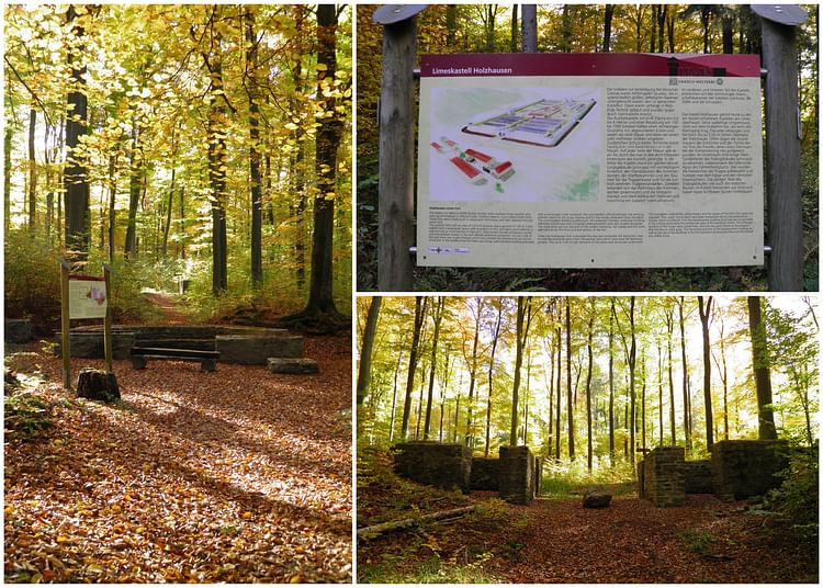 Holzhausen Roman Limes Fort, Germany Carole Raddato (CC BY-NC-SA) ](https://www.worldhistory.org/image/14492/holzhausen-roman-limes-fort-germany/ "Holzhausen Roman Limes Fort, Germany")### Highlights of the Limes in Hesse
In Hesse, the 150 kilometre (93 miles) section of the Limes runs from Bad Schwalbach, 20 kilometres (12 miles) northwest of Wiesbaden, then proceeds across the wooded heights of the Taunus mountain range before reaching the fertile landscape of the Wetterau just north of Frankfurt. The Limes then meet the Main River, which formed a natural boundary for about 50 kilometres (31 mi). About 49 forts and 200 watchtowers stood along the Hessian part of the Limes. Today, they exist in various states of preservation, but at the Saalburg, northwest of Bad Homburg, visitors will get the opportunity to visit [the only re-erected Roman fort](http://www.saalburgmuseum.de/en/) in the world and directly experience [Roman architecture](https://www.worldhistory.org/Roman_Architecture/).
[  Map of the Limes in Hesse, Germany Carole Raddato (Copyright) ](https://www.worldhistory.org/image/14515/map-of-the-limes-in-hesse-germany/ "Map of the Limes in Hesse, Germany")The Saalburg Roman Fort served as a base for frontier troops stationed along the German frontier for 150 years. It was built as a simple wood-and-earth fort towards the end of the 1st century CE, then converted into a larger stone fort around 135 CE. About 480 foot soldiers and 120 cavalrymen of the Second Raetian Cohort (Cohors II Raetorum) protected the Limes in the Upper Taunus. After the withdrawal of the Roman troops, the Saalburg fell into ruin. The first archaeological excavations at the Saalburg began in the middle of the 19th century. German Emperor Wilhelm II (r. 1888-1918) initiated the fort's reconstruction to serve as a research institute and open-air museum.
[  Saalburg Roman Fort, Germany Carole Raddato (CC BY-NC-SA) ](https://www.worldhistory.org/image/14506/saalburg-roman-fort-germany/ "Saalburg Roman Fort, Germany")The Saalburg fort offers the most extensive overview of the daily life of a [Roman legionary](https://www.worldhistory.org/Roman_Legionary/) and the civilian population who lived in the village (*vicus*) outside the fort. The museum, housed in several different buildings, is full of fascinating excavation finds, models, and replicas. In the TABERNA restaurant, visitors can choose from delicious Roman cuisine or local culinary specialities.
The reconstruction of another stone tower (Wp 3/26) can be found near the beautiful half-timbered town of Idstein. In the 2nd and 3rd centuries CE, the Romans soldiers used retractable ladders to get inside the tower as their entrance doors were all situated above ground level. Today, the three floors of the reconstructed tower are accessible via stairs. They are used as an exhibition space with original Roman finds from the state of Hesse and reconstructed pieces of equipment of Roman auxiliary soldiers.
[  Reconstructed Limes Watchtower Wp 3/26 Carole Raddato (CC BY-NC-SA) ](https://www.worldhistory.org/image/14493/reconstructed-limes-watchtower-wp-326/ "Reconstructed Limes Watchtower Wp 3/26")### Highlights of the Limes in Baden Württemberg
Numerous visible remains, museums, and reconstructions projects can be seen along the 164-kilometre-long (100 mi) section of the German Limes Route in Baden-Württemberg. It runs through different kinds of appealing landscapes, the Odenwald highlands, the Hohenlohe plateau and the Swabian-Franconian Forest, passing through towns such as Öhringen, Murrhardt, Welzheim, Lorch, and Aalen. 340 watchtowers, as well as 16 forts and 17 fortlets, have been located.
[ 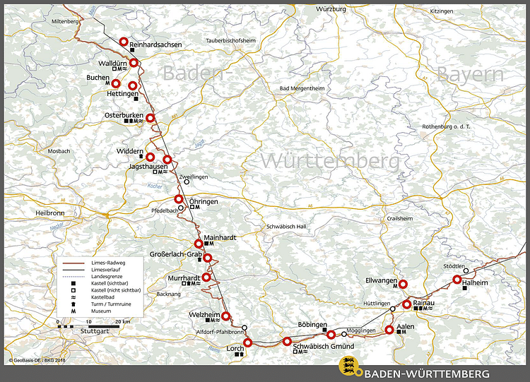 Map of the Limes in Baden Württemberg, Germany Carole Raddato (Copyright) ](https://www.worldhistory.org/image/14516/map-of-the-limes-in-baden-wurttemberg-germany/ "Map of the Limes in Baden Württemberg, Germany")Osterburken is the location of the best-preserved fort in Baden-Württemberg. It is also home to the [Römermuseum Osterburken](http://www.roemermuseum-osterburken.de/index.php?id=769), which presents finds from Osterburken and the region and provides information about the Romans on the Limes. The museum was constructed over a military bathhouse, the remains of which are exposed in the rear part of the museum. A reconstructed stone watchtower (Wp 8/32) with a wall, rampart, and ditch can also be seen about one kilometre (0.6 mi) south of the fort in the "Förstlein" area.
[ 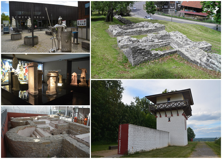 The Limes at Osterburken, Germany Carole Raddato (CC BY-NC-SA) ](https://www.worldhistory.org/image/14513/the-limes-at-osterburken-germany/ "The Limes at Osterburken, Germany")Other reconstructed watchtowers can be seen at Geisselhardt (Wp 9/64), at Grab (Wp 9/83), and near the Lorch Monastery (Wp 12/14).
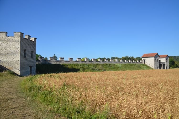
Further south at Welzheim, two forts originally stood in the 2nd and 3rd centuries CE. While the western fort (Westkastell) has disappeared, the smaller eastern one (Ostkastell) has in part survived. The eastern fort's west gate (*porta praetoria*) was reconstructed with ancient bricks and stones found in the fort's defensive ditch during excavations. An archaeological park was founded on the site with many replicas of [Roman sculpture](https://www.worldhistory.org/Roman_Sculpture/) and explanatory monuments plaques.
[  Welzheim Roman Limes Fort, Germany Carole Raddato (CC BY-NC-SA) ](https://www.worldhistory.org/image/14558/welzheim-roman-limes-fort-germany/ "Welzheim Roman Limes Fort, Germany")The German Limes Route then takes a sharp turn east to reach Aalen, where the Limes Information Centre for the state of Baden-Württemberg is located. Aalen was also the largest [Roman cavalry](https://www.worldhistory.org/Roman_Cavalry/) fort north of the Alps, covering 6 hectares (14 acres). The garrison, founded around 160 CE, was home to 1,000 soldiers of the Ala II Flavia Miliaria, the largest and most important troop on the whole Limes. The headquarters (*principia*) of the Aalen fort has been excavated and preserved, and the foundations of the *porta principalis sinistra*, the gate at the left‐hand end of the fort, can also be seen. A Roman cavalry barracks was partially reconstructed at a 1:1 scale in the adjacent archaeological park, while the museum provides comprehensive information about the Limes, the forts, [Roman armor and weapons](https://www.worldhistory.org/article/1692/roman-armor--weapons/), and the civilian settlements.
[  Aalen Roman Limes Fort, Germany Carole Raddato (CC BY-NC-SA) ](https://www.worldhistory.org/image/14560/aalen-roman-limes-fort-germany/ "Aalen Roman Limes Fort, Germany")Other highlights in Baden-Württemberg include the Limes-Park Rainau and the so-called Limes Gate Dalkingen, a unique monument built for the imperial visit of Emperor Caracalla to the province of Raetia in 213 CE.
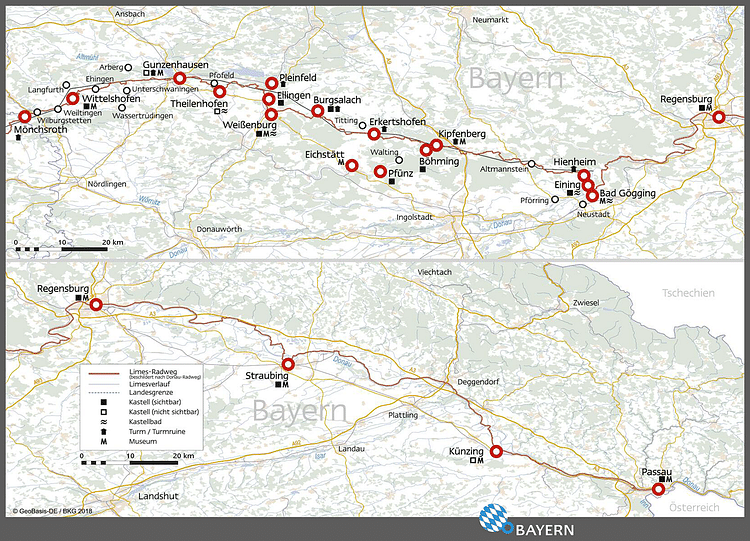
### Highlights of the Limes in Bavaria
The Limes reaches the Bavarian border at Mönchsroth, where the partly reconstructed Limes tower Wp 13/2 is located. It is also the start of the Rhaetian Limes, which then crosses Middle Franconia and Upper Bavaria territories, ending at the banks of the river Danube in Lower Bavaria. Around 180 watchtowers secured the 166 kilometres (103 mi) of the Rhaetian Limes in Bavaria and its hinterland. Subsequently, ten fortlets were built to guard key locations like road crossings, rivers, and steep valleys.
[  Map of the Limes in Bavaria, Germany Carole Raddato (Copyright) ](https://www.worldhistory.org/image/14517/map-of-the-limes-in-bavaria-germany/ "Map of the Limes in Bavaria, Germany")In Bavaria, the architectural and military elements of the Roman frontier have largely been preserved, and their foundations are still visible today. At the [Ruffenhofen Roman Park](http://www.roemerpark-ruffenhofen.de/index.php/en/), the outlines of Roman structures have been marked with vegetation, thus enabling visitors to visualise the individual elements. The Limes is marked by reconstructions and memorial stones at other locations, where no traces are discernible.
The remains of the Biriciana Roman fort is the main attraction of the picturesque town of Weißenburg, also home to the Bavarian Limes Information Centre. The site contains partly subterranean building remains, a reconstructed north gateway, large thermal baths, and a Roman Museum ([RömerMuseum](https://museen-weissenburg.de/de/unsere-museen/roemermuseum)), which houses [bronze](https://www.worldhistory.org/disambiguation/bronze/) statuettes from the Weißenburg treasure hoard.
[ 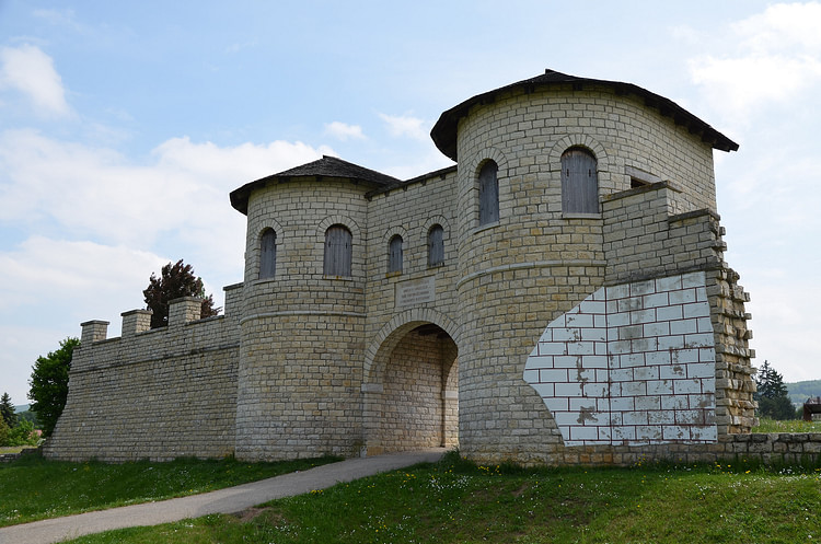 Reconstructed Gate of the Roman Fort Biriciana, Germany Carole Raddato (CC BY-SA) ](https://www.worldhistory.org/image/4710/reconstructed-gate-of-the-roman-fort-biriciana-ger/ "Reconstructed Gate of the Roman Fort Biriciana, Germany")The grounds of the Biriciana cavalry fort are entirely preserved and have been left open and designed as an archaeological park on the edge of the town centre. The Roman Baths are the best-preserved in Southern Germany. They were built by the military as civilian baths, and their remains are now housed within a shelter.
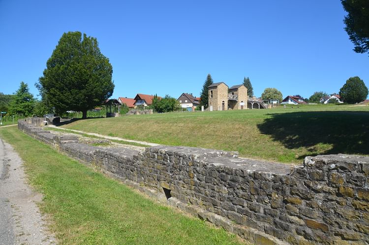
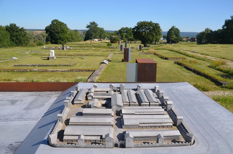
Another Limes highlight in Bavaria is Fort Vetoniana, a cohort camp near the village of Pfünz. It is one of the best-studied forts on the Limes. Likely constructed around 90 CE as a wooden and earth structure and later rebuilt in stone, Fort Vetoniana was garrisoned by a unit of 500 men, including some cavalry. Of historical importance are the remains of the double V-shaped ditches.
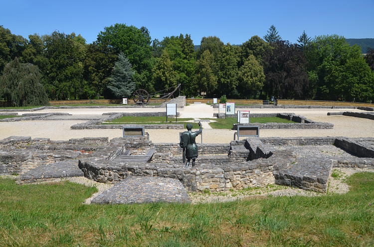
[  Vetoniana Roman Limes Fort, Germany Carole Raddato (CC BY-NC-SA) ](https://www.worldhistory.org/image/14566/vetoniana-roman-limes-fort-germany/ "Vetoniana Roman Limes Fort, Germany")The German Limes Road reaches the Danube at Eining around 30 kilometres (18 mi) southwest of Regensburg, where the [Roman military](https://www.worldhistory.org/Roman_Army/) camp of Abusina is located. Originally a timbered earth fort erected 79-81 CE, Abusina was replaced by a stone fort under [Antoninus Pius](https://www.worldhistory.org/Antoninus_Pius/) (r. 138-161 CE), and around 300 CE, a small, strongly fortified fortress was established. Excavations have revealed the headquarter building (*principia*), the commanding officer's house (*praetorium*), and a bath building with annexes. Two sanctuaries were also discovered north of the *vicus*.
[  Abusina Roman Limes Fort, Germany Carole Raddato (CC BY-NC-SA) ](https://www.worldhistory.org/image/14565/abusina-roman-limes-fort-germany/ "Abusina Roman Limes Fort, Germany")The Google map below has all the Limes locations mentioned in this article and many more. You will find additional photos, GPS coordinates, and links. You can download the German Limes Road 64-page brochure [here](https://www.limesstrasse.de/fileadmin/limesstrasse/images2019/service/prospekte/2016_DLS-Broschuere-ENGLISH.pdf) and find practical information on the German Limes Road official [website](http://www.limesstrasse.de/deutsche-limes-strasse/home/?L=1).
#### Editorial Review
This human-authored article has been reviewed by our editorial team before publication to ensure accuracy, reliability and adherence to academic standards in accordance with our [editorial policy](https://www.worldhistory.org/static/editorial-policy/).
## Bibliography
- [Breeze, David J. *The Frontiers of Imperial Rome.* Pen and Sword Military, 2019.](https://www.worldhistory.org/books/1526760800/)
- [Martin Kemkes. "Chapter 7/The Limes." *The Oxford Handbook of the Archaeology of Roman Germany* , edited by James, Simon & Krmnicek, Stefan. Oxford University Press, 2020.](https://www.worldhistory.org/books/0199665737/)
## About the Author
Carole maintains the popular ancient history photo-blog Following Hadrian, where she travels the ancient world in the footsteps of Emperor Hadrian.
- [Facebook Profile](https://www.facebook.com/FollowingHadrian)
- [X/Twitter Profile](https://twitter.com/carolemadge)
## Cite This Work
### APA
Raddato, C. (2021, September 09). A Visitor's Guide to Rome's Frontier in Germany. *World History Encyclopedia*.
### Chicago
Raddato, Carole. "A Visitor's Guide to Rome's Frontier in Germany." *World History Encyclopedia*, September 09, 2021. .
### MLA
Raddato, Carole. "A Visitor's Guide to Rome's Frontier in Germany." *World History Encyclopedia*, 09 Sep 2021, .
## License & Copyright
Submitted by [Carole Raddato](https://www.worldhistory.org/user/FollowingHadrian/ "User Page: Carole Raddato"), published on 09 September 2021. The copyright holder has published this content under the following license: [Creative Commons Attribution-NonCommercial-ShareAlike](https://creativecommons.org/licenses/by-nc-sa/4.0/deed.en). This license lets others remix, tweak, and build upon this content non-commercially, as long as they credit the author and license their new creations under the identical terms. When republishing on the web a hyperlink back to the original content source URL must be included. Please note that content linked from this page may have different licensing terms.